Property Record
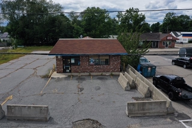
235 Main St, Oxford, MA 01540


Property Detail
235 Main St
Commercialnec
WORCESTER
VB
Massachusetts
B and X Area of moderate flood hazard, usually the area between the limits of the 100-year and 500-year floods.
0.33 AC
2025
Outlying Worcester
2025
Boston
753200
Worcester, MA
912 SF
OXFO-000033E-000000-P000001
NEARBY LISTINGS FOR SALE OR LEASE
-
-
View all Oxford listings for sale on LoopNet.com
DEMOGRAPHICS near 235 Main St
1 mile
3 mile
5 mile
2025 Total Population
4,884
13,639
42,187
2030 Population
4,975
13,965
43,190
Pop Growth 2025-2030
+ 1.86%
+ 2.39%
+ 2.38%
Average Age
44
43
43
2025 Total Households
1,985
5,340
17,217
HH Growth 2025-2030
+ 1.96%
+ 2.45%
+ 2.42%
Median Household Inc
$91,666
$110,555
$88,909
Avg Household Size
2.40
2.50
2.40
2025 Avg HH Vehicles
2.00
2.00
2.00
Median Home Value
$344,430
$374,294
$393,527
Median Year Built
1958
1971
1968
Nearby Places
Map Layers
Map Styles
 Street
 Aerial
Layers
 Traffic
 Biking
Places
Listings with unknown addresses are not visible on the map
- Restaurants
- Banks
- Shops
- Fitness
- Groceries
SALE & LEASE HISTORY
LISTING DATE
SALE/LEASE

Sep 17, 2019
For Sale
Nearby Properties
Address
Land Use
TOTAL SIZE
Lot Size
Zoning
Address
Land Use
TOTAL SIZE
Lot Size
Zoning
34 AC
LI
Address
Land Use
TOTAL SIZE
Lot Size
Zoning
15.60 AC
R2
Address
Land Use
TOTAL SIZE
Lot Size
Zoning
13.22 AC
INDUST
Address
Land Use
TOTAL SIZE
Lot Size
Zoning
175,000 SF
10.01 AC
LI
Address
Land Use
TOTAL SIZE
Lot Size
Zoning
199,444 SF
179.03 AC
R1
Address
Land Use
TOTAL SIZE
Lot Size
Zoning
105,657 SF
12.65 AC
HI
Address
Land Use
TOTAL SIZE
Lot Size
Zoning
20.31 AC
INDUST
Address
Land Use
TOTAL SIZE
Lot Size
Zoning
81,491 SF
6.64 AC
HI
Address
Land Use
TOTAL SIZE
Lot Size
Zoning
109,380 SF
27.60 AC
R2
Address
Land Use
TOTAL SIZE
Lot Size
Zoning
164,660 SF
15.40 AC
INDUST
Address
Land Use
TOTAL SIZE
Lot Size
Zoning
60 AC
INDUST
Address
Land Use
TOTAL SIZE
Lot Size
Zoning
50,065 SF
8.65 AC
R3
Address
Land Use
TOTAL SIZE
Lot Size
Zoning
45,054 SF
6.60 AC
HI
Address
Land Use
TOTAL SIZE
Lot Size
Zoning
3,600 SF
9.52 AC
GB
Address
Land Use
TOTAL SIZE
Lot Size
Zoning
51,609 SF
10.24 AC
R3
Address
Land Use
TOTAL SIZE
Lot Size
Zoning
8.96 AC
GB-5 W
Address
Land Use
TOTAL SIZE
Lot Size
Zoning
9,496 SF
13.25 AC
R3
Address
Land Use
TOTAL SIZE
Lot Size
Zoning
4.60 AC
I
Address
Land Use
TOTAL SIZE
Lot Size
Zoning
10 AC
LI
Address
Land Use
TOTAL SIZE
Lot Size
Zoning
70,471 SF
36.41 AC
I
Address
Land Use
TOTAL SIZE
Lot Size
Zoning
71,884 SF
7.01 AC
I
Address
Land Use
TOTAL SIZE
Lot Size
Zoning
69,192 SF
22.85 AC
I
Address
Land Use
TOTAL SIZE
Lot Size
Zoning
56,767 SF
5.12 AC
GB-4 W
Address
Land Use
TOTAL SIZE
Lot Size
Zoning
19,964 SF
7.50 AC
SFR-12
Address
Land Use
TOTAL SIZE
Lot Size
Zoning
32,192 SF
12.90 AC
R3
Address
Land Use
TOTAL SIZE
Lot Size
Zoning
21,045 SF
2 AC
INDUST
Address
Land Use
TOTAL SIZE
Lot Size
Zoning
14,478 SF
1.06 AC
R2
Address
Land Use
TOTAL SIZE
Lot Size
Zoning
2.81 AC
VB
Address
Land Use
TOTAL SIZE
Lot Size
Zoning
45,920 SF
3.50 AC
I
Address
Land Use
TOTAL SIZE
Lot Size
Zoning
8.47 AC
R1
The World's #1 Commercial Real Estate Marketplace
Connect with us
© 2026 CoStar Group
The information above has been obtained from sources believed reliable. While we do not doubt its accuracy we have not verified it and make no guarantee, warranty or representation about it. It is your responsibility to independently confirm its accuracy and completeness. Any projections, opinions, assumptions, or estimates used are for example only and do not represent the current or future performance of the property. The value of this transaction to you depends on tax and other factors which should be evaluated by your tax, financial, and legal advisors. You and your advisors should conduct a careful, independent investigation of the property to determine to your satisfaction the suitability of the property for your needs.