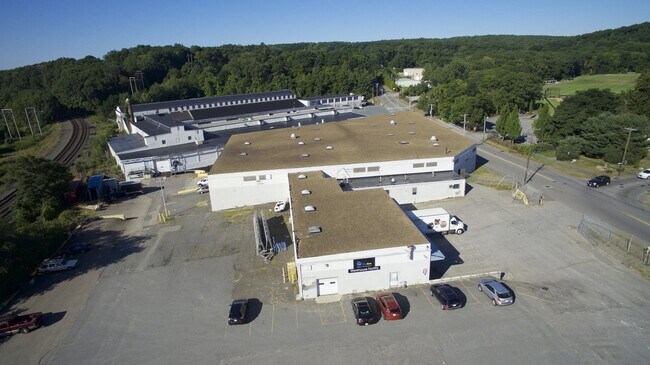
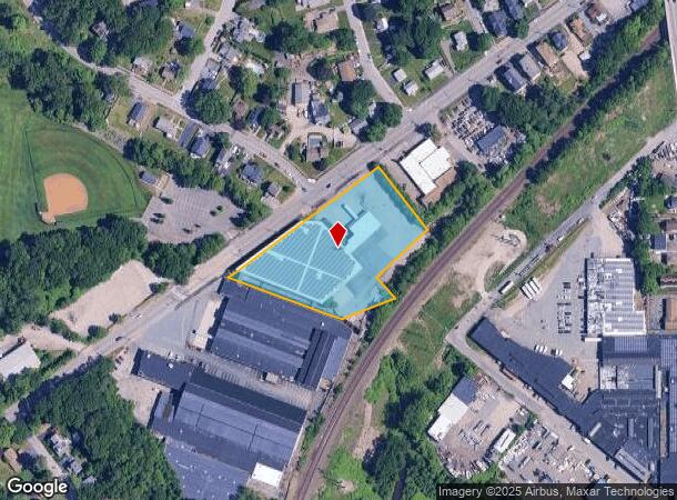
Property Record
233 Stafford St, Worcester, MA 01603
NEARBY LISTINGS FOR SALE OR LEASE
Property Detail
233 Stafford St
WORC-000028-000002-000002A
Worcester
Warehouse
Massachusetts
AE
2a
25027C0801E
2.32 AC
2025
Worcester Metro
2025
Boston
731002
Worcester, MA-CT
43,269 SF
DEMOGRAPHICS near 233 Stafford St
1 Mile
3 Mile
5 Mile
2024 Total Population
8,988
83,658
188,153
2029 Population
8,848
82,372
185,627
Pop Growth 2024-2029
(1.56%)
(1.54%)
(1.34%)
Average Age
41
38
38
2024 Total Households
3,460
30,769
71,849
HH Growth 2024-2029
(1.50%)
(1.58%)
(1.32%)
Median Household Inc
$83,015
$58,880
$61,994
Avg Household Size
2.50
2.50
2.40
2024 Avg HH Vehicles
2.00
1.00
1.00
Median Home Value
$276,890
$308,563
$320,437
Median Year Built
1950
1948
1950
Nearby Places
Map Layers
Map Styles
 Street
 Aerial
- Restaurants
- Banks
- Shops
- Fitness
- Groceries
PUBLIC TRANSPORTATION
COMMUTER RAIL
Worcester Union Station (Lake Shore Limited - Amtrak)
DRIVE
WALK
Distance
Worcester Union Station (Lake Shore Limited - Amtrak)
6 min
3.8 mi
Worcester (Framingham/Worcester Line - Massachusetts Bay Transportation Authority Commuter Rail (Purple Line))
DRIVE
WALK
Distance
Worcester (Framingham/Worcester Line - Massachusetts Bay Transportation Authority Commuter Rail (Purple Line))
7 min
4.0 mi
AIRPORT
Worcester Regional
DRIVE
WALK
Distance
Worcester Regional
10 min
4.0 mi
Freight Ports
Port of Boston
DRIVE
WALK
Distance
Port of Boston
67 min
49.0 mi
SALE & LEASE HISTORY
LISTING DATE
SALE/LEASE

Apr 07, 2022
For Lease
Nearby Properties
Address
Land Use
TOTAL SIZE
Lot Size
Zoning
Address
Land Use
TOTAL SIZE
Lot Size
Zoning
49.08 AC
SA
Address
Land Use
TOTAL SIZE
Lot Size
Zoning
49.51 AC
IN-S
Address
Land Use
TOTAL SIZE
Lot Size
Zoning
244,486 SF
42.64 AC
RL-7
Address
Land Use
TOTAL SIZE
Lot Size
Zoning
142.98 AC
Address
Land Use
TOTAL SIZE
Lot Size
Zoning
1,760 SF
105.54 AC
ML10
Address
Land Use
TOTAL SIZE
Lot Size
Zoning
164,378 SF
21.40 AC
Address
Land Use
TOTAL SIZE
Lot Size
Zoning
177.12 AC
RL-7
Address
Land Use
TOTAL SIZE
Lot Size
Zoning
3.55 AC
RG-5
Address
Land Use
TOTAL SIZE
Lot Size
Zoning
69.46 AC
RS-7
Address
Land Use
TOTAL SIZE
Lot Size
Zoning
159,355 SF
207.62 AC
RL-7
Address
Land Use
TOTAL SIZE
Lot Size
Zoning
3.43 AC
ML10
Address
Land Use
TOTAL SIZE
Lot Size
Zoning
41.84 AC
Address
Land Use
TOTAL SIZE
Lot Size
Zoning
643,250 SF
35.17 AC
RL-7
Address
Land Use
TOTAL SIZE
Lot Size
Zoning
175,200 SF
2.26 AC
BL-1
Address
Land Use
TOTAL SIZE
Lot Size
Zoning
36.67 AC
Address
Land Use
TOTAL SIZE
Lot Size
Zoning
2.78 AC
MG-2
Address
Land Use
TOTAL SIZE
Lot Size
Zoning
188,980 SF
20 AC
RL-7
Address
Land Use
TOTAL SIZE
Lot Size
Zoning
279,977 SF
17.80 AC
Address
Land Use
TOTAL SIZE
Lot Size
Zoning
200 SF
50.14 AC
MG-2
Address
Land Use
TOTAL SIZE
Lot Size
Zoning
14.66 AC
BG-2
Address
Land Use
TOTAL SIZE
Lot Size
Zoning
153,745 SF
10.99 AC
MG-2
Address
Land Use
TOTAL SIZE
Lot Size
Zoning
11 AC
RS-7
Address
Land Use
TOTAL SIZE
Lot Size
Zoning
92,604 SF
1 AC
Address
Land Use
TOTAL SIZE
Lot Size
Zoning
16.06 AC
RS-7
Address
Land Use
TOTAL SIZE
Lot Size
Zoning
210,001 SF
13.14 AC
Address
Land Use
TOTAL SIZE
Lot Size
Zoning
70,400 SF
17.10 AC
Address
Land Use
TOTAL SIZE
Lot Size
Zoning
11.28 AC
RL-7
Address
Land Use
TOTAL SIZE
Lot Size
Zoning
153,510 SF
1.67 AC
RG-5
Address
Land Use
TOTAL SIZE
Lot Size
Zoning
12.23 AC
RS-7
Address
Land Use
TOTAL SIZE
Lot Size
Zoning
176,000 SF
19.52 AC
RL-7
The World's #1 Commercial Real Estate Marketplace
Connect with us
© 2025 CoStar Group
The information above has been obtained from sources believed reliable. While we do not doubt its accuracy we have not verified it and make no guarantee, warranty or representation about it. It is your responsibility to independently confirm its accuracy and completeness. Any projections, opinions, assumptions, or estimates used are for example only and do not represent the current or future performance of the property. The value of this transaction to you depends on tax and other factors which should be evaluated by your tax, financial, and legal advisors. You and your advisors should conduct a careful, independent investigation of the property to determine to your satisfaction the suitability of the property for your needs.