Property Record
2330 37Th Ave Sw, Minot, ND 58701
NEARBY LISTINGS FOR SALE OR LEASE
-
-
View all Minot listings for lease on LoopNet.com
Property Detail
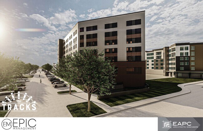
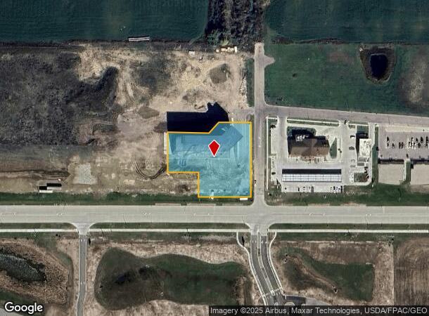
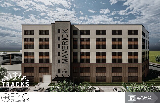
2330 37Th Ave Sw
Other Market Areas
Highlander Estates
Minot, ND
SUB: MI34F86 BLK: 1 LOT: 10 HIGHLANDER ESTATES FOURTH S/D LOT 10 BLOCK 1
MI34F860100100
Ward
Commercialacreage
North Dakota
2024
10
2024
1.57 AC
010602
Souris Valley
135,667 SF
DEMOGRAPHICS near 2330 37Th Ave Sw
1 Mile
3 Mile
5 Mile
2024 Total Population
3,663
25,506
48,661
2029 Population
3,605
25,120
47,931
Pop Growth 2024-2029
(1.58%)
(1.51%)
(1.50%)
Average Age
43
40
38
2024 Total Households
1,807
11,278
20,810
HH Growth 2024-2029
(1.55%)
(1.50%)
(1.55%)
Median Household Inc
$58,115
$67,816
$69,016
Avg Household Size
1.90
2.20
2.20
2024 Avg HH Vehicles
2.00
2.00
2.00
Median Home Value
$243,358
$239,397
$236,000
Median Year Built
1998
1984
1982
Nearby Places
Map Layers
Map Styles
 Street
 Aerial
- Restaurants
- Banks
- Shops
- Fitness
- Groceries
PUBLIC TRANSPORTATION
COMMUTER RAIL
Minot Amtrak Station (Empire Builder - Amtrak)
DRIVE
WALK
Distance
Minot Amtrak Station (Empire Builder - Amtrak)
8 min
3.8 mi
AIRPORT
Minot International
DRIVE
WALK
Distance
Minot International
13 min
6.5 mi
Freight Ports
Port Milwaukee
DRIVE
WALK
Distance
Port Milwaukee
942 min
870.4 mi
SALE & LEASE HISTORY
LISTING DATE
SALE/LEASE

Jan 04, 2023
For Lease
Nearby Properties
Address
Land Use
TOTAL SIZE
Lot Size
Zoning
Address
Land Use
TOTAL SIZE
Lot Size
Zoning
142,655 SF
9.54 AC
Address
Land Use
TOTAL SIZE
Lot Size
Zoning
55,908 SF
5.89 AC
Address
Land Use
TOTAL SIZE
Lot Size
Zoning
29,172 SF
9.19 AC
Address
Land Use
TOTAL SIZE
Lot Size
Zoning
41,710 SF
2.45 AC
Address
Land Use
TOTAL SIZE
Lot Size
Zoning
14,400 SF
4.46 AC
Address
Land Use
TOTAL SIZE
Lot Size
Zoning
39,667 SF
0.02 AC
Address
Land Use
TOTAL SIZE
Lot Size
Zoning
13.96 AC
Address
Land Use
TOTAL SIZE
Lot Size
Zoning
45,052 SF
3.78 AC
Address
Land Use
TOTAL SIZE
Lot Size
Zoning
24,471 SF
1.54 AC
Address
Land Use
TOTAL SIZE
Lot Size
Zoning
9.49 AC
Address
Land Use
TOTAL SIZE
Lot Size
Zoning
55,520 SF
2.50 AC
Address
Land Use
TOTAL SIZE
Lot Size
Zoning
8,060 SF
1.02 AC
Address
Land Use
TOTAL SIZE
Lot Size
Zoning
6,868 SF
1.52 AC
Address
Land Use
TOTAL SIZE
Lot Size
Zoning
7,222 SF
3.07 AC
Address
Land Use
TOTAL SIZE
Lot Size
Zoning
14,112 SF
1.71 AC
Address
Land Use
TOTAL SIZE
Lot Size
Zoning
36,633 SF
2.07 AC
Address
Land Use
TOTAL SIZE
Lot Size
Zoning
38,721 SF
1.60 AC
Address
Land Use
TOTAL SIZE
Lot Size
Zoning
36,158 SF
Address
Land Use
TOTAL SIZE
Lot Size
Zoning
7,200 SF
1.10 AC
Address
Land Use
TOTAL SIZE
Lot Size
Zoning
9,715 SF
0.86 AC
Address
Land Use
TOTAL SIZE
Lot Size
Zoning
2.63 AC
Address
Land Use
TOTAL SIZE
Lot Size
Zoning
19,520 SF
1.03 AC
Address
Land Use
TOTAL SIZE
Lot Size
Zoning
9,844 SF
1.27 AC
Address
Land Use
TOTAL SIZE
Lot Size
Zoning
10,770 SF
1.09 AC
Address
Land Use
TOTAL SIZE
Lot Size
Zoning
5,308 SF
1.01 AC
Address
Land Use
TOTAL SIZE
Lot Size
Zoning
5,400 SF
0.46 AC
Address
Land Use
TOTAL SIZE
Lot Size
Zoning
15.84 AC
Address
Land Use
TOTAL SIZE
Lot Size
Zoning
6,532 SF
0.05 AC
Address
Land Use
TOTAL SIZE
Lot Size
Zoning
3,894 SF
0.62 AC
The World's #1 Commercial Real Estate Marketplace
Connect with us
© 2025 CoStar Group
The information above has been obtained from sources believed reliable. While we do not doubt its accuracy we have not verified it and make no guarantee, warranty or representation about it. It is your responsibility to independently confirm its accuracy and completeness. Any projections, opinions, assumptions, or estimates used are for example only and do not represent the current or future performance of the property. The value of this transaction to you depends on tax and other factors which should be evaluated by your tax, financial, and legal advisors. You and your advisors should conduct a careful, independent investigation of the property to determine to your satisfaction the suitability of the property for your needs.