Property Record
2331 N Highway 29 N, Newnan, GA 30265
NEARBY LISTINGS FOR SALE OR LEASE
-
-
View all Newnan listings for sale on LoopNet.com
Property Detail
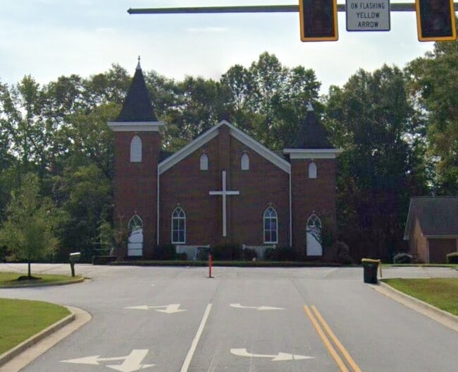
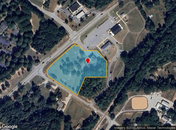
2331 N Highway 29 N
084-5140-003A
CHURCH/4.96 AC LL 140 LD 5 (JONES CHAPEL CHU
Religious
Coweta
X
Georgia
13077C0142D
140
0
4.96 AC
2025
Fayette/Coweta County
170304
Atlanta
7,743 SF
Atlanta-Sandy Springs-Roswell, GA
DEMOGRAPHICS near 2331 N Highway 29 N
1 Mile
3 Mile
5 Mile
2024 Total Population
839
14,930
66,580
2029 Population
891
16,221
73,470
Pop Growth 2024-2029
+ 6.20%
+ 8.65%
+ 10.35%
Average Age
45
41
40
2024 Total Households
338
5,932
25,433
HH Growth 2024-2029
+ 5.62%
+ 8.63%
+ 10.41%
Median Household Inc
$76,346
$90,055
$85,907
Avg Household Size
2.30
2.50
2.60
2024 Avg HH Vehicles
2.00
2.00
2.00
Median Home Value
$277,011
$329,926
$281,839
Median Year Built
1993
1997
1999
Nearby Places
- Restaurants
- Banks
- Shops
- Fitness
- Groceries
PUBLIC TRANSPORTATION
AIRPORT
Hartsfield - Jackson Atlanta International
DRIVE
WALK
Distance
Hartsfield - Jackson Atlanta International
38 min
28.5 mi
Freight Ports
Georgia Ports - Savannah
DRIVE
WALK
Distance
Georgia Ports - Savannah
300 min
255.0 mi
Nearby Properties
Address
Land Use
TOTAL SIZE
Lot Size
Zoning
Address
Land Use
TOTAL SIZE
Lot Size
Zoning
1,001,000 SF
118.56 AC
R1
Address
Land Use
TOTAL SIZE
Lot Size
Zoning
1,955,650 SF
101.74 AC
M
Address
Land Use
TOTAL SIZE
Lot Size
Zoning
1,079,000 SF
73.44 AC
M
Address
Land Use
TOTAL SIZE
Lot Size
Zoning
1,206,927 SF
109.06 AC
R1
Address
Land Use
TOTAL SIZE
Lot Size
Zoning
1,206,927 SF
109.06 AC
R1
Address
Land Use
TOTAL SIZE
Lot Size
Zoning
403,472 SF
61.64 AC
M
Address
Land Use
TOTAL SIZE
Lot Size
Zoning
349,504 SF
26.40 AC
C2
Address
Land Use
TOTAL SIZE
Lot Size
Zoning
196,093 SF
17.31 AC
002
Address
Land Use
TOTAL SIZE
Lot Size
Zoning
446,159 SF
49.05 AC
M
Address
Land Use
TOTAL SIZE
Lot Size
Zoning
229,770 SF
30 AC
001
Address
Land Use
TOTAL SIZE
Lot Size
Zoning
770,898 SF
215.23 AC
M
Address
Land Use
TOTAL SIZE
Lot Size
Zoning
76,445 SF
25.12 AC
R1
Address
Land Use
TOTAL SIZE
Lot Size
Zoning
367,120 SF
28.64 AC
M
Address
Land Use
TOTAL SIZE
Lot Size
Zoning
457,922 SF
45.16 AC
R1
Address
Land Use
TOTAL SIZE
Lot Size
Zoning
230,359 SF
51.61 AC
R1
Address
Land Use
TOTAL SIZE
Lot Size
Zoning
102,007 SF
18.92 AC
002
Address
Land Use
TOTAL SIZE
Lot Size
Zoning
215,344 SF
28.12 AC
R1
Address
Land Use
TOTAL SIZE
Lot Size
Zoning
299,520 SF
32.45 AC
R1
Address
Land Use
TOTAL SIZE
Lot Size
Zoning
80,744 SF
72.97 AC
R1
Address
Land Use
TOTAL SIZE
Lot Size
Zoning
162,627 SF
18.96 AC
M
Address
Land Use
TOTAL SIZE
Lot Size
Zoning
134,417 SF
13.01 AC
R1
Address
Land Use
TOTAL SIZE
Lot Size
Zoning
108,138 SF
6.36 AC
002
Address
Land Use
TOTAL SIZE
Lot Size
Zoning
115,754 SF
13.80 AC
C2
Address
Land Use
TOTAL SIZE
Lot Size
Zoning
105,900 SF
12.35 AC
M
Address
Land Use
TOTAL SIZE
Lot Size
Zoning
153,943 SF
16.20 AC
ND
Address
Land Use
TOTAL SIZE
Lot Size
Zoning
131,541 SF
19.23 AC
ND
Address
Land Use
TOTAL SIZE
Lot Size
Zoning
203,141 SF
20.30 AC
ND
Address
Land Use
TOTAL SIZE
Lot Size
Zoning
186,249 SF
17.99 AC
R1
Address
Land Use
TOTAL SIZE
Lot Size
Zoning
68,255 SF
14.79 AC
C2
Address
Land Use
TOTAL SIZE
Lot Size
Zoning
140,458 SF
7.78 AC
M
The World's #1 Commercial Real Estate Marketplace
Connect with us
© 2025 CoStar Group
The information above has been obtained from sources believed reliable. While we do not doubt its accuracy we have not verified it and make no guarantee, warranty or representation about it. It is your responsibility to independently confirm its accuracy and completeness. Any projections, opinions, assumptions, or estimates used are for example only and do not represent the current or future performance of the property. The value of this transaction to you depends on tax and other factors which should be evaluated by your tax, financial, and legal advisors. You and your advisors should conduct a careful, independent investigation of the property to determine to your satisfaction the suitability of the property for your needs.