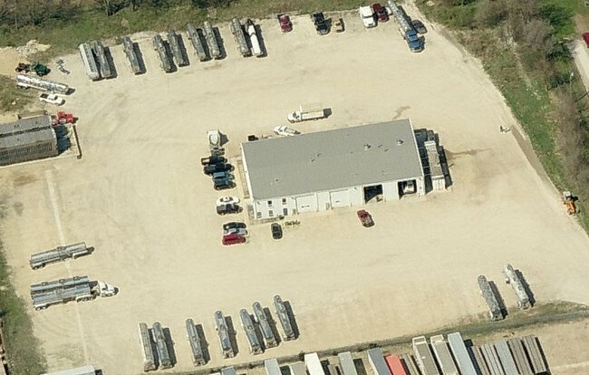
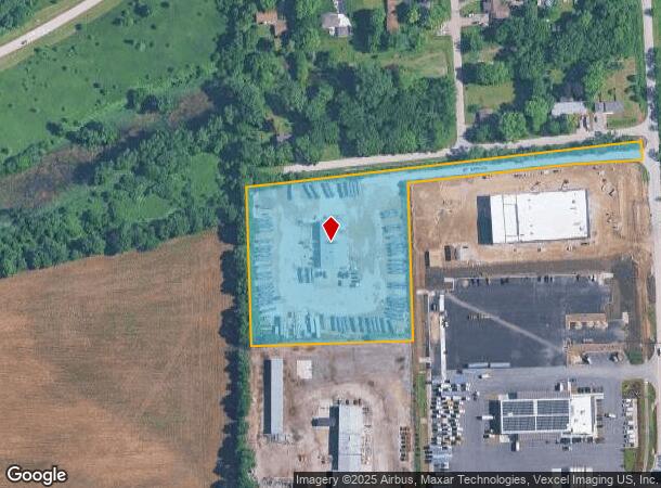
Property Record
23330 S Frontage Rd W, Channahon, IL 60410

NEARBY LISTINGS FOR SALE OR LEASE
Property Detail
23330 S Frontage Rd W
04-10-04-208-019
THAT PRT OF THE E1/2 OF THE NE1/4 OF SEC. 4, T34N-R9E, DAF: COMM AT THE SW COR OF THE SD E1/2 OF THE NE1/4; THC N 01 DEG 13'1
Industrialgeneral
Will
X
Illinois
17197C0255G
5 AC
2024
Joliet Area
2024
Chicago
883305
Chicago-Naperville-Elgin, IL-IN-WI
15,850 SF
DEMOGRAPHICS near 23330 S Frontage Rd W
1 Mile
3 Mile
5 Mile
2024 Total Population
710
12,527
49,358
2029 Population
710
12,557
49,791
Pop Growth 2024-2029
0.00%
+ 0.24%
+ 0.88%
Average Age
44
41
39
2024 Total Households
276
4,418
17,281
HH Growth 2024-2029
(0.36%)
+ 0.20%
+ 0.76%
Median Household Inc
$82,986
$105,507
$101,172
Avg Household Size
2.60
2.80
2.80
2024 Avg HH Vehicles
2.00
2.00
2.00
Median Home Value
$228,309
$270,838
$268,018
Median Year Built
1972
1990
1998
Nearby Places
Map Layers
Map Styles
 Street
 Aerial
- Restaurants
- Banks
- Shops
- Fitness
- Groceries
PUBLIC TRANSPORTATION
COMMUTER RAIL
Joliet Station (Heritage Corridor Line - Northeast Illinois Regional Commuter Railroad (Metra), Rock Island District Line - Northeast Illinois Regional Commuter Railroad (Metra))
DRIVE
WALK
Distance
Joliet Station (Heritage Corridor Line - Northeast Illinois Regional Commuter Railroad (Metra), Rock Island District Line - Northeast Illinois Regional Commuter Railroad (Metra))
18 min
9.3 mi
AIRPORT
Chicago Midway International
DRIVE
WALK
Distance
Chicago Midway International
52 min
38.7 mi
Nearby Properties
Address
Land Use
TOTAL SIZE
Lot Size
Zoning
Address
Land Use
TOTAL SIZE
Lot Size
Zoning
79.79 AC
Address
Land Use
TOTAL SIZE
Lot Size
Zoning
75.30 AC
Address
Land Use
TOTAL SIZE
Lot Size
Zoning
273.07 AC
Address
Land Use
TOTAL SIZE
Lot Size
Zoning
50.58 AC
Address
Land Use
TOTAL SIZE
Lot Size
Zoning
146.25 AC
Address
Land Use
TOTAL SIZE
Lot Size
Zoning
57.52 AC
Address
Land Use
TOTAL SIZE
Lot Size
Zoning
48.10 AC
Address
Land Use
TOTAL SIZE
Lot Size
Zoning
51.97 AC
Address
Land Use
TOTAL SIZE
Lot Size
Zoning
502,836 SF
24.99 AC
Address
Land Use
TOTAL SIZE
Lot Size
Zoning
35.65 AC
Address
Land Use
TOTAL SIZE
Lot Size
Zoning
459,070 SF
22.35 AC
Address
Land Use
TOTAL SIZE
Lot Size
Zoning
20.37 AC
Address
Land Use
TOTAL SIZE
Lot Size
Zoning
175.60 AC
Address
Land Use
TOTAL SIZE
Lot Size
Zoning
322,874 SF
13.71 AC
Address
Land Use
TOTAL SIZE
Lot Size
Zoning
22.74 AC
Address
Land Use
TOTAL SIZE
Lot Size
Zoning
15.31 AC
Address
Land Use
TOTAL SIZE
Lot Size
Zoning
309,840 SF
13.24 AC
Address
Land Use
TOTAL SIZE
Lot Size
Zoning
277,776 SF
14.17 AC
Address
Land Use
TOTAL SIZE
Lot Size
Zoning
17.58 AC
Address
Land Use
TOTAL SIZE
Lot Size
Zoning
250,560 SF
11.18 AC
Address
Land Use
TOTAL SIZE
Lot Size
Zoning
259,200 SF
17.87 AC
Address
Land Use
TOTAL SIZE
Lot Size
Zoning
240,468 SF
10.31 AC
Address
Land Use
TOTAL SIZE
Lot Size
Zoning
23.22 AC
Address
Land Use
TOTAL SIZE
Lot Size
Zoning
Address
Land Use
TOTAL SIZE
Lot Size
Zoning
205,200 SF
5.66 AC
Address
Land Use
TOTAL SIZE
Lot Size
Zoning
5.39 AC
Address
Land Use
TOTAL SIZE
Lot Size
Zoning
48,172 SF
21.06 AC
Address
Land Use
TOTAL SIZE
Lot Size
Zoning
16.48 AC
Address
Land Use
TOTAL SIZE
Lot Size
Zoning
22.50 AC
Address
Land Use
TOTAL SIZE
Lot Size
Zoning
140,000 SF
7.16 AC
The World's #1 Commercial Real Estate Marketplace
Connect with us
© 2025 CoStar Group
The information above has been obtained from sources believed reliable. While we do not doubt its accuracy we have not verified it and make no guarantee, warranty or representation about it. It is your responsibility to independently confirm its accuracy and completeness. Any projections, opinions, assumptions, or estimates used are for example only and do not represent the current or future performance of the property. The value of this transaction to you depends on tax and other factors which should be evaluated by your tax, financial, and legal advisors. You and your advisors should conduct a careful, independent investigation of the property to determine to your satisfaction the suitability of the property for your needs.