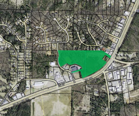
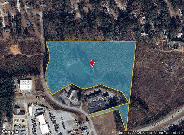
Property Record
2334 E Highway 166 St, Carrollton, GA 30116

NEARBY LISTINGS FOR SALE OR LEASE
Property Detail
2334 E Highway 166 St
Atlanta-Sandy Springs-Roswell, GA
Chuck Puckett
131-0110
V/TR-2 (11.78AC) E/HWY 166
Commercialnec
Carroll
X
Georgia
13045C0260D
11.78 AC
2025
Villa Rica/West Outlying
2025
Atlanta
910704
DEMOGRAPHICS near 2334 E Highway 166 St
1 Mile
3 Mile
5 Mile
2024 Total Population
2,272
12,741
35,429
2029 Population
2,521
14,121
39,337
Pop Growth 2024-2029
+ 10.96%
+ 10.83%
+ 11.03%
Average Age
36
37
38
2024 Total Households
788
4,539
12,943
HH Growth 2024-2029
+ 11.04%
+ 10.86%
+ 11.11%
Median Household Inc
$54,960
$54,225
$56,043
Avg Household Size
2.80
2.80
2.60
2024 Avg HH Vehicles
2.00
2.00
2.00
Median Home Value
$156,540
$175,214
$215,165
Median Year Built
1987
1988
1988
Nearby Places
Map Layers
Map Styles
 Street
 Aerial
- Restaurants
- Banks
- Shops
- Fitness
- Groceries
SALE & LEASE HISTORY
LISTING DATE
SALE/LEASE

Jun 26, 2019
For Sale
Jan 18, 2024
For Sale
Nearby Properties
Address
Land Use
TOTAL SIZE
Lot Size
Zoning
Address
Land Use
TOTAL SIZE
Lot Size
Zoning
56,288 SF
4.69 AC
C2
Address
Land Use
TOTAL SIZE
Lot Size
Zoning
163,568 SF
16.80 AC
C2
Address
Land Use
TOTAL SIZE
Lot Size
Zoning
45,480 SF
62.18 AC
R20
Address
Land Use
TOTAL SIZE
Lot Size
Zoning
29,561 SF
5.89 AC
C2
Address
Land Use
TOTAL SIZE
Lot Size
Zoning
100.74 AC
PUD
Address
Land Use
TOTAL SIZE
Lot Size
Zoning
63,888 SF
8.40 AC
I
Address
Land Use
TOTAL SIZE
Lot Size
Zoning
96.23 AC
M1
Address
Land Use
TOTAL SIZE
Lot Size
Zoning
46,146 SF
5.74 AC
C
Address
Land Use
TOTAL SIZE
Lot Size
Zoning
27,572 SF
1.71 AC
C2
Address
Land Use
TOTAL SIZE
Lot Size
Zoning
22,580 SF
9.71 AC
R2
Address
Land Use
TOTAL SIZE
Lot Size
Zoning
32,390 SF
9.84 AC
R2
Address
Land Use
TOTAL SIZE
Lot Size
Zoning
9,920 SF
1.17 AC
C2
Address
Land Use
TOTAL SIZE
Lot Size
Zoning
38,400 SF
4.77 AC
I
Address
Land Use
TOTAL SIZE
Lot Size
Zoning
38,182 SF
28.01 AC
C
Address
Land Use
TOTAL SIZE
Lot Size
Zoning
5,121 SF
2.56 AC
C2
Address
Land Use
TOTAL SIZE
Lot Size
Zoning
33,076 SF
11.86 AC
COMM/AG
Address
Land Use
TOTAL SIZE
Lot Size
Zoning
67,902 SF
12.45 AC
C2
Address
Land Use
TOTAL SIZE
Lot Size
Zoning
17,500 SF
25.60 AC
C2
Address
Land Use
TOTAL SIZE
Lot Size
Zoning
5,577 SF
1.31 AC
C2
Address
Land Use
TOTAL SIZE
Lot Size
Zoning
12,700 SF
1.58 AC
RESIDENTIA
Address
Land Use
TOTAL SIZE
Lot Size
Zoning
46,132 SF
6.42 AC
C2
Address
Land Use
TOTAL SIZE
Lot Size
Zoning
5,436 SF
1.50 AC
C2
Address
Land Use
TOTAL SIZE
Lot Size
Zoning
Address
Land Use
TOTAL SIZE
Lot Size
Zoning
47,686 SF
14.26 AC
R2
Address
Land Use
TOTAL SIZE
Lot Size
Zoning
37,550 SF
7.56 AC
C2
Address
Land Use
TOTAL SIZE
Lot Size
Zoning
4,440 SF
2.14 AC
C2
Address
Land Use
TOTAL SIZE
Lot Size
Zoning
21,700 SF
2.15 AC
I
Address
Land Use
TOTAL SIZE
Lot Size
Zoning
20,700 SF
5 AC
C2
Address
Land Use
TOTAL SIZE
Lot Size
Zoning
36,200 SF
2.50 AC
C
Address
Land Use
TOTAL SIZE
Lot Size
Zoning
17,000 SF
4.40 AC
C2
The World's #1 Commercial Real Estate Marketplace
Connect with us
© 2025 CoStar Group
The information above has been obtained from sources believed reliable. While we do not doubt its accuracy we have not verified it and make no guarantee, warranty or representation about it. It is your responsibility to independently confirm its accuracy and completeness. Any projections, opinions, assumptions, or estimates used are for example only and do not represent the current or future performance of the property. The value of this transaction to you depends on tax and other factors which should be evaluated by your tax, financial, and legal advisors. You and your advisors should conduct a careful, independent investigation of the property to determine to your satisfaction the suitability of the property for your needs.