Property Record
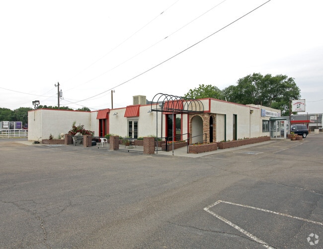
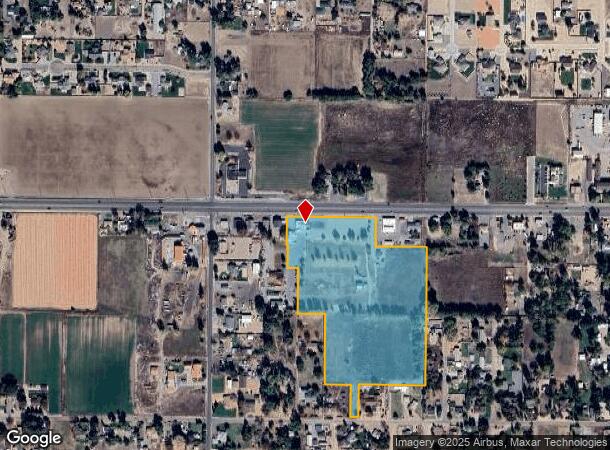
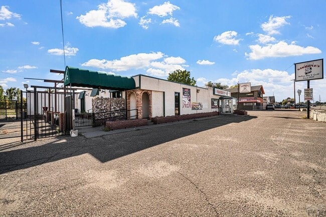
23344 E Us Highway 50, Pueblo, CO 81006
This Property Is For Sale
NEARBY LISTINGS FOR SALE OR LEASE
Property Detail
23344 E Us Highway 50
Pueblo, CO
Com-St Charles Mesa
1-4-03-0-16-104
PARCEL A LOT LINE REARRANGEMENT NO. 2021-002 FORMERLY,#14-030-16-100 + 14-030-46-001
Commercialacreage
Pueblo
2024
Colorado
2024
16.42 AC
003104
Colorado East Area
8,411 SF
Other Market Areas
DEMOGRAPHICS near 23344 E Us Highway 50
1 Mile
3 Mile
5 Mile
2024 Total Population
2,497
19,200
71,052
2029 Population
2,527
19,681
72,847
Pop Growth 2024-2029
+ 1.20%
+ 2.51%
+ 2.53%
Average Age
44
40
40
2024 Total Households
986
7,281
28,919
HH Growth 2024-2029
+ 1.12%
+ 2.51%
+ 2.66%
Median Household Inc
$70,462
$43,273
$41,030
Avg Household Size
2.50
2.60
2.30
2024 Avg HH Vehicles
3.00
2.00
2.00
Median Home Value
$291,891
$243,468
$203,679
Median Year Built
1970
1968
1957
Nearby Places
- Restaurants
- Banks
- Shops
- Fitness
- Groceries
Nearby Properties
Address
Land Use
TOTAL SIZE
Lot Size
Zoning
Address
Land Use
TOTAL SIZE
Lot Size
Zoning
65,508 SF
3.18 AC
Address
Land Use
TOTAL SIZE
Lot Size
Zoning
71,345 SF
5.17 AC
Address
Land Use
TOTAL SIZE
Lot Size
Zoning
71,936 SF
3.43 AC
R4:RES/MUL
Address
Land Use
TOTAL SIZE
Lot Size
Zoning
27,682 SF
1.85 AC
S-1
Address
Land Use
TOTAL SIZE
Lot Size
Zoning
25,714 SF
17.61 AC
Address
Land Use
TOTAL SIZE
Lot Size
Zoning
225,504 SF
37.40 AC
I2:IND/MAN
Address
Land Use
TOTAL SIZE
Lot Size
Zoning
16,800 SF
6.02 AC
Address
Land Use
TOTAL SIZE
Lot Size
Zoning
26,550 SF
3.52 AC
S1:SPC/PUB
Address
Land Use
TOTAL SIZE
Lot Size
Zoning
29,337 SF
6.02 AC
I2:IND/MAN
Address
Land Use
TOTAL SIZE
Lot Size
Zoning
14,596 SF
17.44 AC
Address
Land Use
TOTAL SIZE
Lot Size
Zoning
663.63 AC
Address
Land Use
TOTAL SIZE
Lot Size
Zoning
9,903 SF
1.33 AC
R-5
Address
Land Use
TOTAL SIZE
Lot Size
Zoning
155,800 SF
16.46 AC
I1:IND/PAR
Address
Land Use
TOTAL SIZE
Lot Size
Zoning
6,384 SF
0.81 AC
R-3
Address
Land Use
TOTAL SIZE
Lot Size
Zoning
50,720 SF
6.15 AC
I2:IND/MAN
Address
Land Use
TOTAL SIZE
Lot Size
Zoning
80,700 SF
9.89 AC
A2:AG/1&2
Address
Land Use
TOTAL SIZE
Lot Size
Zoning
50,720 SF
6.23 AC
I2:IND/MAN
Address
Land Use
TOTAL SIZE
Lot Size
Zoning
135,019 SF
19.10 AC
I2:IND/MAN
Address
Land Use
TOTAL SIZE
Lot Size
Zoning
123,180 SF
2.92 AC
R4:RES/MUL
Address
Land Use
TOTAL SIZE
Lot Size
Zoning
27,720 SF
1.38 AC
R4:RES/MUL
Address
Land Use
TOTAL SIZE
Lot Size
Zoning
6,666 SF
0.55 AC
R4:RES/MUL
Address
Land Use
TOTAL SIZE
Lot Size
Zoning
58,320 SF
7.66 AC
I1:IND/PAR
Address
Land Use
TOTAL SIZE
Lot Size
Zoning
12.79 AC
R-2
Address
Land Use
TOTAL SIZE
Lot Size
Zoning
26,377 SF
6.24 AC
I2:IND/MAN
Address
Land Use
TOTAL SIZE
Lot Size
Zoning
30,300 SF
2.13 AC
B4:COMM/RE
Address
Land Use
TOTAL SIZE
Lot Size
Zoning
30,030 SF
0.37 AC
I2:IND/MAN
Address
Land Use
TOTAL SIZE
Lot Size
Zoning
5,872 SF
1.43 AC
Address
Land Use
TOTAL SIZE
Lot Size
Zoning
33,610 SF
7.10 AC
Address
Land Use
TOTAL SIZE
Lot Size
Zoning
14,969 SF
16.73 AC
100
Address
Land Use
TOTAL SIZE
Lot Size
Zoning
3,754 SF
0.55 AC
B4:COMM/RE
The World's #1 Commercial Real Estate Marketplace
Connect with us
© 2025 CoStar Group
The information above has been obtained from sources believed reliable. While we do not doubt its accuracy we have not verified it and make no guarantee, warranty or representation about it. It is your responsibility to independently confirm its accuracy and completeness. Any projections, opinions, assumptions, or estimates used are for example only and do not represent the current or future performance of the property. The value of this transaction to you depends on tax and other factors which should be evaluated by your tax, financial, and legal advisors. You and your advisors should conduct a careful, independent investigation of the property to determine to your satisfaction the suitability of the property for your needs.