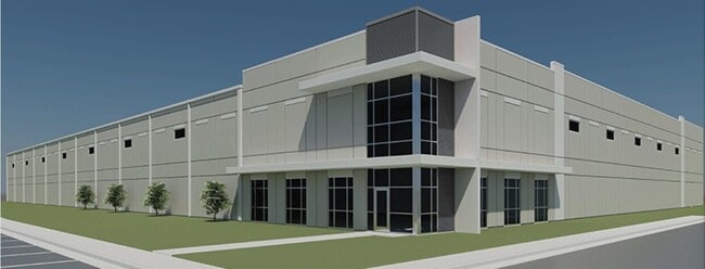
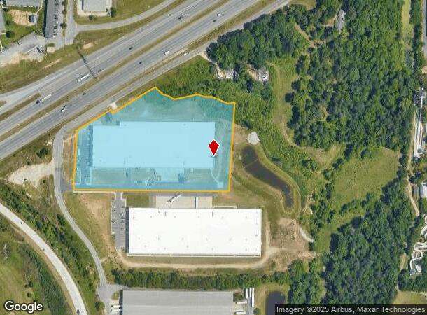
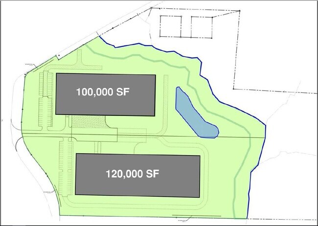
Property Record
2335 Campground Rd, Greensboro, NC 27406
NEARBY LISTINGS FOR SALE OR LEASE
Property Detail
2335 Campground Rd
0231776
BUSINESS PARK 85 LO:1B
Industrialgeneral
Guilford
X
North Carolina
3710785200J
1b
2024
6.41 AC
2025
Central Guilford County
016701
Greensboro/Winston-Salem
109,740 SF
Greensboro-High Point, NC
DEMOGRAPHICS near 2335 Campground Rd
1 Mile
3 Mile
5 Mile
2024 Total Population
2,733
45,240
124,825
2029 Population
2,720
44,982
124,374
Pop Growth 2024-2029
(0.48%)
(0.57%)
(0.36%)
Average Age
39
38
37
2024 Total Households
1,081
18,482
49,601
HH Growth 2024-2029
(0.46%)
(0.60%)
(0.32%)
Median Household Inc
$51,526
$49,167
$51,146
Avg Household Size
2.40
2.40
2.30
2024 Avg HH Vehicles
2.00
2.00
2.00
Median Home Value
$148,376
$146,460
$166,115
Median Year Built
1981
1983
1983
Nearby Places
Map Layers
Map Styles
 Street
 Aerial
- Restaurants
- Banks
- Shops
- Fitness
- Groceries
PUBLIC TRANSPORTATION
COMMUTER RAIL
Greensboro Station (Piedmont - North Carolina by Train (NC Train))
DRIVE
WALK
Distance
Greensboro Station (Piedmont - North Carolina by Train (NC Train))
11 min
6.2 mi
AIRPORT
Piedmont Triad International
DRIVE
WALK
Distance
Piedmont Triad International
22 min
11.7 mi
Freight Ports
Port of Wilmington
DRIVE
WALK
Distance
Port of Wilmington
246 min
213.7 mi
Nearby Properties
Address
Land Use
TOTAL SIZE
Lot Size
Zoning
Address
Land Use
TOTAL SIZE
Lot Size
Zoning
1,307,155 SF
60.56 AC
C-H
Address
Land Use
TOTAL SIZE
Lot Size
Zoning
957,290 SF
18.71 AC
C-H
Address
Land Use
TOTAL SIZE
Lot Size
Zoning
412,479 SF
19.68 AC
RM-26
Address
Land Use
TOTAL SIZE
Lot Size
Zoning
252,351 SF
9.48 AC
RM-18
Address
Land Use
TOTAL SIZE
Lot Size
Zoning
228,994 SF
15.59 AC
PUD
Address
Land Use
TOTAL SIZE
Lot Size
Zoning
300,901 SF
20.39 AC
RM-18
Address
Land Use
TOTAL SIZE
Lot Size
Zoning
395,043 SF
15.74 AC
PUD
Address
Land Use
TOTAL SIZE
Lot Size
Zoning
177,780 SF
11.80 AC
PUD
Address
Land Use
TOTAL SIZE
Lot Size
Zoning
182,499 SF
6.74 AC
O
Address
Land Use
TOTAL SIZE
Lot Size
Zoning
280,200 SF
19.28 AC
RM-12
Address
Land Use
TOTAL SIZE
Lot Size
Zoning
116,713 SF
4.53 AC
C-M
Address
Land Use
TOTAL SIZE
Lot Size
Zoning
211,723 SF
20.24 AC
RM-18
Address
Land Use
TOTAL SIZE
Lot Size
Zoning
250,084 SF
5.46 AC
PI
Address
Land Use
TOTAL SIZE
Lot Size
Zoning
173,887 SF
12.46 AC
RM-18
Address
Land Use
TOTAL SIZE
Lot Size
Zoning
173,492 SF
21.93 AC
RM-12
Address
Land Use
TOTAL SIZE
Lot Size
Zoning
201,999 SF
22.18 AC
C-H
Address
Land Use
TOTAL SIZE
Lot Size
Zoning
188,976 SF
41.46 AC
R-5
Address
Land Use
TOTAL SIZE
Lot Size
Zoning
134,008 SF
10.48 AC
RM-18
Address
Land Use
TOTAL SIZE
Lot Size
Zoning
87,514 SF
40.62 AC
O
Address
Land Use
TOTAL SIZE
Lot Size
Zoning
172,950 SF
11.49 AC
RM-18
Address
Land Use
TOTAL SIZE
Lot Size
Zoning
90,450 SF
3.15 AC
C-M
Address
Land Use
TOTAL SIZE
Lot Size
Zoning
144,310 SF
7.80 AC
C-M
Address
Land Use
TOTAL SIZE
Lot Size
Zoning
89,901 SF
10.65 AC
RM-12
Address
Land Use
TOTAL SIZE
Lot Size
Zoning
118,707 SF
15.94 AC
C-H
Address
Land Use
TOTAL SIZE
Lot Size
Zoning
107,867 SF
14.75 AC
RM-8
Address
Land Use
TOTAL SIZE
Lot Size
Zoning
111,810 SF
5.88 AC
O
Address
Land Use
TOTAL SIZE
Lot Size
Zoning
112,758 SF
10.96 AC
RM-12
Address
Land Use
TOTAL SIZE
Lot Size
Zoning
141,098 SF
8.59 AC
RM-18
Address
Land Use
TOTAL SIZE
Lot Size
Zoning
158,500 SF
17.35 AC
RM-12
Address
Land Use
TOTAL SIZE
Lot Size
Zoning
184,330 SF
10.92 AC
RM-12
The World's #1 Commercial Real Estate Marketplace
Connect with us
© 2025 CoStar Group
The information above has been obtained from sources believed reliable. While we do not doubt its accuracy we have not verified it and make no guarantee, warranty or representation about it. It is your responsibility to independently confirm its accuracy and completeness. Any projections, opinions, assumptions, or estimates used are for example only and do not represent the current or future performance of the property. The value of this transaction to you depends on tax and other factors which should be evaluated by your tax, financial, and legal advisors. You and your advisors should conduct a careful, independent investigation of the property to determine to your satisfaction the suitability of the property for your needs.