Property Record
2336 Barnum Ave, Stratford, CT 06615
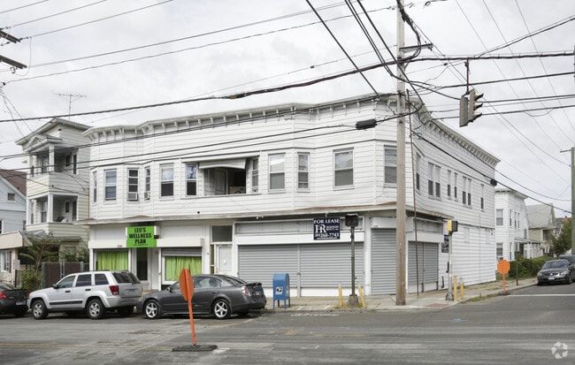
This Property Is For Sale
NEARBY LISTINGS FOR SALE OR LEASE
Property Detail
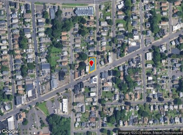
2336 Barnum Ave
STRA-000209-000003-000024
Fairfield
Commercialofficeresidentialmixeduse
Connecticut
X
24
09001C0434G
0.17 AC
2025
Trumbull/Upper Stratford/Shelton
2025
Westchester/So Connecticut
080100
Bridgeport-Stamford-Norwalk, CT
6,202 SF
DEMOGRAPHICS near 2336 Barnum Ave
1 Mile
3 Mile
5 Mile
2024 Total Population
30,033
143,405
256,927
2029 Population
30,139
142,966
257,375
Pop Growth 2024-2029
+ 0.35%
(0.31%)
+ 0.17%
Average Age
39
38
39
2024 Total Households
11,524
52,287
95,704
HH Growth 2024-2029
+ 0.46%
(0.35%)
+ 0.15%
Median Household Inc
$46,449
$55,475
$66,043
Avg Household Size
2.50
2.60
2.50
2024 Avg HH Vehicles
1.00
2.00
2.00
Median Home Value
$192,417
$247,249
$285,746
Median Year Built
1948
1949
1955
Nearby Places
- Restaurants
- Banks
- Shops
- Fitness
- Groceries
PUBLIC TRANSPORTATION
COMMUTER RAIL
Stratford Station (New Haven Line - Metro-North Commuter Railroad Company (Metro-North))
DRIVE
WALK
Distance
Stratford Station (New Haven Line - Metro-North Commuter Railroad Company (Metro-North))
7 min
2.5 mi
Bridgeport Station (New Haven Line - Metro-North Commuter Railroad Company (Metro-North))
DRIVE
WALK
Distance
Bridgeport Station (New Haven Line - Metro-North Commuter Railroad Company (Metro-North))
10 min
3.3 mi
AIRPORT
Westchester County
DRIVE
WALK
Distance
Westchester County
53 min
42.5 mi
Nearby Properties
Address
Land Use
TOTAL SIZE
Lot Size
Zoning
Address
Land Use
TOTAL SIZE
Lot Size
Zoning
Address
Land Use
TOTAL SIZE
Lot Size
Zoning
22.85 AC
Address
Land Use
TOTAL SIZE
Lot Size
Zoning
23.95 AC
RB
Address
Land Use
TOTAL SIZE
Lot Size
Zoning
145,000 SF
15.70 AC
ILI
Address
Land Use
TOTAL SIZE
Lot Size
Zoning
4.14 AC
MUEM
Address
Land Use
TOTAL SIZE
Lot Size
Zoning
178,265 SF
6.92 AC
Address
Land Use
TOTAL SIZE
Lot Size
Zoning
83,122 SF
4.39 AC
Address
Land Use
TOTAL SIZE
Lot Size
Zoning
288,875 SF
1.57 AC
MUEM
Address
Land Use
TOTAL SIZE
Lot Size
Zoning
497,430 SF
4.16 AC
DCB
Address
Land Use
TOTAL SIZE
Lot Size
Zoning
23 AC
RC
Address
Land Use
TOTAL SIZE
Lot Size
Zoning
162,376 SF
7.82 AC
Address
Land Use
TOTAL SIZE
Lot Size
Zoning
10.66 AC
ORR
Address
Land Use
TOTAL SIZE
Lot Size
Zoning
585,480 SF
3.66 AC
Address
Land Use
TOTAL SIZE
Lot Size
Zoning
493,114 SF
2.20 AC
DCB
Address
Land Use
TOTAL SIZE
Lot Size
Zoning
23.70 AC
RB
Address
Land Use
TOTAL SIZE
Lot Size
Zoning
92,318 SF
5.33 AC
Address
Land Use
TOTAL SIZE
Lot Size
Zoning
368,000 SF
18.69 AC
D-17
Address
Land Use
TOTAL SIZE
Lot Size
Zoning
216,972 SF
2.53 AC
DCB
Address
Land Use
TOTAL SIZE
Lot Size
Zoning
225,264 SF
28.22 AC
MC
Address
Land Use
TOTAL SIZE
Lot Size
Zoning
5.31 AC
RC
Address
Land Use
TOTAL SIZE
Lot Size
Zoning
204,000 SF
1.84 AC
MUEM
Address
Land Use
TOTAL SIZE
Lot Size
Zoning
110,506 SF
0.06 AC
RBB
Address
Land Use
TOTAL SIZE
Lot Size
Zoning
2.40 AC
DCB
Address
Land Use
TOTAL SIZE
Lot Size
Zoning
56,762 SF
13.34 AC
BZZ
Address
Land Use
TOTAL SIZE
Lot Size
Zoning
2 AC
DCB
Address
Land Use
TOTAL SIZE
Lot Size
Zoning
722 SF
47.10 AC
RM-1
Address
Land Use
TOTAL SIZE
Lot Size
Zoning
630 SF
107.70 AC
RA
Address
Land Use
TOTAL SIZE
Lot Size
Zoning
265,059 SF
47.61 AC
F-17
Address
Land Use
TOTAL SIZE
Lot Size
Zoning
90 AC
RA
Address
Land Use
TOTAL SIZE
Lot Size
Zoning
8.27 AC
C
The World's #1 Commercial Real Estate Marketplace
Connect with us
© 2025 CoStar Group
The information above has been obtained from sources believed reliable. While we do not doubt its accuracy we have not verified it and make no guarantee, warranty or representation about it. It is your responsibility to independently confirm its accuracy and completeness. Any projections, opinions, assumptions, or estimates used are for example only and do not represent the current or future performance of the property. The value of this transaction to you depends on tax and other factors which should be evaluated by your tax, financial, and legal advisors. You and your advisors should conduct a careful, independent investigation of the property to determine to your satisfaction the suitability of the property for your needs.