Property Record
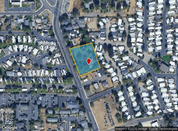
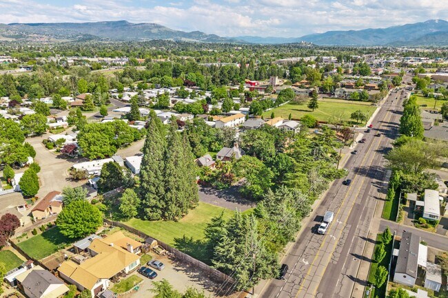
2336 Table Rock Rd, Medford, OR 97501

This Property Is For Sale
NEARBY LISTINGS FOR SALE OR LEASE
Property Detail
2336 Table Rock Rd
Sfr
Jackson
X
Oregon
41029C1957F
1.43 AC
2025
Medford/Grants Pass
2026
Other Market Areas
000300
Medford, OR
3,140 SF
10491986
DEMOGRAPHICS near 2336 Table Rock Rd
1 mile
3 mile
5 mile
2024 Total Population
9,851
77,885
116,001
2029 Population
9,824
77,305
115,428
Pop Growth 2024-2029
(0.27%)
(0.74%)
(0.49%)
Average Age
39
40
41
2024 Total Households
3,929
30,394
45,830
HH Growth 2024-2029
(0.23%)
(0.79%)
(0.55%)
Median Household Inc
$53,734
$59,865
$65,859
Avg Household Size
2.40
2.50
2.40
2024 Avg HH Vehicles
2.00
2.00
2.00
Median Home Value
$250,181
$318,089
$348,520
Median Year Built
1982
1979
1984
Nearby Places
Map Layers
Map Styles
 Street
 Aerial
Transit
 Traffic
 Biking
Places
Listings with unknown addresses are not visible on the map
- Restaurants
- Banks
- Shops
- Fitness
- Groceries
PUBLIC TRANSPORTATION
AIRPORT
Rogue Valley International - Medford
Drive
Walk
Distance
Rogue Valley International - Medford
4 min
1.8 mi
Nearby Properties
Address
Land Use
TOTAL SIZE
Lot Size
Zoning
Address
Land Use
TOTAL SIZE
Lot Size
Zoning
36,606 SF
2.20 AC
C-S/P
Address
Land Use
TOTAL SIZE
Lot Size
Zoning
290.83 AC
I-L
Address
Land Use
TOTAL SIZE
Lot Size
Zoning
249,867 SF
61.31 AC
SFR-4
Address
Land Use
TOTAL SIZE
Lot Size
Zoning
22.07 AC
GI
Address
Land Use
TOTAL SIZE
Lot Size
Zoning
196,384 SF
4.80 AC
C-S/P
Address
Land Use
TOTAL SIZE
Lot Size
Zoning
600,000 SF
18.27 AC
M-1
Address
Land Use
TOTAL SIZE
Lot Size
Zoning
77,354 SF
8.28 AC
SFR-4
Address
Land Use
TOTAL SIZE
Lot Size
Zoning
531,599 SF
26.34 AC
C-R
Address
Land Use
TOTAL SIZE
Lot Size
Zoning
153,140 SF
14.93 AC
SFR-10
Address
Land Use
TOTAL SIZE
Lot Size
Zoning
31.96 AC
GI
Address
Land Use
TOTAL SIZE
Lot Size
Zoning
177,106 SF
16.28 AC
C-C
Address
Land Use
TOTAL SIZE
Lot Size
Zoning
147,839 SF
15.43 AC
C-R
Address
Land Use
TOTAL SIZE
Lot Size
Zoning
176,910 SF
17.78 AC
C-R
Address
Land Use
TOTAL SIZE
Lot Size
Zoning
43.71 AC
GI
Address
Land Use
TOTAL SIZE
Lot Size
Zoning
11,180 SF
1.58 AC
MFR-20
Address
Land Use
TOTAL SIZE
Lot Size
Zoning
2,762 SF
6.81 AC
C-S/P
Address
Land Use
TOTAL SIZE
Lot Size
Zoning
85,610 SF
1.78 AC
C-C
Address
Land Use
TOTAL SIZE
Lot Size
Zoning
1,126 SF
4.89 AC
SFR-4
Address
Land Use
TOTAL SIZE
Lot Size
Zoning
88,434 SF
12.10 AC
I-L
Address
Land Use
TOTAL SIZE
Lot Size
Zoning
125,910 SF
14.29 AC
C-R
Address
Land Use
TOTAL SIZE
Lot Size
Zoning
30.87 AC
CIVIC
Address
Land Use
TOTAL SIZE
Lot Size
Zoning
3.54 AC
MFR-20
Address
Land Use
TOTAL SIZE
Lot Size
Zoning
6,140 SF
0.84 AC
C-C
Address
Land Use
TOTAL SIZE
Lot Size
Zoning
88.67 AC
I-L
Address
Land Use
TOTAL SIZE
Lot Size
Zoning
136,756 SF
12.50 AC
C-R
Address
Land Use
TOTAL SIZE
Lot Size
Zoning
245,754 SF
5.33 AC
MFR-30
Address
Land Use
TOTAL SIZE
Lot Size
Zoning
1,680 SF
43.61 AC
GI
Address
Land Use
TOTAL SIZE
Lot Size
Zoning
1,476 SF
5.52 AC
C-H
Address
Land Use
TOTAL SIZE
Lot Size
Zoning
109,042 SF
7.06 AC
C-R
Address
Land Use
TOTAL SIZE
Lot Size
Zoning
74,724 SF
7.56 AC
C-R
The World's #1 Commercial Real Estate Marketplace
Connect with us
© 2026 CoStar Group
The information above has been obtained from sources believed reliable. While we do not doubt its accuracy we have not verified it and make no guarantee, warranty or representation about it. It is your responsibility to independently confirm its accuracy and completeness. Any projections, opinions, assumptions, or estimates used are for example only and do not represent the current or future performance of the property. The value of this transaction to you depends on tax and other factors which should be evaluated by your tax, financial, and legal advisors. You and your advisors should conduct a careful, independent investigation of the property to determine to your satisfaction the suitability of the property for your needs.