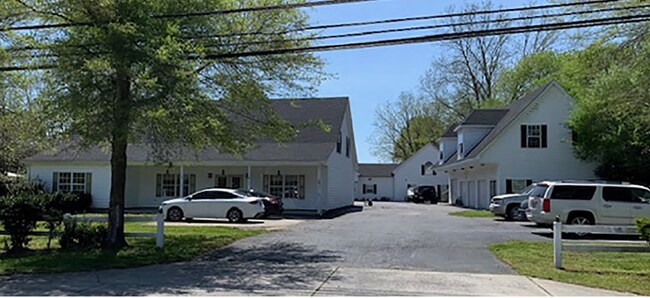
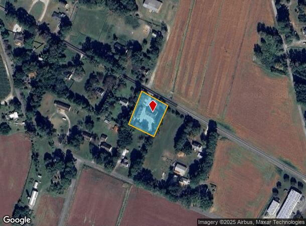
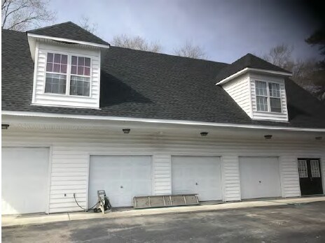
Property Record
2337 Mount Pleasant Rd, Chesapeake, VA 23322

NEARBY LISTINGS FOR SALE OR LEASE
-
-
View all Chesapeake listings for lease on LoopNet.com
Property Detail
2337 Mount Pleasant Rd
0510000000130
Battlefield South Corridor
Officebuilding
MT PLEASANT .9 AC
X
Chesapeake
5155310160G
Virginia
2024
0.90 AC
2025
Great Bridge
021103
Hampton Roads
4,684 SF
Virginia Beach-Chesapeake-Norfolk, VA-NC
DEMOGRAPHICS near 2337 Mount Pleasant Rd
1 Mile
3 Mile
5 Mile
2024 Total Population
275
5,828
62,211
2029 Population
281
5,913
62,469
Pop Growth 2024-2029
+ 2.18%
+ 1.46%
+ 0.41%
Average Age
41
39
40
2024 Total Households
91
1,830
20,529
HH Growth 2024-2029
+ 3.30%
+ 1.64%
+ 0.45%
Median Household Inc
$188,888
$144,520
$119,482
Avg Household Size
2.90
3.10
2.90
2024 Avg HH Vehicles
2.00
3.00
2.00
Median Home Value
$550,000
$463,692
$392,245
Median Year Built
1990
1996
1993
Nearby Places
Map Layers
Map Styles
 Street
 Aerial
- Restaurants
- Banks
- Shops
- Fitness
- Groceries
PUBLIC TRANSPORTATION
AIRPORT
Norfolk International
DRIVE
WALK
Distance
Norfolk International
33 min
19.2 mi
Freight Ports
Virginia Port Authority - Portsmouth
DRIVE
WALK
Distance
Virginia Port Authority - Portsmouth
31 min
20.9 mi
SALE & LEASE HISTORY
LISTING DATE
SALE/LEASE

Sep 25, 2016
For Lease
Feb 24, 2020
For Lease
Nearby Properties
Address
Land Use
TOTAL SIZE
Lot Size
Zoning
Address
Land Use
TOTAL SIZE
Lot Size
Zoning
2,592.19 AC
A1: AGRICU
Address
Land Use
TOTAL SIZE
Lot Size
Zoning
88,567 SF
15 AC
R15S: RESI
Address
Land Use
TOTAL SIZE
Lot Size
Zoning
24,004 SF
13.56 AC
R15S: RESI
Address
Land Use
TOTAL SIZE
Lot Size
Zoning
13,915 SF
5.46 AC
O-I: OFFIC
Address
Land Use
TOTAL SIZE
Lot Size
Zoning
8.26 AC
A1: AGRICU
Address
Land Use
TOTAL SIZE
Lot Size
Zoning
40,068 SF
11.98 AC
R15S: RESI
Address
Land Use
TOTAL SIZE
Lot Size
Zoning
26,513 SF
13.85 AC
AG1
Address
Land Use
TOTAL SIZE
Lot Size
Zoning
46,564 SF
5.51 AC
B2: GENERA
Address
Land Use
TOTAL SIZE
Lot Size
Zoning
1,680 SF
18.91 AC
M1: LIGHT
Address
Land Use
TOTAL SIZE
Lot Size
Zoning
18,939 SF
2.84 AC
B2: GENERA
Address
Land Use
TOTAL SIZE
Lot Size
Zoning
18,135 SF
6.69 AC
B2: GENERA
Address
Land Use
TOTAL SIZE
Lot Size
Zoning
39,868 SF
3.78 AC
B1: NEIGHB
Address
Land Use
TOTAL SIZE
Lot Size
Zoning
1,280 SF
25 AC
R15
Address
Land Use
TOTAL SIZE
Lot Size
Zoning
15,488 SF
4.97 AC
B2: GENERA
Address
Land Use
TOTAL SIZE
Lot Size
Zoning
14,563 SF
1.71 AC
B2: GENERA
Address
Land Use
TOTAL SIZE
Lot Size
Zoning
20,839 SF
0.01 AC
AG1
Address
Land Use
TOTAL SIZE
Lot Size
Zoning
912 SF
249.03 AC
A1: AGRICU
Address
Land Use
TOTAL SIZE
Lot Size
Zoning
7,240 SF
2.27 AC
A1: AGRICU
Address
Land Use
TOTAL SIZE
Lot Size
Zoning
1,914 SF
210.20 AC
A1: AGRICU
Address
Land Use
TOTAL SIZE
Lot Size
Zoning
5,904 SF
19.87 AC
AG2
Address
Land Use
TOTAL SIZE
Lot Size
Zoning
8,416 SF
0.97 AC
B2: GENERA
Address
Land Use
TOTAL SIZE
Lot Size
Zoning
21,116 SF
5.42 AC
A1: AGRICU
Address
Land Use
TOTAL SIZE
Lot Size
Zoning
8.95 AC
R15
Address
Land Use
TOTAL SIZE
Lot Size
Zoning
3,746 SF
1 AC
B2: GENERA
Address
Land Use
TOTAL SIZE
Lot Size
Zoning
1,539 SF
52.92 AC
B2
Address
Land Use
TOTAL SIZE
Lot Size
Zoning
572.33 AC
A1: AGRICU
Address
Land Use
TOTAL SIZE
Lot Size
Zoning
R15S: RESI
Address
Land Use
TOTAL SIZE
Lot Size
Zoning
13,125 SF
3 AC
A1: AGRICU
Address
Land Use
TOTAL SIZE
Lot Size
Zoning
214.35 AC
A1: AGRICU
Address
Land Use
TOTAL SIZE
Lot Size
Zoning
13 AC
O-I: OFFIC
The World's #1 Commercial Real Estate Marketplace
Connect with us
© 2026 CoStar Group
The information above has been obtained from sources believed reliable. While we do not doubt its accuracy we have not verified it and make no guarantee, warranty or representation about it. It is your responsibility to independently confirm its accuracy and completeness. Any projections, opinions, assumptions, or estimates used are for example only and do not represent the current or future performance of the property. The value of this transaction to you depends on tax and other factors which should be evaluated by your tax, financial, and legal advisors. You and your advisors should conduct a careful, independent investigation of the property to determine to your satisfaction the suitability of the property for your needs.