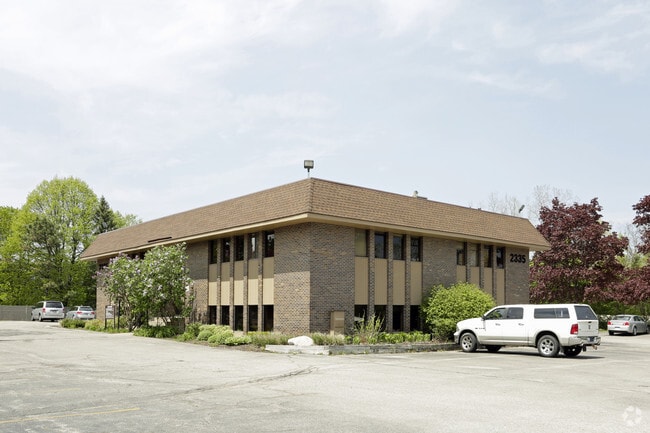
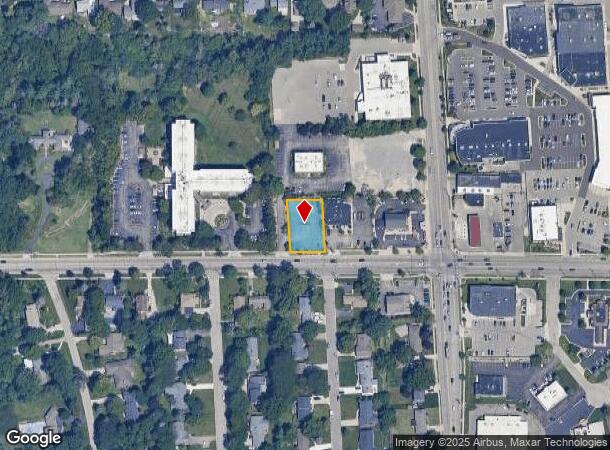
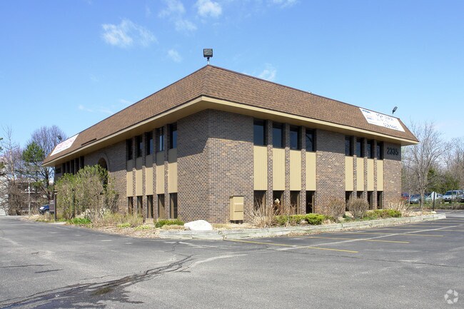
Property Record
2339 Burton St Se, Grand Rapids, MI 49506
NEARBY LISTINGS FOR SALE OR LEASE
Property Detail
2339 Burton St Se
41-18-04-477-022
THAT PART OF SE 1/4 OF SEC 4 T6N R11W COM ON CL OF BURTON ST 300 FT W OF W LINE OF BRETON RD TH N 190 FT PAR WITH W LINE OF
Commercialnec
Kent
X
Michigan
26081C0436D
0.35 AC
2024
Central Grand Rapids
2025
West Michigan
012400
Grand Rapids-Wyoming, MI
DEMOGRAPHICS near 2339 Burton St Se
1 Mile
3 Mile
5 Mile
2024 Total Population
15,407
108,066
256,233
2029 Population
15,462
108,537
257,797
Pop Growth 2024-2029
+ 0.36%
+ 0.44%
+ 0.61%
Average Age
38
37
37
2024 Total Households
5,732
41,328
98,948
HH Growth 2024-2029
+ 0.19%
+ 0.45%
+ 0.68%
Median Household Inc
$99,790
$67,459
$64,015
Avg Household Size
2.40
2.40
2.50
2024 Avg HH Vehicles
2.00
2.00
2.00
Median Home Value
$279,819
$244,236
$221,466
Median Year Built
1964
1959
1963
Nearby Places
Map Layers
Map Styles
 Street
 Aerial
- Restaurants
- Banks
- Shops
- Fitness
- Groceries
PUBLIC TRANSPORTATION
COMMUTER RAIL
DRIVE
WALK
Distance
11 min
5.4 mi
AIRPORT
Gerald R Ford International
DRIVE
WALK
Distance
Gerald R Ford International
17 min
7.9 mi
SALE & LEASE HISTORY
LISTING DATE
SALE/LEASE

Sep 24, 2016
For Lease
Sep 21, 2017
For Lease
Nearby Properties
Address
Land Use
TOTAL SIZE
Lot Size
Zoning
Address
Land Use
TOTAL SIZE
Lot Size
Zoning
563,998 SF
31.75 AC
C3
Address
Land Use
TOTAL SIZE
Lot Size
Zoning
385,631 SF
45.27 AC
R-PUD-1
Address
Land Use
TOTAL SIZE
Lot Size
Zoning
476,572 SF
51.60 AC
R4
Address
Land Use
TOTAL SIZE
Lot Size
Zoning
446,986 SF
72.57 AC
R4
Address
Land Use
TOTAL SIZE
Lot Size
Zoning
521,735 SF
52.16 AC
MON-C
Address
Land Use
TOTAL SIZE
Lot Size
Zoning
126,805 SF
9.36 AC
C4
Address
Land Use
TOTAL SIZE
Lot Size
Zoning
151,708 SF
7.22 AC
C4
Address
Land Use
TOTAL SIZE
Lot Size
Zoning
250,170 SF
16.13 AC
R-1
Address
Land Use
TOTAL SIZE
Lot Size
Zoning
211,760 SF
TN-CC
Address
Land Use
TOTAL SIZE
Lot Size
Zoning
341,808 SF
27.73 AC
HC-PUD
Address
Land Use
TOTAL SIZE
Lot Size
Zoning
223,931 SF
18 AC
R-PUD-1
Address
Land Use
TOTAL SIZE
Lot Size
Zoning
194,153 SF
15.84 AC
MCN-C
Address
Land Use
TOTAL SIZE
Lot Size
Zoning
27.25 AC
SD-PRD
Address
Land Use
TOTAL SIZE
Lot Size
Zoning
1,426,319 SF
54.81 AC
SD-IT
Address
Land Use
TOTAL SIZE
Lot Size
Zoning
22.46 AC
MON-MDR
Address
Land Use
TOTAL SIZE
Lot Size
Zoning
19.40 AC
MON-MDR
Address
Land Use
TOTAL SIZE
Lot Size
Zoning
127,141 SF
17.04 AC
C2
Address
Land Use
TOTAL SIZE
Lot Size
Zoning
138,278 SF
35.63 AC
R-1
Address
Land Use
TOTAL SIZE
Lot Size
Zoning
15.94 AC
MON-MDR
Address
Land Use
TOTAL SIZE
Lot Size
Zoning
97,263 SF
19.37 AC
MON-MDR
Address
Land Use
TOTAL SIZE
Lot Size
Zoning
13.71 AC
MCN-LDR
Address
Land Use
TOTAL SIZE
Lot Size
Zoning
16.91 AC
MON-MDR
Address
Land Use
TOTAL SIZE
Lot Size
Zoning
154,643 SF
10.96 AC
O-PUD
Address
Land Use
TOTAL SIZE
Lot Size
Zoning
146,732 SF
21.16 AC
R4
Address
Land Use
TOTAL SIZE
Lot Size
Zoning
153,571 SF
12.28 AC
SD-PRD
Address
Land Use
TOTAL SIZE
Lot Size
Zoning
258,128 SF
20.41 AC
R4
Address
Land Use
TOTAL SIZE
Lot Size
Zoning
183,583 SF
9.12 AC
R-1
Address
Land Use
TOTAL SIZE
Lot Size
Zoning
51,148 SF
26.38 AC
R-PUD-1
Address
Land Use
TOTAL SIZE
Lot Size
Zoning
17,671 SF
15.18 AC
MON-MDR
Address
Land Use
TOTAL SIZE
Lot Size
Zoning
536,296 SF
26.16 AC
SD-IT
The World's #1 Commercial Real Estate Marketplace
Connect with us
© 2025 CoStar Group
The information above has been obtained from sources believed reliable. While we do not doubt its accuracy we have not verified it and make no guarantee, warranty or representation about it. It is your responsibility to independently confirm its accuracy and completeness. Any projections, opinions, assumptions, or estimates used are for example only and do not represent the current or future performance of the property. The value of this transaction to you depends on tax and other factors which should be evaluated by your tax, financial, and legal advisors. You and your advisors should conduct a careful, independent investigation of the property to determine to your satisfaction the suitability of the property for your needs.