Property Record
234 S Hackett Rd, Waterloo, IA 50701
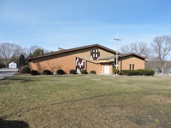


Property Detail
234 S Hackett Rd
8913-20-227-024
UNPLATTED WATERLOO WEST PART NE NE SEC 20 T 89 R 13 BEG AT NE COR SAID SEC TH S 672 FT TH W 191.74 FT TH TO RT ON A CURVE OF
Religious
Black Hawk
B and X Area of moderate flood hazard, usually the area between the limits of the 100-year and 500-year floods.
Iowa
2025
2.57 AC
2025
Iowa City/Waterloo
001503
Other Market Areas
3,370 SF
Waterloo-Cedar Falls, IA
NEARBY LISTINGS FOR SALE OR LEASE
-
-
View all Waterloo listings for sale on LoopNet.com
DEMOGRAPHICS near 234 S Hackett Rd
1 mile
3 mile
5 mile
2025 Total Population
5,675
42,256
101,425
2030 Population
5,708
42,846
103,088
Pop Growth 2025-2030
+ 0.58%
+ 1.40%
+ 1.64%
Average Age
42
39
38
2025 Total Households
2,658
18,405
42,147
HH Growth 2025-2030
+ 0.71%
+ 1.42%
+ 1.69%
Median Household Inc
$75,658
$57,271
$57,785
Avg Household Size
2.10
2.20
2.30
2025 Avg HH Vehicles
2.00
2.00
2.00
Median Home Value
$183,478
$178,996
$183,248
Median Year Built
1965
1962
1965
Nearby Places
Map Layers
Map Styles
 Street
 Aerial
Layers
 Traffic
 Biking
Places
Listings with unknown addresses are not visible on the map
- Restaurants
- Banks
- Shops
- Fitness
- Groceries
SALE & LEASE HISTORY
LISTING DATE
SALE/LEASE

Jun 07, 2017
For Sale
Feb 17, 2017
For Lease
Nearby Properties
Address
Land Use
TOTAL SIZE
Lot Size
Zoning
Address
Land Use
TOTAL SIZE
Lot Size
Zoning
9,719 SF
42.81 AC
Address
Land Use
TOTAL SIZE
Lot Size
Zoning
108,671 SF
3.72 AC
Address
Land Use
TOTAL SIZE
Lot Size
Zoning
88,541 SF
19.69 AC
Address
Land Use
TOTAL SIZE
Lot Size
Zoning
1,355.76 AC
Address
Land Use
TOTAL SIZE
Lot Size
Zoning
622 SF
106.81 AC
Address
Land Use
TOTAL SIZE
Lot Size
Zoning
341 SF
1.83 AC
Address
Land Use
TOTAL SIZE
Lot Size
Zoning
124,305 SF
4.74 AC
Address
Land Use
TOTAL SIZE
Lot Size
Zoning
91,112 SF
2.01 AC
Address
Land Use
TOTAL SIZE
Lot Size
Zoning
200,574 SF
17.52 AC
Address
Land Use
TOTAL SIZE
Lot Size
Zoning
212,928 SF
20.87 AC
Address
Land Use
TOTAL SIZE
Lot Size
Zoning
119,827 SF
7.77 AC
Address
Land Use
TOTAL SIZE
Lot Size
Zoning
9,000 SF
21.25 AC
Address
Land Use
TOTAL SIZE
Lot Size
Zoning
2,574 SF
15 AC
Address
Land Use
TOTAL SIZE
Lot Size
Zoning
49,360 SF
0.80 AC
Address
Land Use
TOTAL SIZE
Lot Size
Zoning
55,078 SF
1.39 AC
Address
Land Use
TOTAL SIZE
Lot Size
Zoning
8,000 SF
6.39 AC
Address
Land Use
TOTAL SIZE
Lot Size
Zoning
73,386 SF
2.02 AC
Address
Land Use
TOTAL SIZE
Lot Size
Zoning
1,600 SF
9.01 AC
Address
Land Use
TOTAL SIZE
Lot Size
Zoning
1,600 SF
28.74 AC
Address
Land Use
TOTAL SIZE
Lot Size
Zoning
11,828 SF
6.58 AC
Address
Land Use
TOTAL SIZE
Lot Size
Zoning
97,401 SF
21.83 AC
Address
Land Use
TOTAL SIZE
Lot Size
Zoning
42,844 SF
0.65 AC
Address
Land Use
TOTAL SIZE
Lot Size
Zoning
106,032 SF
8.22 AC
Address
Land Use
TOTAL SIZE
Lot Size
Zoning
60,275 SF
3.73 AC
Address
Land Use
TOTAL SIZE
Lot Size
Zoning
197,968 SF
6.10 AC
Address
Land Use
TOTAL SIZE
Lot Size
Zoning
300 SF
46 AC
Address
Land Use
TOTAL SIZE
Lot Size
Zoning
124,096 SF
16.46 AC
Address
Land Use
TOTAL SIZE
Lot Size
Zoning
18,000 SF
141.74 AC
Address
Land Use
TOTAL SIZE
Lot Size
Zoning
76,644 SF
13.11 AC
Address
Land Use
TOTAL SIZE
Lot Size
Zoning
105,224 SF
4.59 AC
The World's #1 Commercial Real Estate Marketplace
Connect with us
© 2026 CoStar Group
The information above has been obtained from sources believed reliable. While we do not doubt its accuracy we have not verified it and make no guarantee, warranty or representation about it. It is your responsibility to independently confirm its accuracy and completeness. Any projections, opinions, assumptions, or estimates used are for example only and do not represent the current or future performance of the property. The value of this transaction to you depends on tax and other factors which should be evaluated by your tax, financial, and legal advisors. You and your advisors should conduct a careful, independent investigation of the property to determine to your satisfaction the suitability of the property for your needs.