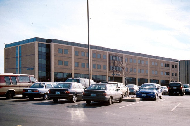
Property Record
2340 E Meyer Blvd, Kansas City, MO 64132


Current Lease Availabilities
NEARBY LISTINGS FOR SALE OR LEASE
Property Detail
2340 E Meyer Blvd
Kansas City, MO-KS
Research Medical Center
47-140-01-49-00-0-00-000
RESEARCH MEDICAL CENTER LOT 3
Officebuilding
Jackson
X
Missouri
29095C0268G
3
2024
3.91 AC
2025
Kansas City MO
008700
Kansas City
201,049 SF
DEMOGRAPHICS near 2340 E Meyer Blvd
1 Mile
3 Mile
5 Mile
2024 Total Population
11,946
88,521
239,541
2029 Population
12,148
89,274
243,204
Pop Growth 2024-2029
+ 1.69%
+ 0.85%
+ 1.53%
Average Age
40
39
39
2024 Total Households
5,047
38,930
109,198
HH Growth 2024-2029
+ 1.55%
+ 0.72%
+ 1.45%
Median Household Inc
$43,197
$63,480
$62,530
Avg Household Size
2.20
2.10
2.10
2024 Avg HH Vehicles
1.00
2.00
2.00
Median Home Value
$98,135
$241,867
$249,895
Median Year Built
1952
1949
1955
Nearby Places
Map Layers
Map Styles
 Street
 Aerial
- Restaurants
- Banks
- Shops
- Fitness
- Groceries
PUBLIC TRANSPORTATION
COMMUTER RAIL
Kansas City (Lincoln Service Missouri River Runner - Amtrak, Missouri River Runner - Amtrak, Southwest Chief - Amtrak)
DRIVE
WALK
Distance
Kansas City (Lincoln Service Missouri River Runner - Amtrak, Missouri River Runner - Amtrak, Southwest Chief - Amtrak)
13 min
7.0 mi
AIRPORT
Kansas City International
DRIVE
WALK
Distance
Kansas City International
38 min
27.2 mi
Freight Ports
Tulsa Port Of Catoosa
DRIVE
WALK
Distance
Tulsa Port Of Catoosa
264 min
234.5 mi
Nearby Properties
Address
Land Use
TOTAL SIZE
Lot Size
Zoning
Address
Land Use
TOTAL SIZE
Lot Size
Zoning
105,247 SF
0.72 AC
Address
Land Use
TOTAL SIZE
Lot Size
Zoning
543,241 SF
8.39 AC
Address
Land Use
TOTAL SIZE
Lot Size
Zoning
129,265 SF
1.17 AC
Address
Land Use
TOTAL SIZE
Lot Size
Zoning
149,157 SF
0.02 AC
URD
Address
Land Use
TOTAL SIZE
Lot Size
Zoning
379,472 SF
Address
Land Use
TOTAL SIZE
Lot Size
Zoning
369,624 SF
7.50 AC
Address
Land Use
TOTAL SIZE
Lot Size
Zoning
112,500 SF
26.32 AC
Address
Land Use
TOTAL SIZE
Lot Size
Zoning
193,643 SF
20.63 AC
Address
Land Use
TOTAL SIZE
Lot Size
Zoning
70,449 SF
0.66 AC
Address
Land Use
TOTAL SIZE
Lot Size
Zoning
174,983 SF
10.43 AC
Address
Land Use
TOTAL SIZE
Lot Size
Zoning
153,946 SF
5.91 AC
Address
Land Use
TOTAL SIZE
Lot Size
Zoning
785,016 SF
23.73 AC
Address
Land Use
TOTAL SIZE
Lot Size
Zoning
136,963 SF
2.05 AC
Address
Land Use
TOTAL SIZE
Lot Size
Zoning
213,914 SF
3.60 AC
Address
Land Use
TOTAL SIZE
Lot Size
Zoning
481,764 SF
26.50 AC
Address
Land Use
TOTAL SIZE
Lot Size
Zoning
205,182 SF
3.09 AC
Address
Land Use
TOTAL SIZE
Lot Size
Zoning
273,418 SF
1.97 AC
Address
Land Use
TOTAL SIZE
Lot Size
Zoning
82,299 SF
1.07 AC
Address
Land Use
TOTAL SIZE
Lot Size
Zoning
151,831 SF
12.93 AC
Address
Land Use
TOTAL SIZE
Lot Size
Zoning
59,590 SF
2.19 AC
Address
Land Use
TOTAL SIZE
Lot Size
Zoning
176,703 SF
1.43 AC
Address
Land Use
TOTAL SIZE
Lot Size
Zoning
136,963 SF
0.66 AC
Address
Land Use
TOTAL SIZE
Lot Size
Zoning
252,545 SF
1.99 AC
Address
Land Use
TOTAL SIZE
Lot Size
Zoning
194,371 SF
12.94 AC
R2A
Address
Land Use
TOTAL SIZE
Lot Size
Zoning
107,058 SF
2.28 AC
Address
Land Use
TOTAL SIZE
Lot Size
Zoning
42,333 SF
0.38 AC
Address
Land Use
TOTAL SIZE
Lot Size
Zoning
33,307 SF
16.11 AC
Address
Land Use
TOTAL SIZE
Lot Size
Zoning
423,342 SF
13 AC
Address
Land Use
TOTAL SIZE
Lot Size
Zoning
119,787 SF
3.60 AC
Address
Land Use
TOTAL SIZE
Lot Size
Zoning
364,554 SF
22 AC
The World's #1 Commercial Real Estate Marketplace
Connect with us
© 2026 CoStar Group
The information above has been obtained from sources believed reliable. While we do not doubt its accuracy we have not verified it and make no guarantee, warranty or representation about it. It is your responsibility to independently confirm its accuracy and completeness. Any projections, opinions, assumptions, or estimates used are for example only and do not represent the current or future performance of the property. The value of this transaction to you depends on tax and other factors which should be evaluated by your tax, financial, and legal advisors. You and your advisors should conduct a careful, independent investigation of the property to determine to your satisfaction the suitability of the property for your needs.