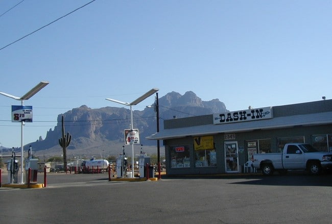
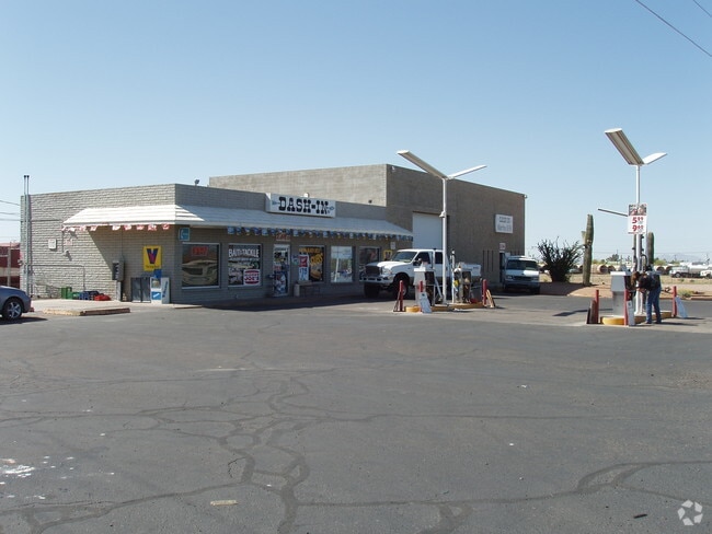
Property Record
2341 N Apache Trl, Apache Junction, AZ 85119

Property Detail
2341 N Apache Trl
Phoenix-Mesa-Chandler, AZ
COMMENCING AT THE NORTHEAST CORNER OF THE NORTHWEST QUARTER OF SE CTION 15, TOWNSHIP 01 NORTH, RANGE 08 EAST, THENCE W-40.00 FT TO THE POINT OF BEGINNING THENCE S-212.98 FT THENCE S70D W-203.75 FT THENCE S-61.12 FT THENCE W-37.52 FT THENCE N87D W-168
100-25-043C
PINAL
Bartavern
Arizona
B and X Area of moderate flood hazard, usually the area between the limits of the 100-year and 500-year floods.
1
2024
2.94 AC
2025
Apache Junction
000310
Phoenix
4,660 SF
NEARBY LISTINGS FOR SALE OR LEASE
DEMOGRAPHICS near 2341 N Apache Trl
1 mile
3 mile
5 mile
2025 Total Population
722
22,557
72,980
2030 Population
837
26,107
83,489
Pop Growth 2025-2030
+ 15.93%
+ 15.74%
+ 14.40%
Average Age
47
48
48
2025 Total Households
299
10,081
31,903
HH Growth 2025-2030
+ 15.72%
+ 15.46%
+ 14.73%
Median Household Inc
$62,264
$61,807
$64,188
Avg Household Size
2.30
2.20
2.20
2025 Avg HH Vehicles
2.00
2.00
2.00
Median Home Value
$399,999
$363,968
$316,227
Median Year Built
1984
1989
1994
Nearby Places
Map Layers
Map Styles
 Street
 Aerial
Transit
 Traffic
 Biking
Places
Listings with unknown addresses are not visible on the map
- Restaurants
- Banks
- Shops
- Fitness
- Groceries
PUBLIC TRANSPORTATION
AIRPORT
Phoenix-Mesa Gateway
Drive
Walk
Distance
Phoenix-Mesa Gateway
28 min
18.4 mi
Phoenix Sky Harbor International
Drive
Walk
Distance
Phoenix Sky Harbor International
43 min
31.0 mi
Freight Ports
Port of San Diego
Drive
Walk
Distance
Port of San Diego
433 min
391.0 mi
Nearby Properties
Address
Land Use
TOTAL SIZE
Lot Size
Zoning
Address
Land Use
TOTAL SIZE
Lot Size
Zoning
117,169 SF
13.27 AC
Address
Land Use
TOTAL SIZE
Lot Size
Zoning
Address
Land Use
TOTAL SIZE
Lot Size
Zoning
291.97 AC
Address
Land Use
TOTAL SIZE
Lot Size
Zoning
108,644 SF
10.12 AC
UNDESIGNAT
Address
Land Use
TOTAL SIZE
Lot Size
Zoning
62,290 SF
7.53 AC
UNDESIGNAT
Address
Land Use
TOTAL SIZE
Lot Size
Zoning
69,692 SF
7.26 AC
Address
Land Use
TOTAL SIZE
Lot Size
Zoning
11,686 SF
40 AC
Address
Land Use
TOTAL SIZE
Lot Size
Zoning
23,180 SF
3.90 AC
UNDESIGNAT
Address
Land Use
TOTAL SIZE
Lot Size
Zoning
26,022 SF
11.03 AC
UNDESIGNAT
Address
Land Use
TOTAL SIZE
Lot Size
Zoning
54,300 SF
4.57 AC
UNDESIGNAT
Address
Land Use
TOTAL SIZE
Lot Size
Zoning
683 SF
36.74 AC
UNDESIGNAT
Address
Land Use
TOTAL SIZE
Lot Size
Zoning
24,158 SF
5.19 AC
Address
Land Use
TOTAL SIZE
Lot Size
Zoning
30,477 SF
3.91 AC
UNDESIGNAT
Address
Land Use
TOTAL SIZE
Lot Size
Zoning
54,784 SF
5.36 AC
Address
Land Use
TOTAL SIZE
Lot Size
Zoning
34,441 SF
4.62 AC
UNDESIGNAT
Address
Land Use
TOTAL SIZE
Lot Size
Zoning
21,547 SF
4.25 AC
UNDESIGNAT
Address
Land Use
TOTAL SIZE
Lot Size
Zoning
19,977 SF
2.93 AC
UNDESIGNAT
Address
Land Use
TOTAL SIZE
Lot Size
Zoning
26,586 SF
4.51 AC
Address
Land Use
TOTAL SIZE
Lot Size
Zoning
20,123 SF
1 AC
UNDESIGNAT
Address
Land Use
TOTAL SIZE
Lot Size
Zoning
77,730 SF
6.15 AC
Address
Land Use
TOTAL SIZE
Lot Size
Zoning
23,349 SF
2.26 AC
Address
Land Use
TOTAL SIZE
Lot Size
Zoning
3,516 SF
18.82 AC
UNDESIGNAT
Address
Land Use
TOTAL SIZE
Lot Size
Zoning
15,866 SF
2.40 AC
UNDESIGNAT
Address
Land Use
TOTAL SIZE
Lot Size
Zoning
16,580 SF
4.05 AC
UNDESIGNAT
Address
Land Use
TOTAL SIZE
Lot Size
Zoning
593 SF
18.92 AC
UNDESIGNAT
Address
Land Use
TOTAL SIZE
Lot Size
Zoning
15,143 SF
1.69 AC
UNDESIGNAT
Address
Land Use
TOTAL SIZE
Lot Size
Zoning
26,362 SF
4.99 AC
UNDESIGNAT
Address
Land Use
TOTAL SIZE
Lot Size
Zoning
14,000 SF
1.76 AC
The World's #1 Commercial Real Estate Marketplace
Connect with us
© 2026 CoStar Group
The information above has been obtained from sources believed reliable. While we do not doubt its accuracy we have not verified it and make no guarantee, warranty or representation about it. It is your responsibility to independently confirm its accuracy and completeness. Any projections, opinions, assumptions, or estimates used are for example only and do not represent the current or future performance of the property. The value of this transaction to you depends on tax and other factors which should be evaluated by your tax, financial, and legal advisors. You and your advisors should conduct a careful, independent investigation of the property to determine to your satisfaction the suitability of the property for your needs.