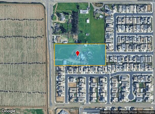
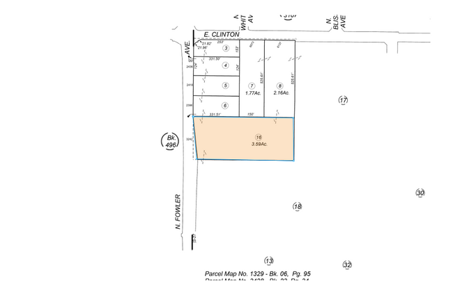
Property Record
2342 N Fowler Ave, Fresno, CA 93727
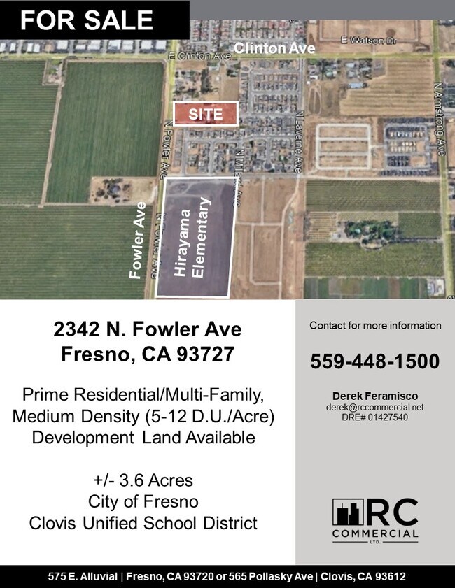
This Property Is For Sale
NEARBY LISTINGS FOR SALE OR LEASE
Property Detail
2342 N Fowler Ave
Fresno, CA
Fresno
574-050-16
California
Sfr
3.51 AC
X
E Outlying Fresno County
06019C1595H
Fresno
1,483 SF
DEMOGRAPHICS near 2342 N Fowler Ave
1 Mile
3 Mile
5 Mile
2024 Total Population
8,525
99,228
284,278
2029 Population
9,068
102,208
291,433
Pop Growth 2024-2029
+ 6.37%
+ 3.00%
+ 2.52%
Average Age
34
35
35
2024 Total Households
2,420
31,057
89,613
HH Growth 2024-2029
+ 6.36%
+ 2.96%
+ 2.54%
Median Household Inc
$113,749
$78,795
$64,380
Avg Household Size
3.40
3.10
3.10
2024 Avg HH Vehicles
2.00
2.00
2.00
Median Home Value
$391,702
$362,083
$331,798
Median Year Built
2010
1986
1979
Nearby Places
Map Layers
Map Styles
 Street
 Aerial
- Restaurants
- Banks
- Shops
- Fitness
- Groceries
PUBLIC TRANSPORTATION
COMMUTER RAIL
Fresno (San Joaquins - Amtrak)
DRIVE
WALK
Distance
Fresno (San Joaquins - Amtrak)
11 min
7.6 mi
AIRPORT
Fresno Yosemite International
DRIVE
WALK
Distance
Fresno Yosemite International
8 min
4.1 mi
Freight Ports
Port of Stockton
DRIVE
WALK
Distance
Port of Stockton
160 min
134.6 mi
Nearby Properties
Address
Land Use
TOTAL SIZE
Lot Size
Zoning
Address
Land Use
TOTAL SIZE
Lot Size
Zoning
1,081,456 SF
113.56 AC
M1
Address
Land Use
TOTAL SIZE
Lot Size
Zoning
794,471 SF
73.71 AC
Address
Land Use
TOTAL SIZE
Lot Size
Zoning
74,499 SF
17.48 AC
M3
Address
Land Use
TOTAL SIZE
Lot Size
Zoning
2,008 SF
20.14 AC
M1
Address
Land Use
TOTAL SIZE
Lot Size
Zoning
202,149 SF
27.56 AC
SPLIT
Address
Land Use
TOTAL SIZE
Lot Size
Zoning
216,342 SF
28.49 AC
Address
Land Use
TOTAL SIZE
Lot Size
Zoning
385,529 SF
29.36 AC
R2
Address
Land Use
TOTAL SIZE
Lot Size
Zoning
268,956 SF
13.25 AC
R3
Address
Land Use
TOTAL SIZE
Lot Size
Zoning
249,818 SF
12.24 AC
PCC
Address
Land Use
TOTAL SIZE
Lot Size
Zoning
372,862 SF
42.43 AC
R1
Address
Land Use
TOTAL SIZE
Lot Size
Zoning
60,227 SF
4.72 AC
M1
Address
Land Use
TOTAL SIZE
Lot Size
Zoning
91,715 SF
4.50 AC
R3
Address
Land Use
TOTAL SIZE
Lot Size
Zoning
94,584 SF
10.93 AC
M1
Address
Land Use
TOTAL SIZE
Lot Size
Zoning
152,918 SF
15.85 AC
C2
Address
Land Use
TOTAL SIZE
Lot Size
Zoning
93,172 SF
4.97 AC
Address
Land Use
TOTAL SIZE
Lot Size
Zoning
86,678 SF
4.16 AC
CP
Address
Land Use
TOTAL SIZE
Lot Size
Zoning
249,126 SF
17.33 AC
SPLIT
Address
Land Use
TOTAL SIZE
Lot Size
Zoning
83,458 SF
2.66 AC
PCC
Address
Land Use
TOTAL SIZE
Lot Size
Zoning
250,412 SF
16.09 AC
RM3
Address
Land Use
TOTAL SIZE
Lot Size
Zoning
190,006 SF
19.35 AC
RM1
Address
Land Use
TOTAL SIZE
Lot Size
Zoning
102,765 SF
8.90 AC
M1
Address
Land Use
TOTAL SIZE
Lot Size
Zoning
151,980 SF
4.94 AC
CM
Address
Land Use
TOTAL SIZE
Lot Size
Zoning
138,502 SF
3.46 AC
C2
Address
Land Use
TOTAL SIZE
Lot Size
Zoning
57,695 SF
4.99 AC
R2A
Address
Land Use
TOTAL SIZE
Lot Size
Zoning
401,192 SF
0.01 AC
PCC
Address
Land Use
TOTAL SIZE
Lot Size
Zoning
226,937 SF
20.15 AC
SPLIT
Address
Land Use
TOTAL SIZE
Lot Size
Zoning
171,783 SF
8.30 AC
M1
Address
Land Use
TOTAL SIZE
Lot Size
Zoning
226,937 SF
11.52 AC
Address
Land Use
TOTAL SIZE
Lot Size
Zoning
67,659 SF
2.66 AC
PCC
The World's #1 Commercial Real Estate Marketplace
Connect with us
© 2025 CoStar Group
The information above has been obtained from sources believed reliable. While we do not doubt its accuracy we have not verified it and make no guarantee, warranty or representation about it. It is your responsibility to independently confirm its accuracy and completeness. Any projections, opinions, assumptions, or estimates used are for example only and do not represent the current or future performance of the property. The value of this transaction to you depends on tax and other factors which should be evaluated by your tax, financial, and legal advisors. You and your advisors should conduct a careful, independent investigation of the property to determine to your satisfaction the suitability of the property for your needs.