Property Record
2345 Route 16, Ossipee, NH 03864
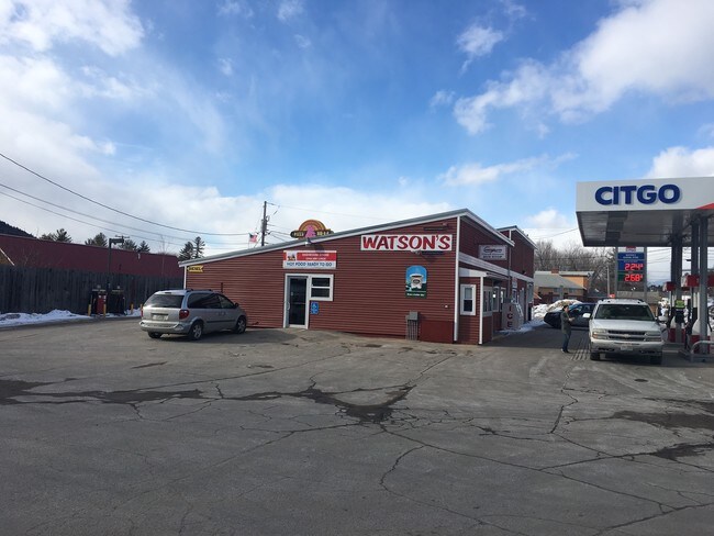

Property Detail
2345 Route 16
Commercialbuilding
CARROLL
RSC
New Hampshire
AE The base floodplain where base flood elevations are provided. AE Zones are now used on new format FIRMs instead of A1-A30 Zones.
5000
2025
0.63 AC
2025
Concord/New Hampshire North Area
955902
Other Market Areas
3,962 SF
OSSI-000009-000000-005000
NEARBY LISTINGS FOR SALE OR LEASE
-
-
View all Ossipee listings for lease on LoopNet.com
DEMOGRAPHICS near 2345 Route 16
1 mile
3 mile
5 mile
2025 Total Population
359
2,341
5,441
2030 Population
384
2,369
5,585
Pop Growth 2025-2030
+ 6.96%
+ 1.20%
+ 2.65%
Average Age
51
49
50
2025 Total Households
173
1,090
2,611
HH Growth 2025-2030
+ 6.94%
+ 1.28%
+ 3.10%
Median Household Inc
$104,167
$81,843
$72,734
Avg Household Size
2.10
2.10
2.00
2025 Avg HH Vehicles
2.00
2.00
2.00
Median Home Value
$391,345
$385,795
$389,981
Median Year Built
1982
1980
1983
Nearby Places
Map Layers
Map Styles
 Street
 Aerial
Layers
 Traffic
 Biking
Places
Listings with unknown addresses are not visible on the map
- Restaurants
- Banks
- Shops
- Fitness
- Groceries
SALE & LEASE HISTORY
LISTING DATE
SALE/LEASE

Jul 13, 2017
For Sale
Apr 11, 2018
For Lease
Nearby Properties
Address
Land Use
TOTAL SIZE
Lot Size
Zoning
Address
Land Use
TOTAL SIZE
Lot Size
Zoning
390.81 AC
RUR OS
Address
Land Use
TOTAL SIZE
Lot Size
Zoning
4,197 SF
30.10 AC
OSSIPE
Address
Land Use
TOTAL SIZE
Lot Size
Zoning
26.90 AC
TAMWOR
Address
Land Use
TOTAL SIZE
Lot Size
Zoning
1,001 SF
25.80 AC
OSSIPE
Address
Land Use
TOTAL SIZE
Lot Size
Zoning
2,022 SF
51.77 AC
COMMER
Address
Land Use
TOTAL SIZE
Lot Size
Zoning
3,812 SF
10.74 AC
OSSIPE
Address
Land Use
TOTAL SIZE
Lot Size
Zoning
1,628 SF
902.70 AC
TAMWOR
Address
Land Use
TOTAL SIZE
Lot Size
Zoning
13,017 SF
116.50 AC
GENERA
Address
Land Use
TOTAL SIZE
Lot Size
Zoning
22,103 SF
5.59 AC
COM
Address
Land Use
TOTAL SIZE
Lot Size
Zoning
19,271 SF
8 AC
RSC
Address
Land Use
TOTAL SIZE
Lot Size
Zoning
15,257 SF
3.50 AC
RSC
Address
Land Use
TOTAL SIZE
Lot Size
Zoning
1,911 SF
2.64 AC
RURAL
Address
Land Use
TOTAL SIZE
Lot Size
Zoning
6,129 SF
29.50 AC
RUR
Address
Land Use
TOTAL SIZE
Lot Size
Zoning
11,220 SF
2.40 AC
COM
Address
Land Use
TOTAL SIZE
Lot Size
Zoning
1,298 SF
2.86 AC
TAMWOR
Address
Land Use
TOTAL SIZE
Lot Size
Zoning
1,720 SF
186.40 AC
TAMWOR
Address
Land Use
TOTAL SIZE
Lot Size
Zoning
1,376 SF
1 AC
RURAL
Address
Land Use
TOTAL SIZE
Lot Size
Zoning
4,340 SF
0.97 AC
OSSIPE
Address
Land Use
TOTAL SIZE
Lot Size
Zoning
38 AC
TAMWOR
Address
Land Use
TOTAL SIZE
Lot Size
Zoning
1,744 SF
1.10 AC
RURAL
Address
Land Use
TOTAL SIZE
Lot Size
Zoning
1.50 AC
RURAL
Address
Land Use
TOTAL SIZE
Lot Size
Zoning
1,299 SF
0.50 AC
RURAL
Address
Land Use
TOTAL SIZE
Lot Size
Zoning
2,301 SF
3.06 AC
OSSIPE
Address
Land Use
TOTAL SIZE
Lot Size
Zoning
1,387 SF
0.75 AC
RURAL
Address
Land Use
TOTAL SIZE
Lot Size
Zoning
0.59 AC
TAMWOR
Address
Land Use
TOTAL SIZE
Lot Size
Zoning
28,588 SF
2.50 AC
TAMWOR
Address
Land Use
TOTAL SIZE
Lot Size
Zoning
3,000 SF
5.34 AC
TAMWOR
Address
Land Use
TOTAL SIZE
Lot Size
Zoning
5,089 SF
9.91 AC
TAMWOR
Address
Land Use
TOTAL SIZE
Lot Size
Zoning
0.61 AC
RURAL
Address
Land Use
TOTAL SIZE
Lot Size
Zoning
927 SF
5.17 AC
TAMWOR
The World's #1 Commercial Real Estate Marketplace
Connect with us
© 2026 CoStar Group
The information above has been obtained from sources believed reliable. While we do not doubt its accuracy we have not verified it and make no guarantee, warranty or representation about it. It is your responsibility to independently confirm its accuracy and completeness. Any projections, opinions, assumptions, or estimates used are for example only and do not represent the current or future performance of the property. The value of this transaction to you depends on tax and other factors which should be evaluated by your tax, financial, and legal advisors. You and your advisors should conduct a careful, independent investigation of the property to determine to your satisfaction the suitability of the property for your needs.