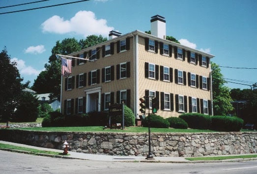
Property Record
2345 Washington St, Newton Lower Falls, MA 02462

NEARBY LISTINGS FOR SALE OR LEASE
Property Detail
2345 Washington St
NEWT-000042-000030-000008
Middlesex
Officebuilding
Massachusetts
X
8
25021C0009F
0.28 AC
2025
Newton/Brookline
2025
Boston
374800
Boston-Cambridge-Newton, MA-NH
5,700 SF
DEMOGRAPHICS near 2345 Washington St
1 Mile
3 Mile
5 Mile
2024 Total Population
9,224
89,195
238,923
2029 Population
9,231
88,687
236,527
Pop Growth 2024-2029
+ 0.08%
(0.57%)
(1.00%)
Average Age
42
41
41
2024 Total Households
3,167
31,655
88,599
HH Growth 2024-2029
+ 0.06%
(0.65%)
(1.13%)
Median Household Inc
$228,548
$182,171
$149,538
Avg Household Size
2.80
2.60
2.50
2024 Avg HH Vehicles
2.00
2.00
2.00
Median Home Value
$1,107,349
$1,057,705
$986,636
Median Year Built
1951
1952
1953
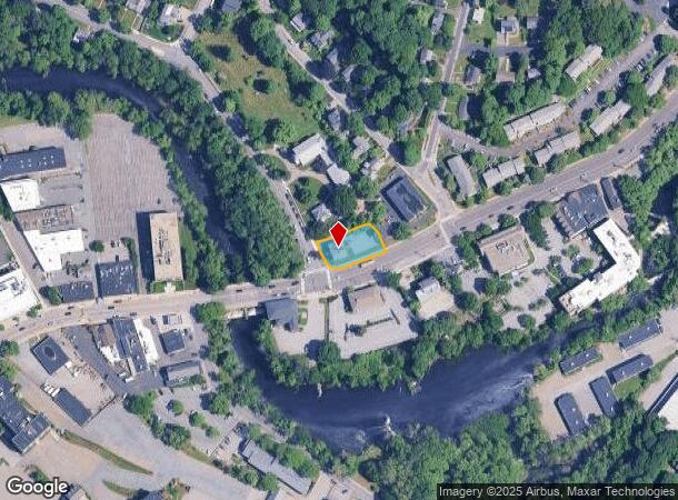
Nearby Places
Map Layers
Map Styles
 Street
 Aerial
- Restaurants
- Banks
- Shops
- Fitness
- Groceries
PUBLIC TRANSPORTATION
TRANSIT/SUBWAY
Wellesley Farms (Framingham/Worcester Line - Massachusetts Bay Transportation Authority Commuter Rail (Purple Line))
DRIVE
WALK
Distance
Wellesley Farms (Framingham/Worcester Line - Massachusetts Bay Transportation Authority Commuter Rail (Purple Line))
2 min
16 min
0.8 mi
Woodland Station (Green Line - D - Massachusetts Bay Transportation Authority Subway (The T))
DRIVE
WALK
Distance
Woodland Station (Green Line - D - Massachusetts Bay Transportation Authority Subway (The T))
2 min
20 min
1.0 mi
Riverside Station (Green Line - D - Massachusetts Bay Transportation Authority Subway (The T))
DRIVE
WALK
Distance
Riverside Station (Green Line - D - Massachusetts Bay Transportation Authority Subway (The T))
4 min
20 min
1.0 mi
COMMUTER RAIL
Wellesley Farms (Framingham/Worcester Line - Massachusetts Bay Transportation Authority Commuter Rail (Purple Line))
DRIVE
WALK
Distance
Wellesley Farms (Framingham/Worcester Line - Massachusetts Bay Transportation Authority Commuter Rail (Purple Line))
2 min
16 min
0.8 mi
Wellesley Hills (Framingham/Worcester Line - Massachusetts Bay Transportation Authority Commuter Rail (Purple Line))
DRIVE
WALK
Distance
Wellesley Hills (Framingham/Worcester Line - Massachusetts Bay Transportation Authority Commuter Rail (Purple Line))
3 min
1.5 mi
AIRPORT
General Edward Lawrence Logan International
DRIVE
WALK
Distance
General Edward Lawrence Logan International
24 min
15.0 mi
Worcester Regional
DRIVE
WALK
Distance
Worcester Regional
56 min
39.0 mi
Freight Ports
Port of Boston
DRIVE
WALK
Distance
Port of Boston
23 min
13.3 mi
SALE & LEASE HISTORY
LISTING DATE
SALE/LEASE

Oct 02, 2017
For Lease
Mar 30, 2018
For Lease
Mar 30, 2017
For Lease
Jan 31, 2017
For Lease
Nearby Properties
Address
Land Use
TOTAL SIZE
Lot Size
Zoning
Address
Land Use
TOTAL SIZE
Lot Size
Zoning
387,550 SF
7.99 AC
MU1
Address
Land Use
TOTAL SIZE
Lot Size
Zoning
412,208 SF
7.93 AC
I
Address
Land Use
TOTAL SIZE
Lot Size
Zoning
522,600 SF
59.54 AC
A2
Address
Land Use
TOTAL SIZE
Lot Size
Zoning
10.87 AC
SRD 10
Address
Land Use
TOTAL SIZE
Lot Size
Zoning
4.74 AC
NEBC
Address
Land Use
TOTAL SIZE
Lot Size
Zoning
76,800 SF
22.65 AC
MU1
Address
Land Use
TOTAL SIZE
Lot Size
Zoning
15,974 SF
2.45 AC
ED
Address
Land Use
TOTAL SIZE
Lot Size
Zoning
220,500 SF
1.96 AC
NEBC
Address
Land Use
TOTAL SIZE
Lot Size
Zoning
293,195 SF
11.55 AC
BU5
Address
Land Use
TOTAL SIZE
Lot Size
Zoning
391,781 SF
8.22 AC
Address
Land Use
TOTAL SIZE
Lot Size
Zoning
3.86 AC
Address
Land Use
TOTAL SIZE
Lot Size
Zoning
6.33 AC
SR10
Address
Land Use
TOTAL SIZE
Lot Size
Zoning
189,858 SF
61.45 AC
A
Address
Land Use
TOTAL SIZE
Lot Size
Zoning
Address
Land Use
TOTAL SIZE
Lot Size
Zoning
Address
Land Use
TOTAL SIZE
Lot Size
Zoning
144,584 SF
4.86 AC
PUB
Address
Land Use
TOTAL SIZE
Lot Size
Zoning
264,014 SF
10.64 AC
NEBC
Address
Land Use
TOTAL SIZE
Lot Size
Zoning
179,963 SF
41.28 AC
A
Address
Land Use
TOTAL SIZE
Lot Size
Zoning
15.60 AC
Address
Land Use
TOTAL SIZE
Lot Size
Zoning
30,027 SF
96.45 AC
ORD
Address
Land Use
TOTAL SIZE
Lot Size
Zoning
80,447 SF
6.52 AC
PUB
Address
Land Use
TOTAL SIZE
Lot Size
Zoning
15.08 AC
SR10
Address
Land Use
TOTAL SIZE
Lot Size
Zoning
203,738 SF
6.94 AC
Address
Land Use
TOTAL SIZE
Lot Size
Zoning
84.78 AC
Address
Land Use
TOTAL SIZE
Lot Size
Zoning
2,537 SF
14.43 AC
SR3
Address
Land Use
TOTAL SIZE
Lot Size
Zoning
408,199 SF
23.35 AC
NEBC
Address
Land Use
TOTAL SIZE
Lot Size
Zoning
1,683 SF
46.10 AC
SR15
Address
Land Use
TOTAL SIZE
Lot Size
Zoning
211,500 SF
12.09 AC
I
Address
Land Use
TOTAL SIZE
Lot Size
Zoning
Address
Land Use
TOTAL SIZE
Lot Size
Zoning
49.88 AC
T
The World's #1 Commercial Real Estate Marketplace
Connect with us
© 2025 CoStar Group
The information above has been obtained from sources believed reliable. While we do not doubt its accuracy we have not verified it and make no guarantee, warranty or representation about it. It is your responsibility to independently confirm its accuracy and completeness. Any projections, opinions, assumptions, or estimates used are for example only and do not represent the current or future performance of the property. The value of this transaction to you depends on tax and other factors which should be evaluated by your tax, financial, and legal advisors. You and your advisors should conduct a careful, independent investigation of the property to determine to your satisfaction the suitability of the property for your needs.