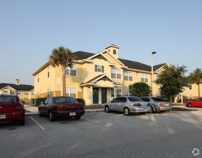
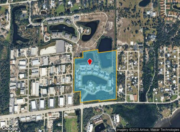
Property Record
23450 Charleston Cir, Punta Gorda, FL 33980

NEARBY LISTINGS FOR SALE OR LEASE
Property Detail
23450 Charleston Cir
402225278002
25 40 22 PARCEL 1-1-4 25.54 AC. M/L COMM AT NEW COR OF NE 1/4 SEC 25 TH S 35.43 FT TO S ROW WESTCHESTER BLVD TH E 500.43 FT TO W LN WHIDDEN ACRES TH S 365.26 FT E 2030.15 FT TO SE COR WHIDDEN ACRES S 932.68 FT CONT S 99.99 FT FOR POB TH CONT S
Multifamilydwelling
Charlotte
AE
Florida
12015C0233G
25.54 AC
2024
Port Charlotte
2025
Southwest Florida
021003
Punta Gorda, FL
138,220 SF
DEMOGRAPHICS near 23450 Charleston Cir
1 Mile
3 Mile
5 Mile
2024 Total Population
4,100
35,621
100,975
2029 Population
4,958
42,714
120,683
Pop Growth 2024-2029
+ 20.93%
+ 19.91%
+ 19.52%
Average Age
54
51
52
2024 Total Households
2,068
16,392
46,531
HH Growth 2024-2029
+ 21.37%
+ 20.35%
+ 19.86%
Median Household Inc
$48,764
$49,392
$56,970
Avg Household Size
1.90
2.10
2.10
2024 Avg HH Vehicles
1.00
2.00
2.00
Median Home Value
$183,292
$197,065
$244,484
Median Year Built
1985
1982
1986
Nearby Places
Map Layers
Map Styles
 Street
 Aerial
- Restaurants
- Banks
- Shops
- Fitness
- Groceries
PUBLIC TRANSPORTATION
AIRPORT
Punta Gorda
DRIVE
WALK
Distance
Punta Gorda
15 min
7.2 mi
Freight Ports
Port Manatee
DRIVE
WALK
Distance
Port Manatee
84 min
70.3 mi
Nearby Properties
Address
Land Use
TOTAL SIZE
Lot Size
Zoning
Address
Land Use
TOTAL SIZE
Lot Size
Zoning
333,027 SF
9.79 AC
CHRW
Address
Land Use
TOTAL SIZE
Lot Size
Zoning
156,350 SF
12.49 AC
OMI
Address
Land Use
TOTAL SIZE
Lot Size
Zoning
129,475 SF
16.04 AC
OMI
Address
Land Use
TOTAL SIZE
Lot Size
Zoning
77,154 SF
10.30 AC
CC
Address
Land Use
TOTAL SIZE
Lot Size
Zoning
121,585 SF
696.03 AC
RE1
Address
Land Use
TOTAL SIZE
Lot Size
Zoning
249,777 SF
48 AC
RMF10
Address
Land Use
TOTAL SIZE
Lot Size
Zoning
172,298 SF
37.42 AC
OMI
Address
Land Use
TOTAL SIZE
Lot Size
Zoning
789,392 SF
31.39 AC
RMF15
Address
Land Use
TOTAL SIZE
Lot Size
Zoning
254.31 AC
PD
Address
Land Use
TOTAL SIZE
Lot Size
Zoning
139,109 SF
23.44 AC
CG
Address
Land Use
TOTAL SIZE
Lot Size
Zoning
47,443 SF
7.94 AC
CC
Address
Land Use
TOTAL SIZE
Lot Size
Zoning
238,852 SF
26.63 AC
CG
Address
Land Use
TOTAL SIZE
Lot Size
Zoning
40,430 SF
5.63 AC
RMF12
Address
Land Use
TOTAL SIZE
Lot Size
Zoning
6,313 SF
15.49 AC
P
Address
Land Use
TOTAL SIZE
Lot Size
Zoning
73,095 SF
5 AC
NC
Address
Land Use
TOTAL SIZE
Lot Size
Zoning
44,185 SF
1.22 AC
CC
Address
Land Use
TOTAL SIZE
Lot Size
Zoning
25,356 SF
1.40 AC
CC
Address
Land Use
TOTAL SIZE
Lot Size
Zoning
70,518 SF
2.08 AC
PD
Address
Land Use
TOTAL SIZE
Lot Size
Zoning
102,337 SF
10.43 AC
RSF3.5
Address
Land Use
TOTAL SIZE
Lot Size
Zoning
50,970 SF
9.74 AC
RSF3.5
Address
Land Use
TOTAL SIZE
Lot Size
Zoning
125.54 AC
PD
Address
Land Use
TOTAL SIZE
Lot Size
Zoning
82,379 SF
0.88 AC
CC
Address
Land Use
TOTAL SIZE
Lot Size
Zoning
12,159 SF
0.56 AC
CC
Address
Land Use
TOTAL SIZE
Lot Size
Zoning
24,880 SF
84.50 AC
PKR
Address
Land Use
TOTAL SIZE
Lot Size
Zoning
1,296 SF
14.46 AC
CG
Address
Land Use
TOTAL SIZE
Lot Size
Zoning
34,975 SF
2.90 AC
RMF15
Address
Land Use
TOTAL SIZE
Lot Size
Zoning
35,587 SF
6.27 AC
RMF15
Address
Land Use
TOTAL SIZE
Lot Size
Zoning
43,755 SF
8.19 AC
CC
Address
Land Use
TOTAL SIZE
Lot Size
Zoning
84,500 SF
5.59 AC
CG
The World's #1 Commercial Real Estate Marketplace
Connect with us
© 2026 CoStar Group
The information above has been obtained from sources believed reliable. While we do not doubt its accuracy we have not verified it and make no guarantee, warranty or representation about it. It is your responsibility to independently confirm its accuracy and completeness. Any projections, opinions, assumptions, or estimates used are for example only and do not represent the current or future performance of the property. The value of this transaction to you depends on tax and other factors which should be evaluated by your tax, financial, and legal advisors. You and your advisors should conduct a careful, independent investigation of the property to determine to your satisfaction the suitability of the property for your needs.