Property Record
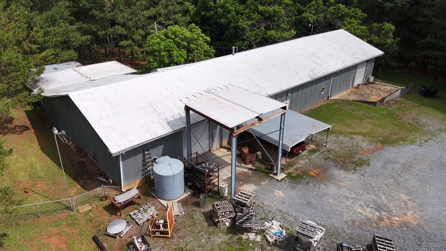
2348 Mariposa Rd, Stanley, NC 28164


Property Detail
2348 Mariposa Rd
02373
PT 1 FISHER PROPERTY
Multipleuses
LINCOLN
R-T
North Carolina
2025
0.48 AC
2025
Lincoln County
030208
Charlotte
5,600 SF
Charlotte-Concord-Gastonia, NC-SC
NEARBY LISTINGS FOR SALE OR LEASE
-
-
View all Stanley listings for sale on LoopNet.com
DEMOGRAPHICS near 2348 Mariposa Rd
1 mile
3 mile
5 mile
2025 Total Population
523
5,286
26,355
2030 Population
580
5,757
28,533
Pop Growth 2025-2030
+ 10.90%
+ 8.91%
+ 8.26%
Average Age
43
44
43
2025 Total Households
205
2,120
10,541
HH Growth 2025-2030
+ 11.22%
+ 8.96%
+ 8.41%
Median Household Inc
$61,304
$75,604
$83,837
Avg Household Size
2.50
2.50
2.50
2025 Avg HH Vehicles
2.00
2.00
2.00
Median Home Value
$354,166
$371,706
$355,067
Median Year Built
1994
1992
1994
Nearby Places
Map Layers
Map Styles
 Street
 Aerial
Layers
 Traffic
 Biking
Places
Listings with unknown addresses are not visible on the map
- Restaurants
- Banks
- Shops
- Fitness
- Groceries
PUBLIC TRANSPORTATION
AIRPORT
Charlotte/Douglas International
Drive
Walk
Distance
Charlotte/Douglas International
39 min
22.2 mi
Concord-Padgett Regional
Drive
Walk
Distance
Concord-Padgett Regional
38 min
27.6 mi
Freight Ports
North Charleston Terminal
Drive
Walk
Distance
North Charleston Terminal
250 min
218.1 mi
SALE & LEASE HISTORY
LISTING DATE
SALE/LEASE

Jun 20, 2025
For Sale
Nearby Properties
Address
Land Use
TOTAL SIZE
Lot Size
Zoning
Address
Land Use
TOTAL SIZE
Lot Size
Zoning
44,424 SF
36.31 AC
ELDD PD-I
Address
Land Use
TOTAL SIZE
Lot Size
Zoning
4,506 SF
38.05 AC
I-G & R-T
Address
Land Use
TOTAL SIZE
Lot Size
Zoning
637.85 AC
R-T & PD-I
Address
Land Use
TOTAL SIZE
Lot Size
Zoning
93,840 SF
32.50 AC
ELDD I-G
Address
Land Use
TOTAL SIZE
Lot Size
Zoning
4,676 SF
15.14 AC
R-SF & R-R
Address
Land Use
TOTAL SIZE
Lot Size
Zoning
142,850 SF
18.06 AC
STOR5
Address
Land Use
TOTAL SIZE
Lot Size
Zoning
15,354 SF
28.48 AC
ELDD I-G
Address
Land Use
TOTAL SIZE
Lot Size
Zoning
57.29 AC
R-T
Address
Land Use
TOTAL SIZE
Lot Size
Zoning
5,366 SF
125.67 AC
R1
Address
Land Use
TOTAL SIZE
Lot Size
Zoning
235.90 AC
I-G CU
Address
Land Use
TOTAL SIZE
Lot Size
Zoning
7,500 SF
3.62 AC
ELDD I-G
Address
Land Use
TOTAL SIZE
Lot Size
Zoning
45,741 SF
2.84 AC
ELDD I-G
Address
Land Use
TOTAL SIZE
Lot Size
Zoning
3,254 SF
85.06 AC
R-T
Address
Land Use
TOTAL SIZE
Lot Size
Zoning
2,052 SF
120.72 AC
R-T
Address
Land Use
TOTAL SIZE
Lot Size
Zoning
2,781 SF
80.69 AC
R1H
Address
Land Use
TOTAL SIZE
Lot Size
Zoning
2,168 SF
3.72 AC
R-T
Address
Land Use
TOTAL SIZE
Lot Size
Zoning
91.75 AC
R-T
Address
Land Use
TOTAL SIZE
Lot Size
Zoning
13,500 SF
6.49 AC
R1
Address
Land Use
TOTAL SIZE
Lot Size
Zoning
1,701 SF
294.17 AC
R1U
Address
Land Use
TOTAL SIZE
Lot Size
Zoning
70.44 AC
R-T
Address
Land Use
TOTAL SIZE
Lot Size
Zoning
1,525 SF
81.94 AC
R-T & R-R
Address
Land Use
TOTAL SIZE
Lot Size
Zoning
864 SF
12.85 AC
R-T
Address
Land Use
TOTAL SIZE
Lot Size
Zoning
5,883 SF
7.41 AC
R-T
Address
Land Use
TOTAL SIZE
Lot Size
Zoning
3,996 SF
11.18 AC
ELDD R-T
Address
Land Use
TOTAL SIZE
Lot Size
Zoning
56.30 AC
R-T
Address
Land Use
TOTAL SIZE
Lot Size
Zoning
59.52 AC
R-T & R-R
Address
Land Use
TOTAL SIZE
Lot Size
Zoning
1,520 SF
39.54 AC
R1H
Address
Land Use
TOTAL SIZE
Lot Size
Zoning
2,052 SF
7.94 AC
Address
Land Use
TOTAL SIZE
Lot Size
Zoning
155.84 AC
R1
Address
Land Use
TOTAL SIZE
Lot Size
Zoning
150.51 AC
The World's #1 Commercial Real Estate Marketplace
Connect with us
© 2026 CoStar Group
The information above has been obtained from sources believed reliable. While we do not doubt its accuracy we have not verified it and make no guarantee, warranty or representation about it. It is your responsibility to independently confirm its accuracy and completeness. Any projections, opinions, assumptions, or estimates used are for example only and do not represent the current or future performance of the property. The value of this transaction to you depends on tax and other factors which should be evaluated by your tax, financial, and legal advisors. You and your advisors should conduct a careful, independent investigation of the property to determine to your satisfaction the suitability of the property for your needs.