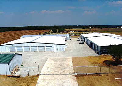
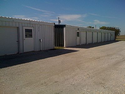
Property Record
2348 Mitchell Rd, Krum, TX 76249


Property Detail
2348 Mitchell Rd
R76750
A1316A VAUGHN, TR 2, 5.0 ACRES
Commercialnec
Denton
B and X Area of moderate flood hazard, usually the area between the limits of the 100-year and 500-year floods.
Texas
2024
5 AC
2025
Outlying Denton County
020206
Dallas/Ft Worth
49,656 SF
Dallas-Fort Worth-Arlington, TX
NEARBY LISTINGS FOR SALE OR LEASE
-
-
View all Krum listings for sale on LoopNet.com
DEMOGRAPHICS near 2348 Mitchell Rd
1 mile
3 mile
5 mile
2025 Total Population
225
9,168
14,954
2030 Population
251
10,344
16,994
Pop Growth 2025-2030
+ 11.56%
+ 12.83%
+ 13.64%
Average Age
43
39
40
2025 Total Households
83
3,078
5,106
HH Growth 2025-2030
+ 12.05%
+ 13.00%
+ 13.89%
Median Household Inc
$105,263
$115,093
$110,718
Avg Household Size
2.70
3.00
2.90
2025 Avg HH Vehicles
3.00
3.00
2.00
Median Home Value
$470,588
$394,763
$399,165
Median Year Built
1988
2003
2003
Nearby Places
Map Layers
Map Styles
 Street
 Aerial
Transit
 Traffic
 Biking
Places
Listings with unknown addresses are not visible on the map
- Restaurants
- Banks
- Shops
- Fitness
- Groceries
PUBLIC TRANSPORTATION
AIRPORT
Dallas-Fort Worth International
Drive
Walk
Distance
Dallas-Fort Worth International
45 min
35.1 mi
Freight Ports
Port of Shreveport
Drive
Walk
Distance
Port of Shreveport
264 min
241.7 mi
Nearby Properties
Address
Land Use
TOTAL SIZE
Lot Size
Zoning
Address
Land Use
TOTAL SIZE
Lot Size
Zoning
167,850 SF
48.14 AC
Address
Land Use
TOTAL SIZE
Lot Size
Zoning
141,468 SF
24.72 AC
Address
Land Use
TOTAL SIZE
Lot Size
Zoning
164,211 SF
11.95 AC
Address
Land Use
TOTAL SIZE
Lot Size
Zoning
126,126 SF
9.45 AC
Address
Land Use
TOTAL SIZE
Lot Size
Zoning
86,702 SF
15.16 AC
Address
Land Use
TOTAL SIZE
Lot Size
Zoning
53,384 SF
19.62 AC
Address
Land Use
TOTAL SIZE
Lot Size
Zoning
81,856 SF
30 AC
Address
Land Use
TOTAL SIZE
Lot Size
Zoning
14,220 SF
14.47 AC
Address
Land Use
TOTAL SIZE
Lot Size
Zoning
13,152 SF
15 AC
Address
Land Use
TOTAL SIZE
Lot Size
Zoning
110.88 AC
Address
Land Use
TOTAL SIZE
Lot Size
Zoning
18,690 SF
9.33 AC
Address
Land Use
TOTAL SIZE
Lot Size
Zoning
21,000 SF
20.42 AC
Address
Land Use
TOTAL SIZE
Lot Size
Zoning
23,082 SF
4 AC
Address
Land Use
TOTAL SIZE
Lot Size
Zoning
336 SF
28.59 AC
Address
Land Use
TOTAL SIZE
Lot Size
Zoning
9,750 SF
5.45 AC
Address
Land Use
TOTAL SIZE
Lot Size
Zoning
36,028 SF
19.07 AC
Address
Land Use
TOTAL SIZE
Lot Size
Zoning
32,800 SF
5.93 AC
Address
Land Use
TOTAL SIZE
Lot Size
Zoning
6.95 AC
Address
Land Use
TOTAL SIZE
Lot Size
Zoning
13,120 SF
3.64 AC
Address
Land Use
TOTAL SIZE
Lot Size
Zoning
48,400 SF
10.30 AC
Address
Land Use
TOTAL SIZE
Lot Size
Zoning
55,150 SF
6.47 AC
Address
Land Use
TOTAL SIZE
Lot Size
Zoning
65,782 SF
0.20 AC
Address
Land Use
TOTAL SIZE
Lot Size
Zoning
7,356 SF
1.50 AC
Address
Land Use
TOTAL SIZE
Lot Size
Zoning
6,368 SF
155.59 AC
Address
Land Use
TOTAL SIZE
Lot Size
Zoning
20,068 SF
0.17 AC
Address
Land Use
TOTAL SIZE
Lot Size
Zoning
19,064 SF
10 AC
Address
Land Use
TOTAL SIZE
Lot Size
Zoning
30 AC
Address
Land Use
TOTAL SIZE
Lot Size
Zoning
15,760 SF
7.64 AC
The World's #1 Commercial Real Estate Marketplace
Connect with us
© 2026 CoStar Group
The information above has been obtained from sources believed reliable. While we do not doubt its accuracy we have not verified it and make no guarantee, warranty or representation about it. It is your responsibility to independently confirm its accuracy and completeness. Any projections, opinions, assumptions, or estimates used are for example only and do not represent the current or future performance of the property. The value of this transaction to you depends on tax and other factors which should be evaluated by your tax, financial, and legal advisors. You and your advisors should conduct a careful, independent investigation of the property to determine to your satisfaction the suitability of the property for your needs.