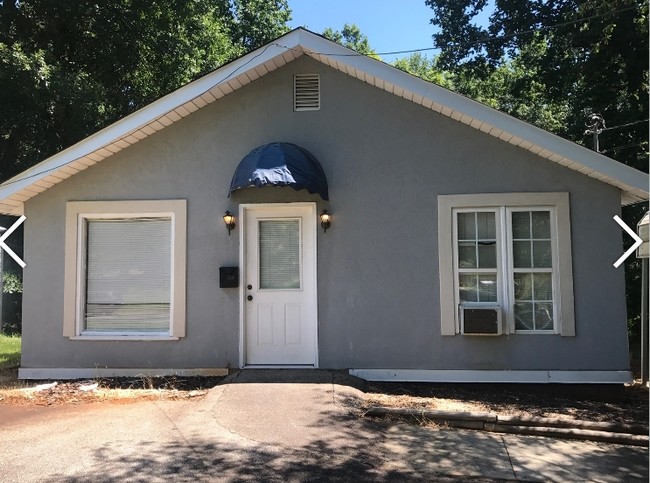
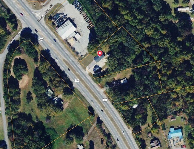
Property Record
2349 Athens Hwy, Gainesville, GA 30507

NEARBY LISTINGS FOR SALE OR LEASE
Property Detail
2349 Athens Hwy
15-0022C-000-15A
ATHENS HIGHWAY
Storebuilding
Hall
X
Georgia
13139C0195H
1.41 AC
2025
Gainesville/Hall County
2025
Atlanta
000704
Gainesville, GA
1,312 SF
DEMOGRAPHICS near 2349 Athens Hwy
1 Mile
3 Mile
5 Mile
2024 Total Population
1,765
18,503
60,984
2029 Population
1,955
20,463
67,188
Pop Growth 2024-2029
+ 10.76%
+ 10.59%
+ 10.17%
Average Age
33
34
34
2024 Total Households
487
5,290
18,891
HH Growth 2024-2029
+ 10.68%
+ 10.57%
+ 10.12%
Median Household Inc
$56,938
$39,605
$52,066
Avg Household Size
3.70
3.30
3.00
2024 Avg HH Vehicles
3.00
2.00
2.00
Median Home Value
$176,630
$158,361
$201,644
Median Year Built
2001
1993
1988
Nearby Places
Map Layers
Map Styles
 Street
 Aerial
- Restaurants
- Banks
- Shops
- Fitness
- Groceries
PUBLIC TRANSPORTATION
COMMUTER RAIL
Gainesville Amtrak Station (Crescent - Amtrak)
DRIVE
WALK
Distance
Gainesville Amtrak Station (Crescent - Amtrak)
4 min
3.6 mi
Freight Ports
Georgia Ports - Savannah
DRIVE
WALK
Distance
Georgia Ports - Savannah
311 min
247.5 mi
SALE & LEASE HISTORY
LISTING DATE
SALE/LEASE

Sep 19, 2018
For Sale
Nov 25, 2024
For Sale
Jun 15, 2018
For Sale
Aug 17, 2020
For Sale
Aug 02, 2017
For Sale
Nearby Properties
Address
Land Use
TOTAL SIZE
Lot Size
Zoning
Address
Land Use
TOTAL SIZE
Lot Size
Zoning
578,645 SF
110.18 AC
PUD
Address
Land Use
TOTAL SIZE
Lot Size
Zoning
334,800 SF
56.96 AC
PUD
Address
Land Use
TOTAL SIZE
Lot Size
Zoning
273,931 SF
34.09 AC
I-1
Address
Land Use
TOTAL SIZE
Lot Size
Zoning
258,201 SF
38.83 AC
I-1
Address
Land Use
TOTAL SIZE
Lot Size
Zoning
3,284 SF
28.53 AC
PUD
Address
Land Use
TOTAL SIZE
Lot Size
Zoning
77,333 SF
11.74 AC
PUD
Address
Land Use
TOTAL SIZE
Lot Size
Zoning
54,751 SF
33.38 AC
AR-1
Address
Land Use
TOTAL SIZE
Lot Size
Zoning
469,180 SF
25.56 AC
H-I
Address
Land Use
TOTAL SIZE
Lot Size
Zoning
88,042 SF
280.24 AC
PID
Address
Land Use
TOTAL SIZE
Lot Size
Zoning
6.23 AC
R-II
Address
Land Use
TOTAL SIZE
Lot Size
Zoning
97,660 SF
7.17 AC
R-II
Address
Land Use
TOTAL SIZE
Lot Size
Zoning
194,850 SF
9.28 AC
L-I
Address
Land Use
TOTAL SIZE
Lot Size
Zoning
91,728 SF
15 AC
L-I
Address
Land Use
TOTAL SIZE
Lot Size
Zoning
286,880 SF
18.38 AC
H-I
Address
Land Use
TOTAL SIZE
Lot Size
Zoning
145,064 SF
7.47 AC
I-1
Address
Land Use
TOTAL SIZE
Lot Size
Zoning
82,174 SF
8.39 AC
R-II
Address
Land Use
TOTAL SIZE
Lot Size
Zoning
162,813 SF
11.24 AC
H-I
Address
Land Use
TOTAL SIZE
Lot Size
Zoning
20,250 SF
23.43 AC
H-I
Address
Land Use
TOTAL SIZE
Lot Size
Zoning
43,170 SF
23.06 AC
PUD
Address
Land Use
TOTAL SIZE
Lot Size
Zoning
108,239 SF
16.54 AC
H-I
Address
Land Use
TOTAL SIZE
Lot Size
Zoning
90,000 SF
10.66 AC
H-I
Address
Land Use
TOTAL SIZE
Lot Size
Zoning
135,522 SF
8.57 AC
L-I
Address
Land Use
TOTAL SIZE
Lot Size
Zoning
192,266 SF
12.38 AC
H-I
Address
Land Use
TOTAL SIZE
Lot Size
Zoning
155,360 SF
3.76 AC
H-I
Address
Land Use
TOTAL SIZE
Lot Size
Zoning
14,980 SF
136.15 AC
AR-1
Address
Land Use
TOTAL SIZE
Lot Size
Zoning
190,756 SF
9.32 AC
H-I
Address
Land Use
TOTAL SIZE
Lot Size
Zoning
522,274 SF
26.70 AC
I-2
Address
Land Use
TOTAL SIZE
Lot Size
Zoning
9,504 SF
3.62 AC
R-II
Address
Land Use
TOTAL SIZE
Lot Size
Zoning
76,114 SF
20.42 AC
R-II
Address
Land Use
TOTAL SIZE
Lot Size
Zoning
175,512 SF
I-1
The World's #1 Commercial Real Estate Marketplace
Connect with us
© 2025 CoStar Group
The information above has been obtained from sources believed reliable. While we do not doubt its accuracy we have not verified it and make no guarantee, warranty or representation about it. It is your responsibility to independently confirm its accuracy and completeness. Any projections, opinions, assumptions, or estimates used are for example only and do not represent the current or future performance of the property. The value of this transaction to you depends on tax and other factors which should be evaluated by your tax, financial, and legal advisors. You and your advisors should conduct a careful, independent investigation of the property to determine to your satisfaction the suitability of the property for your needs.