Property Record
235 Broadpointe Dr, Mills River, NC 28759
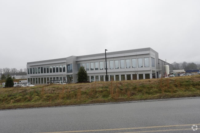


Property Detail
235 Broadpointe Dr
9642271010
D4 BROADPOINTE CTR
Industrialgeneral
HENDERSON
10001357~M
North Carolina
C and X Area of minimal flood hazard, usually depicted on FIRMs as above the 500-year flood level.
1010
2025
9.95 AC
2025
Henderson County
930701
Asheville
82,202 SF
Asheville, NC
NEARBY LISTINGS FOR SALE OR LEASE
DEMOGRAPHICS near 235 Broadpointe Dr
1 mile
3 mile
5 mile
2025 Total Population
702
17,673
51,778
2030 Population
736
18,206
53,328
Pop Growth 2025-2030
+ 4.84%
+ 3.02%
+ 2.99%
Average Age
43
42
42
2025 Total Households
272
7,203
21,609
HH Growth 2025-2030
+ 5.15%
+ 3.08%
+ 2.95%
Median Household Inc
$87,053
$80,110
$81,337
Avg Household Size
2.60
2.40
2.40
2025 Avg HH Vehicles
2.00
2.00
2.00
Median Home Value
$355,797
$383,333
$408,783
Median Year Built
2001
1997
1997
Nearby Places
Map Layers
Map Styles
 Street
 Aerial
Transit
 Traffic
 Biking
Places
Listings with unknown addresses are not visible on the map
- Restaurants
- Banks
- Shops
- Fitness
- Groceries
PUBLIC TRANSPORTATION
AIRPORT
Asheville Regional
Drive
Walk
Distance
Asheville Regional
4 min
2.2 mi
Nearby Properties
Address
Land Use
TOTAL SIZE
Lot Size
Zoning
Address
Land Use
TOTAL SIZE
Lot Size
Zoning
107,063 SF
567.34 AC
AI
Address
Land Use
TOTAL SIZE
Lot Size
Zoning
281,505 SF
38.35 AC
10000070~M
Address
Land Use
TOTAL SIZE
Lot Size
Zoning
85,103 SF
11.69 AC
RES EXP
Address
Land Use
TOTAL SIZE
Lot Size
Zoning
107,408 SF
21.92 AC
R-3
Address
Land Use
TOTAL SIZE
Lot Size
Zoning
198,705 SF
32.46 AC
HB
Address
Land Use
TOTAL SIZE
Lot Size
Zoning
481,731 SF
86.32 AC
1009658~I
Address
Land Use
TOTAL SIZE
Lot Size
Zoning
21.70 AC
10005690~M
Address
Land Use
TOTAL SIZE
Lot Size
Zoning
3,466 SF
11.32 AC
10000832~M
Address
Land Use
TOTAL SIZE
Lot Size
Zoning
4,839 SF
9.46 AC
10002512~C
Address
Land Use
TOTAL SIZE
Lot Size
Zoning
92,772 SF
12.30 AC
R-2
Address
Land Use
TOTAL SIZE
Lot Size
Zoning
43,882 SF
9.71 AC
1016337~C1
Address
Land Use
TOTAL SIZE
Lot Size
Zoning
365,659 SF
38.28 AC
9958527~M-
Address
Land Use
TOTAL SIZE
Lot Size
Zoning
86,393 SF
15.44 AC
PS
Address
Land Use
TOTAL SIZE
Lot Size
Zoning
14,704 SF
3.31 AC
10007972~M
Address
Land Use
TOTAL SIZE
Lot Size
Zoning
39.98 AC
10007822~M
Address
Land Use
TOTAL SIZE
Lot Size
Zoning
107,698 SF
25.53 AC
PS
Address
Land Use
TOTAL SIZE
Lot Size
Zoning
208,715 SF
33.50 AC
CI
Address
Land Use
TOTAL SIZE
Lot Size
Zoning
76,255 SF
10.55 AC
EMP
Address
Land Use
TOTAL SIZE
Lot Size
Zoning
3,000 SF
48.13 AC
10010496~M
Address
Land Use
TOTAL SIZE
Lot Size
Zoning
13,525 SF
1.84 AC
LODG EXP
Address
Land Use
TOTAL SIZE
Lot Size
Zoning
15,493 SF
2.01 AC
EMP
Address
Land Use
TOTAL SIZE
Lot Size
Zoning
28,183 SF
5.88 AC
10010086~C
Address
Land Use
TOTAL SIZE
Lot Size
Zoning
44,384 SF
9.54 AC
R-3
Address
Land Use
TOTAL SIZE
Lot Size
Zoning
112,100 SF
14.22 AC
9975597~MR
Address
Land Use
TOTAL SIZE
Lot Size
Zoning
14,024 SF
2 AC
HB
Address
Land Use
TOTAL SIZE
Lot Size
Zoning
83,741 SF
24.39 AC
9959040~MR
Address
Land Use
TOTAL SIZE
Lot Size
Zoning
178,825 SF
25.05 AC
1016341~MR
Address
Land Use
TOTAL SIZE
Lot Size
Zoning
237,185 SF
17.57 AC
9962196~MR
Address
Land Use
TOTAL SIZE
Lot Size
Zoning
51,090 SF
5.18 AC
1007612~C-
Address
Land Use
TOTAL SIZE
Lot Size
Zoning
345,310 SF
16.60 AC
R-2
The World's #1 Commercial Real Estate Marketplace
Connect with us
© 2026 CoStar Group
The information above has been obtained from sources believed reliable. While we do not doubt its accuracy we have not verified it and make no guarantee, warranty or representation about it. It is your responsibility to independently confirm its accuracy and completeness. Any projections, opinions, assumptions, or estimates used are for example only and do not represent the current or future performance of the property. The value of this transaction to you depends on tax and other factors which should be evaluated by your tax, financial, and legal advisors. You and your advisors should conduct a careful, independent investigation of the property to determine to your satisfaction the suitability of the property for your needs.