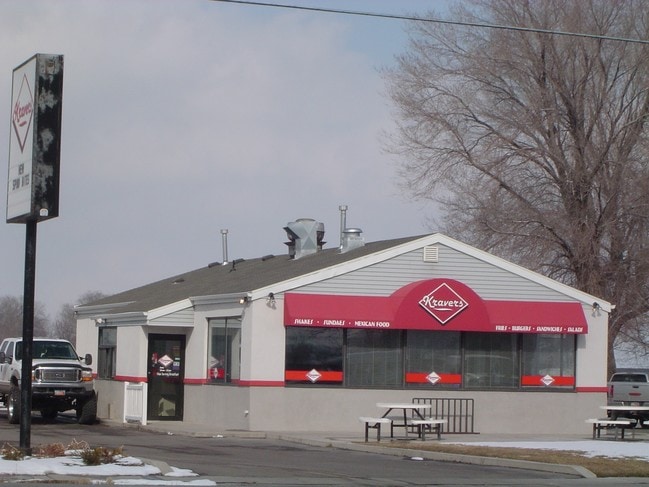
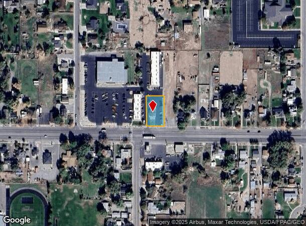
Property Record
235 E Main St, Grantsville, UT 84029
NEARBY LISTINGS FOR SALE OR LEASE
Property Detail
235 E Main St
01-048-0-0044
BEG 2.44 CHS E FR SW COR OF NE 1/4 OF SEC 31, T2S, R5W, SLB&M, TH E 12 FT M/L TO THE TRUE POB, TH E 106 FT, TH N 180 FT, TH W
Commercialnec
Tooele
D
Utah
49045C1605C
0.44 AC
2025
Tooele County
2025
Salt Lake City
130800
Salt Lake City-Murray, UT
1,916 SF
DEMOGRAPHICS near 235 E Main St
1 Mile
3 Mile
5 Mile
2024 Total Population
5,154
16,139
16,512
2029 Population
6,478
20,333
20,805
Pop Growth 2024-2029
+ 25.69%
+ 25.99%
+ 26.00%
Average Age
36
34
34
2024 Total Households
1,614
4,749
4,855
HH Growth 2024-2029
+ 26.21%
+ 26.41%
+ 26.43%
Median Household Inc
$79,948
$90,531
$90,802
Avg Household Size
3.20
3.40
3.40
2024 Avg HH Vehicles
3.00
3.00
3.00
Median Home Value
$430,346
$409,247
$407,375
Median Year Built
1997
2005
2005
Nearby Places
Map Layers
Map Styles
 Street
 Aerial
- Restaurants
- Banks
- Shops
- Fitness
- Groceries
PUBLIC TRANSPORTATION
AIRPORT
Salt Lake City International
DRIVE
WALK
Distance
Salt Lake City International
40 min
31.8 mi
Nearby Properties
Address
Land Use
TOTAL SIZE
Lot Size
Zoning
Address
Land Use
TOTAL SIZE
Lot Size
Zoning
47,247 SF
4.21 AC
Address
Land Use
TOTAL SIZE
Lot Size
Zoning
109.16 AC
Address
Land Use
TOTAL SIZE
Lot Size
Zoning
Address
Land Use
TOTAL SIZE
Lot Size
Zoning
4,369 SF
1.59 AC
Address
Land Use
TOTAL SIZE
Lot Size
Zoning
1,327 SF
26.39 AC
Address
Land Use
TOTAL SIZE
Lot Size
Zoning
37,500 SF
7.38 AC
Address
Land Use
TOTAL SIZE
Lot Size
Zoning
1,125 SF
3.37 AC
Address
Land Use
TOTAL SIZE
Lot Size
Zoning
10,639 SF
2.15 AC
Address
Land Use
TOTAL SIZE
Lot Size
Zoning
1,996 SF
3.72 AC
Address
Land Use
TOTAL SIZE
Lot Size
Zoning
10,843 SF
35.78 AC
Address
Land Use
TOTAL SIZE
Lot Size
Zoning
9,394 SF
2.65 AC
Address
Land Use
TOTAL SIZE
Lot Size
Zoning
8,434 SF
2.49 AC
Address
Land Use
TOTAL SIZE
Lot Size
Zoning
7,080 SF
5.25 AC
Address
Land Use
TOTAL SIZE
Lot Size
Zoning
17,086 SF
1.05 AC
Address
Land Use
TOTAL SIZE
Lot Size
Zoning
6,348 SF
10.11 AC
Address
Land Use
TOTAL SIZE
Lot Size
Zoning
4,189 SF
1.07 AC
Address
Land Use
TOTAL SIZE
Lot Size
Zoning
7,000 SF
2.04 AC
Address
Land Use
TOTAL SIZE
Lot Size
Zoning
9,905 SF
1.48 AC
Address
Land Use
TOTAL SIZE
Lot Size
Zoning
5,275 SF
21.09 AC
Address
Land Use
TOTAL SIZE
Lot Size
Zoning
6,700 SF
1.13 AC
Address
Land Use
TOTAL SIZE
Lot Size
Zoning
39.49 AC
Address
Land Use
TOTAL SIZE
Lot Size
Zoning
4,692 SF
14.16 AC
Address
Land Use
TOTAL SIZE
Lot Size
Zoning
5,045 SF
2.78 AC
Address
Land Use
TOTAL SIZE
Lot Size
Zoning
7,171 SF
0.72 AC
The World's #1 Commercial Real Estate Marketplace
Connect with us
© 2026 CoStar Group
The information above has been obtained from sources believed reliable. While we do not doubt its accuracy we have not verified it and make no guarantee, warranty or representation about it. It is your responsibility to independently confirm its accuracy and completeness. Any projections, opinions, assumptions, or estimates used are for example only and do not represent the current or future performance of the property. The value of this transaction to you depends on tax and other factors which should be evaluated by your tax, financial, and legal advisors. You and your advisors should conduct a careful, independent investigation of the property to determine to your satisfaction the suitability of the property for your needs.