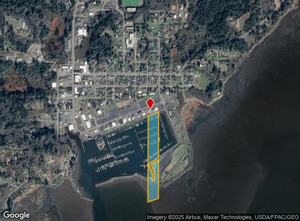
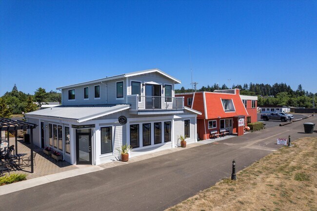
Property Record
235 Howerton Way Se, Ilwaco, WA 98624

NEARBY LISTINGS FOR SALE OR LEASE
Property Detail
235 Howerton Way Se
Restaurantbuilding
Port Of Ilwaco
X
PORT OF ILWACO BLK 4 10&11; BLDG ON LEASED LAND #81714
53049C0300D
Pacific
2024
Washington
2025
Washington State Area
950502
Other Market Areas
2,392 SF
81714050000
DEMOGRAPHICS near 235 Howerton Way Se
1 Mile
3 Mile
5 Mile
2024 Total Population
633
2,804
5,465
2029 Population
668
3,064
6,084
Pop Growth 2024-2029
+ 5.53%
+ 9.27%
+ 11.33%
Average Age
46
48
47
2024 Total Households
284
1,341
2,560
HH Growth 2024-2029
+ 5.28%
+ 8.80%
+ 10.90%
Median Household Inc
$67,222
$53,010
$48,541
Avg Household Size
2.20
2.10
2.10
2024 Avg HH Vehicles
2.00
2.00
2.00
Median Home Value
$343,939
$310,278
$294,950
Median Year Built
1970
1978
1976
Nearby Places
Map Layers
Map Styles
 Street
 Aerial
- Restaurants
- Banks
- Shops
- Fitness
- Groceries
SALE & LEASE HISTORY
LISTING DATE
SALE/LEASE

Sep 23, 2016
For Sale
Jul 24, 2023
For Sale
Nearby Properties
Address
Land Use
TOTAL SIZE
Lot Size
Zoning
Address
Land Use
TOTAL SIZE
Lot Size
Zoning
35,664 SF
3.68 AC
UGA
Address
Land Use
TOTAL SIZE
Lot Size
Zoning
18,904 SF
0.31 AC
UGA
Address
Land Use
TOTAL SIZE
Lot Size
Zoning
1,200 SF
0.46 AC
CC
Address
Land Use
TOTAL SIZE
Lot Size
Zoning
10,255 SF
2.90 AC
UGA
Address
Land Use
TOTAL SIZE
Lot Size
Zoning
272 AC
CD
Address
Land Use
TOTAL SIZE
Lot Size
Zoning
17,664 SF
0.92 AC
CC
Address
Land Use
TOTAL SIZE
Lot Size
Zoning
3,096 SF
14.41 AC
R3
Address
Land Use
TOTAL SIZE
Lot Size
Zoning
2,880 SF
0.46 AC
CC
Address
Land Use
TOTAL SIZE
Lot Size
Zoning
5,159 SF
0.23 AC
CC
Address
Land Use
TOTAL SIZE
Lot Size
Zoning
13,137 SF
0.85 AC
UGA
Address
Land Use
TOTAL SIZE
Lot Size
Zoning
9,040 SF
10 AC
IND
Address
Land Use
TOTAL SIZE
Lot Size
Zoning
8,880 SF
0.40 AC
UGA
Address
Land Use
TOTAL SIZE
Lot Size
Zoning
7,800 SF
0.52 AC
Address
Land Use
TOTAL SIZE
Lot Size
Zoning
10,368 SF
0.35 AC
CC
Address
Land Use
TOTAL SIZE
Lot Size
Zoning
5,631 SF
0.45 AC
Address
Land Use
TOTAL SIZE
Lot Size
Zoning
3,745 SF
0.86 AC
UGA
Address
Land Use
TOTAL SIZE
Lot Size
Zoning
11,376 SF
0.43 AC
UGA
Address
Land Use
TOTAL SIZE
Lot Size
Zoning
24,926 SF
0.57 AC
UGA
Address
Land Use
TOTAL SIZE
Lot Size
Zoning
9,864 SF
2.97 AC
UGA
Address
Land Use
TOTAL SIZE
Lot Size
Zoning
5,110 SF
0.30 AC
UGA
Address
Land Use
TOTAL SIZE
Lot Size
Zoning
7,747 SF
1.03 AC
R2
Address
Land Use
TOTAL SIZE
Lot Size
Zoning
7,190 SF
1.28 AC
UGA
Address
Land Use
TOTAL SIZE
Lot Size
Zoning
97.70 AC
UGA
Address
Land Use
TOTAL SIZE
Lot Size
Zoning
9,728 SF
Address
Land Use
TOTAL SIZE
Lot Size
Zoning
5,756 SF
0.28 AC
UGA
Address
Land Use
TOTAL SIZE
Lot Size
Zoning
6,176 SF
0.44 AC
UGA
Address
Land Use
TOTAL SIZE
Lot Size
Zoning
10,912 SF
0.42 AC
UGA
Address
Land Use
TOTAL SIZE
Lot Size
Zoning
10,720 SF
0.20 AC
UGA
Address
Land Use
TOTAL SIZE
Lot Size
Zoning
2,704 SF
0.72 AC
UGA
Address
Land Use
TOTAL SIZE
Lot Size
Zoning
5,638 SF
2.71 AC
R3
The World's #1 Commercial Real Estate Marketplace
Connect with us
© 2025 CoStar Group
The information above has been obtained from sources believed reliable. While we do not doubt its accuracy we have not verified it and make no guarantee, warranty or representation about it. It is your responsibility to independently confirm its accuracy and completeness. Any projections, opinions, assumptions, or estimates used are for example only and do not represent the current or future performance of the property. The value of this transaction to you depends on tax and other factors which should be evaluated by your tax, financial, and legal advisors. You and your advisors should conduct a careful, independent investigation of the property to determine to your satisfaction the suitability of the property for your needs.