Property Record
235 Ironworks Ave, Mishawaka, IN 46544

Current Lease Availabilities
NEARBY LISTINGS FOR SALE OR LEASE
Property Detail
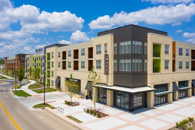
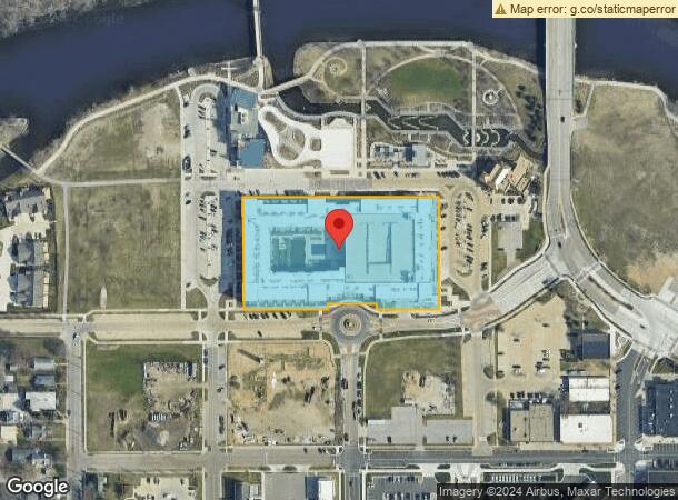
235 Ironworks Ave
South Bend-Mishawaka, IN-MI
The Mill At Ironworks 18/19
71-09-16-202-003.000-023
LOT 1 THE MILL AT IRONWORKS 18/19 NP #1735080 3758 12/21/17
Apartment
St Joseph
AE
Indiana
18141C0216D
1
2023
3.50 AC
2024
Mishawaka
010202
South Bend/Mishawaka
397,501 SF
DEMOGRAPHICS near 235 Ironworks Ave
1 Mile
3 Mile
5 Mile
2024 Total Population
15,707
79,144
159,533
2029 Population
15,727
79,000
159,733
Pop Growth 2024-2029
+ 0.13%
(0.18%)
+ 0.13%
Average Age
38
39
38
2024 Total Households
6,802
34,363
64,385
HH Growth 2024-2029
+ 0.32%
(0.17%)
+ 0.13%
Median Household Inc
$43,258
$52,140
$54,821
Avg Household Size
2.20
2.20
2.20
2024 Avg HH Vehicles
2.00
2.00
2.00
Median Home Value
$106,273
$135,278
$148,092
Median Year Built
1951
1961
1965
Nearby Places
Map Layers
Map Styles
 Street
 Aerial
- Restaurants
- Banks
- Shops
- Fitness
- Groceries
PUBLIC TRANSPORTATION
COMMUTER RAIL
South Bend Amtrak Station (Capitol Limited - Amtrak, Lake Shore Limited - Amtrak)
DRIVE
WALK
Distance
South Bend Amtrak Station (Capitol Limited - Amtrak, Lake Shore Limited - Amtrak)
11 min
6.5 mi
South Bend Airport Station (South Shore Line - Northern Indiana Commuter Transportation District (South Shore Line))
DRIVE
WALK
Distance
South Bend Airport Station (South Shore Line - Northern Indiana Commuter Transportation District (South Shore Line))
15 min
8.3 mi
AIRPORT
South Bend International
DRIVE
WALK
Distance
South Bend International
24 min
10.5 mi
Freight Ports
Port Milwaukee
DRIVE
WALK
Distance
Port Milwaukee
226 min
179.6 mi
Nearby Properties
Address
Land Use
TOTAL SIZE
Lot Size
Zoning
Address
Land Use
TOTAL SIZE
Lot Size
Zoning
560,184 SF
0.01 AC
Address
Land Use
TOTAL SIZE
Lot Size
Zoning
630,870 SF
0.01 AC
Address
Land Use
TOTAL SIZE
Lot Size
Zoning
155,459 SF
0.01 AC
Address
Land Use
TOTAL SIZE
Lot Size
Zoning
770,407 SF
0.01 AC
Address
Land Use
TOTAL SIZE
Lot Size
Zoning
338,816 SF
33.65 AC
Address
Land Use
TOTAL SIZE
Lot Size
Zoning
283,481 SF
51.29 AC
Address
Land Use
TOTAL SIZE
Lot Size
Zoning
327,618 SF
39.65 AC
Address
Land Use
TOTAL SIZE
Lot Size
Zoning
65,986 SF
174 SF
Address
Land Use
TOTAL SIZE
Lot Size
Zoning
107,258 SF
1.61 AC
Address
Land Use
TOTAL SIZE
Lot Size
Zoning
124,260 SF
44 SF
Address
Land Use
TOTAL SIZE
Lot Size
Zoning
112,424 SF
5 AC
Address
Land Use
TOTAL SIZE
Lot Size
Zoning
360,056 SF
19.59 AC
Address
Land Use
TOTAL SIZE
Lot Size
Zoning
205,586 SF
4.18 AC
Address
Land Use
TOTAL SIZE
Lot Size
Zoning
218,000 SF
24.57 AC
Address
Land Use
TOTAL SIZE
Lot Size
Zoning
353.40 AC
Address
Land Use
TOTAL SIZE
Lot Size
Zoning
216,257 SF
37.13 AC
Address
Land Use
TOTAL SIZE
Lot Size
Zoning
122,419 SF
44 SF
Address
Land Use
TOTAL SIZE
Lot Size
Zoning
172,995 SF
14.44 AC
Address
Land Use
TOTAL SIZE
Lot Size
Zoning
54,226 SF
44 SF
Address
Land Use
TOTAL SIZE
Lot Size
Zoning
100,191 SF
11.72 AC
Address
Land Use
TOTAL SIZE
Lot Size
Zoning
123,382 SF
18.94 AC
Address
Land Use
TOTAL SIZE
Lot Size
Zoning
153,130 SF
44 SF
Address
Land Use
TOTAL SIZE
Lot Size
Zoning
386,403 SF
23.89 AC
Address
Land Use
TOTAL SIZE
Lot Size
Zoning
211,770 SF
174 SF
Address
Land Use
TOTAL SIZE
Lot Size
Zoning
177,518 SF
35.64 AC
Address
Land Use
TOTAL SIZE
Lot Size
Zoning
61,245 SF
3.54 AC
Address
Land Use
TOTAL SIZE
Lot Size
Zoning
79,911 SF
18.98 AC
Address
Land Use
TOTAL SIZE
Lot Size
Zoning
109,152 SF
87 SF
Address
Land Use
TOTAL SIZE
Lot Size
Zoning
105,917 SF
44 SF
The World's #1 Commercial Real Estate Marketplace
Connect with us
© 2026 CoStar Group
The information above has been obtained from sources believed reliable. While we do not doubt its accuracy we have not verified it and make no guarantee, warranty or representation about it. It is your responsibility to independently confirm its accuracy and completeness. Any projections, opinions, assumptions, or estimates used are for example only and do not represent the current or future performance of the property. The value of this transaction to you depends on tax and other factors which should be evaluated by your tax, financial, and legal advisors. You and your advisors should conduct a careful, independent investigation of the property to determine to your satisfaction the suitability of the property for your needs.