Property Record
235 Maple St, Metamora, OH 43540
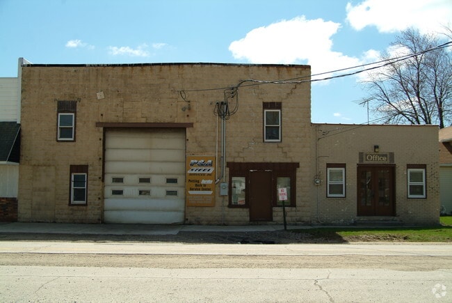

This Property Is For Sale
Property Detail
235 Maple St
02-002480-00.000
CULVERS ADDITION LOT 38 PT
Commercialnec
FULTON
B1
Ohio
B and X Area of moderate flood hazard, usually the area between the limits of the 100-year and 500-year floods.
38
2024
0.20 AC
2024
Fulton County
040100
Toledo
700 SF
Toledo, OH
NEARBY LISTINGS FOR SALE OR LEASE
-
-
View all Metamora listings for sale on LoopNet.com
DEMOGRAPHICS near 235 Maple St
1 mile
3 mile
5 mile
2025 Total Population
672
1,796
3,451
2030 Population
683
1,792
3,409
Pop Growth 2025-2030
+ 1.64%
(0.22%)
(1.22%)
Average Age
38
41
42
2025 Total Households
247
671
1,312
HH Growth 2025-2030
+ 1.62%
(0.30%)
(1.37%)
Median Household Inc
$94,551
$94,473
$92,912
Avg Household Size
2.70
2.70
2.60
2025 Avg HH Vehicles
2.00
2.00
2.00
Median Home Value
$197,673
$220,526
$229,268
Median Year Built
1951
1950
1952
Nearby Places
Map Layers
Map Styles
 Street
 Aerial
Transit
 Traffic
 Biking
Places
Listings with unknown addresses are not visible on the map
- Restaurants
- Banks
- Shops
- Fitness
- Groceries
PUBLIC TRANSPORTATION
AIRPORT
Eugene F Kranz Toledo Express
Drive
Walk
Distance
Eugene F Kranz Toledo Express
31 min
16.3 mi
Freight Ports
Port of Toledo
Drive
Walk
Distance
Port of Toledo
47 min
29.3 mi
Nearby Properties
Address
Land Use
TOTAL SIZE
Lot Size
Zoning
Address
Land Use
TOTAL SIZE
Lot Size
Zoning
6,036 SF
14.26 AC
Address
Land Use
TOTAL SIZE
Lot Size
Zoning
76,650 SF
10.04 AC
M2
Address
Land Use
TOTAL SIZE
Lot Size
Zoning
Address
Land Use
TOTAL SIZE
Lot Size
Zoning
145.81 AC
Address
Land Use
TOTAL SIZE
Lot Size
Zoning
332.12 AC
Address
Land Use
TOTAL SIZE
Lot Size
Zoning
57.90 AC
Address
Land Use
TOTAL SIZE
Lot Size
Zoning
72,000 SF
20.96 AC
Address
Land Use
TOTAL SIZE
Lot Size
Zoning
116.60 AC
Address
Land Use
TOTAL SIZE
Lot Size
Zoning
Address
Land Use
TOTAL SIZE
Lot Size
Zoning
101.87 AC
Address
Land Use
TOTAL SIZE
Lot Size
Zoning
83.65 AC
Address
Land Use
TOTAL SIZE
Lot Size
Zoning
Address
Land Use
TOTAL SIZE
Lot Size
Zoning
Address
Land Use
TOTAL SIZE
Lot Size
Zoning
97.77 AC
Address
Land Use
TOTAL SIZE
Lot Size
Zoning
277.71 AC
Address
Land Use
TOTAL SIZE
Lot Size
Zoning
97.47 AC
Address
Land Use
TOTAL SIZE
Lot Size
Zoning
232.72 AC
Address
Land Use
TOTAL SIZE
Lot Size
Zoning
Address
Land Use
TOTAL SIZE
Lot Size
Zoning
86.42 AC
Address
Land Use
TOTAL SIZE
Lot Size
Zoning
2,245 SF
135.21 AC
Address
Land Use
TOTAL SIZE
Lot Size
Zoning
Address
Land Use
TOTAL SIZE
Lot Size
Zoning
235.35 AC
Address
Land Use
TOTAL SIZE
Lot Size
Zoning
2,312 SF
153.32 AC
Address
Land Use
TOTAL SIZE
Lot Size
Zoning
3,058 SF
159 AC
Address
Land Use
TOTAL SIZE
Lot Size
Zoning
85.71 AC
Address
Land Use
TOTAL SIZE
Lot Size
Zoning
Address
Land Use
TOTAL SIZE
Lot Size
Zoning
9,329 SF
0.44 AC
S1
Address
Land Use
TOTAL SIZE
Lot Size
Zoning
8,236 SF
7.67 AC
C3
Address
Land Use
TOTAL SIZE
Lot Size
Zoning
87.70 AC
Address
Land Use
TOTAL SIZE
Lot Size
Zoning
The World's #1 Commercial Real Estate Marketplace
Connect with us
© 2026 CoStar Group
The information above has been obtained from sources believed reliable. While we do not doubt its accuracy we have not verified it and make no guarantee, warranty or representation about it. It is your responsibility to independently confirm its accuracy and completeness. Any projections, opinions, assumptions, or estimates used are for example only and do not represent the current or future performance of the property. The value of this transaction to you depends on tax and other factors which should be evaluated by your tax, financial, and legal advisors. You and your advisors should conduct a careful, independent investigation of the property to determine to your satisfaction the suitability of the property for your needs.