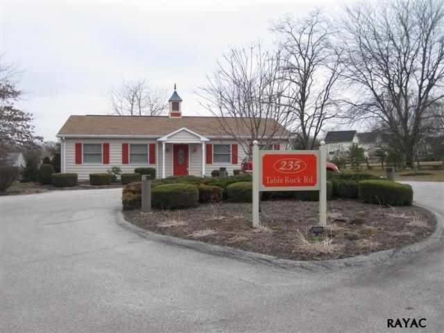
Property Record
235 Table Rock Rd, Gettysburg, PA 17325


NEARBY LISTINGS FOR SALE OR LEASE
Property Detail
235 Table Rock Rd
09-F12-0063B-000
Adams
Commercialnec
Pennsylvania
X
p-0001
42001C0251E
0.88 AC
2025
Adams County
2025
Philadelphia
031401
Gettysburg, PA
DEMOGRAPHICS near 235 Table Rock Rd
1 mile
3 mile
5 mile
2024 Total Population
2,118
16,597
24,387
2029 Population
2,170
16,907
24,878
Pop Growth 2024-2029
+ 2.46%
+ 1.87%
+ 2.01%
Average Age
47
41
43
2024 Total Households
803
5,771
8,777
HH Growth 2024-2029
+ 1.99%
+ 2.06%
+ 2.12%
Median Household Inc
$90,513
$70,417
$72,137
Avg Household Size
2.30
2.20
2.30
2024 Avg HH Vehicles
2.00
2.00
2.00
Median Home Value
$293,004
$276,537
$266,938
Median Year Built
1984
1970
1972
Nearby Places
Map Layers
Map Styles
 Street
 Aerial
Transit
 Traffic
 Biking
Places
Listings with unknown addresses are not visible on the map
- Restaurants
- Banks
- Shops
- Fitness
- Groceries
PUBLIC TRANSPORTATION
AIRPORT
Hagerstown Regional/Richard A Henson Field
Drive
Walk
Distance
Hagerstown Regional/Richard A Henson Field
62 min
34.8 mi
Harrisburg International
Drive
Walk
Distance
Harrisburg International
65 min
45.5 mi
Freight Ports
Port of Baltimore
Drive
Walk
Distance
Port of Baltimore
99 min
62.5 mi
Nearby Properties
Address
Land Use
TOTAL SIZE
Lot Size
Zoning
Address
Land Use
TOTAL SIZE
Lot Size
Zoning
202.70 AC
I
Address
Land Use
TOTAL SIZE
Lot Size
Zoning
14.98 AC
HC
Address
Land Use
TOTAL SIZE
Lot Size
Zoning
50.40 AC
I
Address
Land Use
TOTAL SIZE
Lot Size
Zoning
724.17 AC
Address
Land Use
TOTAL SIZE
Lot Size
Zoning
124.32 AC
R1
Address
Land Use
TOTAL SIZE
Lot Size
Zoning
51.58 AC
VMX
Address
Land Use
TOTAL SIZE
Lot Size
Zoning
Address
Land Use
TOTAL SIZE
Lot Size
Zoning
13.12 AC
EC1
Address
Land Use
TOTAL SIZE
Lot Size
Zoning
7.27 AC
EC1
Address
Land Use
TOTAL SIZE
Lot Size
Zoning
1,797 SF
29.63 AC
R
Address
Land Use
TOTAL SIZE
Lot Size
Zoning
0.55 AC
OT
Address
Land Use
TOTAL SIZE
Lot Size
Zoning
13.09 AC
EC1
Address
Land Use
TOTAL SIZE
Lot Size
Zoning
22.85 AC
EC1
Address
Land Use
TOTAL SIZE
Lot Size
Zoning
22.50 AC
MX
Address
Land Use
TOTAL SIZE
Lot Size
Zoning
Address
Land Use
TOTAL SIZE
Lot Size
Zoning
3.18 AC
EC1
Address
Land Use
TOTAL SIZE
Lot Size
Zoning
74.36 AC
EC1
Address
Land Use
TOTAL SIZE
Lot Size
Zoning
9.46 AC
INS
Address
Land Use
TOTAL SIZE
Lot Size
Zoning
Address
Land Use
TOTAL SIZE
Lot Size
Zoning
Address
Land Use
TOTAL SIZE
Lot Size
Zoning
Address
Land Use
TOTAL SIZE
Lot Size
Zoning
0.42 AC
OT
Address
Land Use
TOTAL SIZE
Lot Size
Zoning
8.02 AC
EC1
Address
Land Use
TOTAL SIZE
Lot Size
Zoning
Address
Land Use
TOTAL SIZE
Lot Size
Zoning
0.71 AC
OT
Address
Land Use
TOTAL SIZE
Lot Size
Zoning
1.14 AC
OT
Address
Land Use
TOTAL SIZE
Lot Size
Zoning
2.85 AC
INS
Address
Land Use
TOTAL SIZE
Lot Size
Zoning
17.32 AC
R1
Address
Land Use
TOTAL SIZE
Lot Size
Zoning
32.99 AC
Address
Land Use
TOTAL SIZE
Lot Size
Zoning
The World's #1 Commercial Real Estate Marketplace
Connect with us
© 2026 CoStar Group
The information above has been obtained from sources believed reliable. While we do not doubt its accuracy we have not verified it and make no guarantee, warranty or representation about it. It is your responsibility to independently confirm its accuracy and completeness. Any projections, opinions, assumptions, or estimates used are for example only and do not represent the current or future performance of the property. The value of this transaction to you depends on tax and other factors which should be evaluated by your tax, financial, and legal advisors. You and your advisors should conduct a careful, independent investigation of the property to determine to your satisfaction the suitability of the property for your needs.