Property Record
235 Transfer Dr, Indianapolis, IN 46214
NEARBY LISTINGS FOR SALE OR LEASE
Property Detail
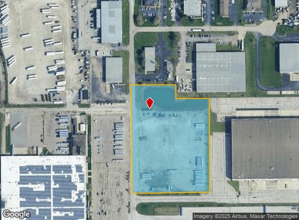
235 Transfer Dr
49-12-03-116-008.000-900
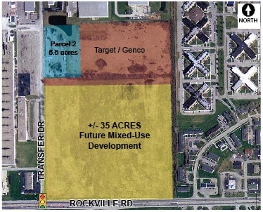
EG 6.94 AC
Industrialgeneral
Marion
X
Indiana
18097C0118F
6.94 AC
2023
Speedway
2024
Indianapolis
340102
Indianapolis-Carmel-Anderson, IN
DEMOGRAPHICS near 235 Transfer Dr
1 Mile
3 Mile
5 Mile
2024 Total Population
8,194
78,104
188,077
2029 Population
8,033
78,460
190,981
Pop Growth 2024-2029
(1.96%)
+ 0.46%
+ 1.54%
Average Age
40
37
36
2024 Total Households
3,478
30,702
71,809
HH Growth 2024-2029
(1.75%)
+ 0.26%
+ 1.31%
Median Household Inc
$52,466
$56,634
$56,353
Avg Household Size
2.30
2.50
2.50
2024 Avg HH Vehicles
1.00
2.00
2.00
Median Home Value
$157,223
$159,893
$157,773
Median Year Built
1971
1980
1977
Nearby Places
- Restaurants
- Banks
- Shops
- Fitness
- Groceries
PUBLIC TRANSPORTATION
COMMUTER RAIL
Indianapolis (Cardinal - Amtrak)
DRIVE
WALK
Distance
Indianapolis (Cardinal - Amtrak)
15 min
8.2 mi
AIRPORT
Indianapolis International
DRIVE
WALK
Distance
Indianapolis International
20 min
8.4 mi
Freight Ports
Port of Toledo
DRIVE
WALK
Distance
Port of Toledo
284 min
233.1 mi
SALE & LEASE HISTORY
LISTING DATE
SALE/LEASE

Sep 25, 2016
For Lease
Nearby Properties
Address
Land Use
TOTAL SIZE
Lot Size
Zoning
Address
Land Use
TOTAL SIZE
Lot Size
Zoning
1,340,481 SF
63.99 AC
ZO01
Address
Land Use
TOTAL SIZE
Lot Size
Zoning
52.77 AC
Address
Land Use
TOTAL SIZE
Lot Size
Zoning
315,254 SF
48.71 AC
Address
Land Use
TOTAL SIZE
Lot Size
Zoning
6,486 SF
17.63 AC
Address
Land Use
TOTAL SIZE
Lot Size
Zoning
5,280 SF
97.87 AC
ZO01
Address
Land Use
TOTAL SIZE
Lot Size
Zoning
18,072 SF
29.73 AC
Address
Land Use
TOTAL SIZE
Lot Size
Zoning
1,413,414 SF
115.43 AC
ZO01
Address
Land Use
TOTAL SIZE
Lot Size
Zoning
145,816 SF
1.07 AC
Address
Land Use
TOTAL SIZE
Lot Size
Zoning
415,877 SF
55.83 AC
ZO01
Address
Land Use
TOTAL SIZE
Lot Size
Zoning
9,750 SF
43.46 AC
ZO01
Address
Land Use
TOTAL SIZE
Lot Size
Zoning
3,518 SF
16.76 AC
Address
Land Use
TOTAL SIZE
Lot Size
Zoning
578,964 SF
35.50 AC
ZO01
Address
Land Use
TOTAL SIZE
Lot Size
Zoning
27,327 SF
15 AC
Address
Land Use
TOTAL SIZE
Lot Size
Zoning
19,314 SF
32.88 AC
ZO01
Address
Land Use
TOTAL SIZE
Lot Size
Zoning
2,737 SF
9.65 AC
Address
Land Use
TOTAL SIZE
Lot Size
Zoning
3,878 SF
17.76 AC
Address
Land Use
TOTAL SIZE
Lot Size
Zoning
7,364 SF
9.20 AC
Address
Land Use
TOTAL SIZE
Lot Size
Zoning
Address
Land Use
TOTAL SIZE
Lot Size
Zoning
3,618 SF
31.13 AC
ZO01
Address
Land Use
TOTAL SIZE
Lot Size
Zoning
30,545 SF
3.41 AC
ZO01
Address
Land Use
TOTAL SIZE
Lot Size
Zoning
3,706 SF
30.57 AC
ZO01
Address
Land Use
TOTAL SIZE
Lot Size
Zoning
1,868 SF
14.50 AC
ZO01
Address
Land Use
TOTAL SIZE
Lot Size
Zoning
28,400 SF
22.04 AC
ZO01
Address
Land Use
TOTAL SIZE
Lot Size
Zoning
1,700 SF
40.37 AC
ZO01
Address
Land Use
TOTAL SIZE
Lot Size
Zoning
5,616 SF
9.34 AC
Address
Land Use
TOTAL SIZE
Lot Size
Zoning
2,288 SF
21.42 AC
Address
Land Use
TOTAL SIZE
Lot Size
Zoning
3,802 SF
12.25 AC
Address
Land Use
TOTAL SIZE
Lot Size
Zoning
120,734 SF
21.48 AC
Address
Land Use
TOTAL SIZE
Lot Size
Zoning
641,389 SF
44.90 AC
Address
Land Use
TOTAL SIZE
Lot Size
Zoning
216,914 SF
29.32 AC
The World's #1 Commercial Real Estate Marketplace
Connect with us
© 2025 CoStar Group
The information above has been obtained from sources believed reliable. While we do not doubt its accuracy we have not verified it and make no guarantee, warranty or representation about it. It is your responsibility to independently confirm its accuracy and completeness. Any projections, opinions, assumptions, or estimates used are for example only and do not represent the current or future performance of the property. The value of this transaction to you depends on tax and other factors which should be evaluated by your tax, financial, and legal advisors. You and your advisors should conduct a careful, independent investigation of the property to determine to your satisfaction the suitability of the property for your needs.