Property Record
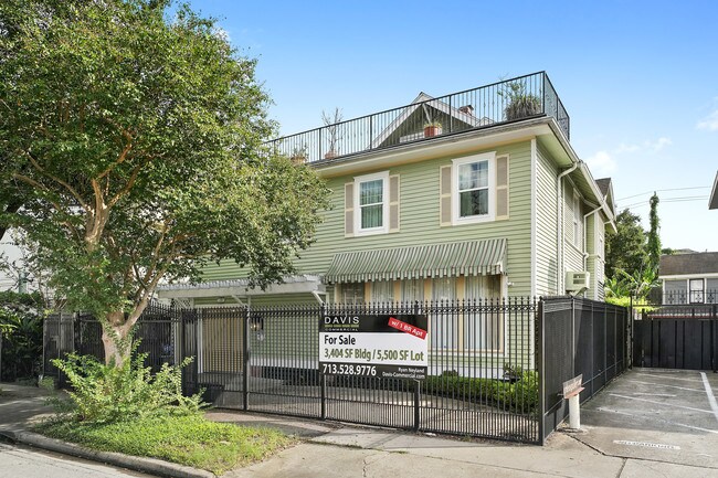
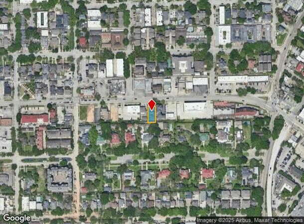
235 Westheimer Rd, Houston, TX 77006
NEARBY LISTINGS FOR SALE OR LEASE
Property Detail
235 Westheimer Rd
Houston-The Woodlands-Sugar Land, TX
Avondale
0041410000017
Harris
Duplex
Texas
X
0.13 AC
48201C0860L
Montrose
5,286 SF
Houston
DEMOGRAPHICS near 235 Westheimer Rd
1 Mile
3 Mile
5 Mile
2024 Total Population
37,761
231,017
510,675
2029 Population
39,382
241,077
531,359
Pop Growth 2024-2029
+ 4.29%
+ 4.35%
+ 4.05%
Average Age
37
37
38
2024 Total Households
21,565
110,654
236,901
HH Growth 2024-2029
+ 4.30%
+ 4.73%
+ 4.27%
Median Household Inc
$86,131
$94,370
$82,844
Avg Household Size
1.60
1.80
2.00
2024 Avg HH Vehicles
1.00
1.00
2.00
Median Home Value
$442,697
$474,172
$450,255
Median Year Built
2002
2002
1995
Nearby Places
Map Layers
Map Styles
 Street
 Aerial
- Restaurants
- Banks
- Shops
- Fitness
- Groceries
PUBLIC TRANSPORTATION
TRANSIT/SUBWAY
Ensemble/Hcc (METRORAIL RED LINE - Metropolitan Transit Authority of Harris County, Redline - Metropolitan Transit Authority of Harris County)
DRIVE
WALK
Distance
Ensemble/Hcc (METRORAIL RED LINE - Metropolitan Transit Authority of Harris County, Redline - Metropolitan Transit Authority of Harris County)
1 min
12 min
0.6 mi
Ensemble/Hcc Stn Sb (METRORAIL RED LINE - Metropolitan Transit Authority of Harris County)
DRIVE
WALK
Distance
Ensemble/Hcc Stn Sb (METRORAIL RED LINE - Metropolitan Transit Authority of Harris County)
1 min
12 min
0.7 mi
Mcgowen (METRORAIL RED LINE - Metropolitan Transit Authority of Harris County, Redline - Metropolitan Transit Authority of Harris County)
DRIVE
WALK
Distance
Mcgowen (METRORAIL RED LINE - Metropolitan Transit Authority of Harris County, Redline - Metropolitan Transit Authority of Harris County)
1 min
15 min
0.8 mi
COMMUTER RAIL
Houston (Sunset Limited - Amtrak)
DRIVE
WALK
Distance
Houston (Sunset Limited - Amtrak)
5 min
2.3 mi
AIRPORT
William P Hobby
DRIVE
WALK
Distance
William P Hobby
24 min
12.2 mi
George Bush Intcntl/Houston
DRIVE
WALK
Distance
George Bush Intcntl/Houston
29 min
22.0 mi
Freight Ports
Port of Houston
DRIVE
WALK
Distance
Port of Houston
21 min
11.6 mi
SALE & LEASE HISTORY
LISTING DATE
SALE/LEASE

Oct 17, 2019
For Sale
Mar 06, 2023
For Sale
Feb 07, 2023
For Sale
Feb 07, 2023
For Sale
Dec 14, 2021
For Sale
Aug 30, 2022
For Sale
Apr 03, 2025
For Sale
Nearby Properties
Address
Land Use
TOTAL SIZE
Lot Size
Zoning
Address
Land Use
TOTAL SIZE
Lot Size
Zoning
1,383,720 SF
1.47 AC
Address
Land Use
TOTAL SIZE
Lot Size
Zoning
1,101,686 SF
1.45 AC
Address
Land Use
TOTAL SIZE
Lot Size
Zoning
973,861 SF
1.18 AC
Address
Land Use
TOTAL SIZE
Lot Size
Zoning
899,279 SF
1.18 AC
Address
Land Use
TOTAL SIZE
Lot Size
Zoning
797,208 SF
1.46 AC
Address
Land Use
TOTAL SIZE
Lot Size
Zoning
519,409 SF
1.52 AC
Address
Land Use
TOTAL SIZE
Lot Size
Zoning
1,916,394 SF
1.46 AC
Address
Land Use
TOTAL SIZE
Lot Size
Zoning
1,871,418 SF
1.44 AC
Address
Land Use
TOTAL SIZE
Lot Size
Zoning
1,252,274 SF
2.02 AC
Address
Land Use
TOTAL SIZE
Lot Size
Zoning
1,880,742 SF
20.77 AC
Address
Land Use
TOTAL SIZE
Lot Size
Zoning
1,091,726 SF
2.60 AC
Address
Land Use
TOTAL SIZE
Lot Size
Zoning
1,232,364 SF
1.49 AC
Address
Land Use
TOTAL SIZE
Lot Size
Zoning
1,436,400 SF
1.44 AC
Address
Land Use
TOTAL SIZE
Lot Size
Zoning
1,321,033 SF
1.46 AC
Address
Land Use
TOTAL SIZE
Lot Size
Zoning
4,169,721 SF
31.23 AC
Address
Land Use
TOTAL SIZE
Lot Size
Zoning
2,005,097 SF
1.44 AC
Address
Land Use
TOTAL SIZE
Lot Size
Zoning
1,374,271 SF
1.44 AC
Address
Land Use
TOTAL SIZE
Lot Size
Zoning
1,150,681 SF
1.17 AC
Address
Land Use
TOTAL SIZE
Lot Size
Zoning
515,025 SF
1.50 AC
Address
Land Use
TOTAL SIZE
Lot Size
Zoning
704,249 SF
2.34 AC
Address
Land Use
TOTAL SIZE
Lot Size
Zoning
1,657,484 SF
1.44 AC
Address
Land Use
TOTAL SIZE
Lot Size
Zoning
1,282,908 SF
2.74 AC
Address
Land Use
TOTAL SIZE
Lot Size
Zoning
1,311,133 SF
1.44 AC
Address
Land Use
TOTAL SIZE
Lot Size
Zoning
555,351 SF
1.40 AC
Address
Land Use
TOTAL SIZE
Lot Size
Zoning
1,181,384 SF
1.47 AC
Address
Land Use
TOTAL SIZE
Lot Size
Zoning
1,044,305 SF
3.16 AC
Address
Land Use
TOTAL SIZE
Lot Size
Zoning
1,162,204 SF
1.44 AC
Address
Land Use
TOTAL SIZE
Lot Size
Zoning
934,258 SF
1.45 AC
Address
Land Use
TOTAL SIZE
Lot Size
Zoning
1,103,424 SF
1.44 AC
Address
Land Use
TOTAL SIZE
Lot Size
Zoning
1,365,801 SF
1.44 AC
The World's #1 Commercial Real Estate Marketplace
Connect with us
© 2025 CoStar Group
The information above has been obtained from sources believed reliable. While we do not doubt its accuracy we have not verified it and make no guarantee, warranty or representation about it. It is your responsibility to independently confirm its accuracy and completeness. Any projections, opinions, assumptions, or estimates used are for example only and do not represent the current or future performance of the property. The value of this transaction to you depends on tax and other factors which should be evaluated by your tax, financial, and legal advisors. You and your advisors should conduct a careful, independent investigation of the property to determine to your satisfaction the suitability of the property for your needs.