Property Record
2350 Chestnut Rd, Longs, SC 29568


Save to a Folder
{{folder.Name}}
{{folder.ListingIds.length}} Properties
{{folder.ListingIds.length}} Property
Create a New Folder
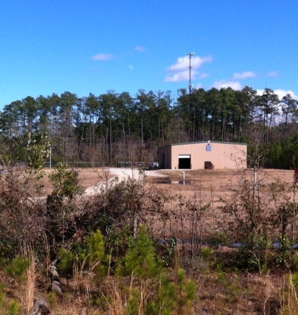
Property Detail
2350 Chestnut Rd
34512020001
E/S HWY 22; TRACT 2
Warehouse
HORRY
B and X Area of moderate flood hazard, usually the area between the limits of the 100-year and 500-year floods.
South Carolina
2025
5.56 AC
2025
Outlying Horry County
060310
Myrtle Beach/Conway
6,000 SF
Myrtle Beach-Conway-North Myrtle Beach, SC
NEARBY LISTINGS FOR SALE OR LEASE
-
-
View all Longs listings for lease on LoopNet.com
DEMOGRAPHICS near 2350 Chestnut Rd
1 mile
3 mile
5 mile
2025 Total Population
1,023
3,242
15,592
2030 Population
1,202
3,695
18,245
Pop Growth 2025-2030
+ 17.50%
+ 13.97%
+ 17.02%
Average Age
42
42
50
2025 Total Households
436
1,318
6,943
HH Growth 2025-2030
+ 17.66%
+ 14.11%
+ 17.53%
Median Household Inc
$74,890
$55,752
$78,694
Avg Household Size
2.20
2.40
2.20
2025 Avg HH Vehicles
2.00
2.00
2.00
Median Home Value
$320,370
$192,272
$363,614
Median Year Built
2010
2006
2008
Nearby Places
Map Layers
Map Styles
 Street
 Aerial
Layers
 Traffic
 Biking
Places
Listings with unknown addresses are not visible on the map
- Restaurants
- Banks
- Shops
- Fitness
- Groceries
PUBLIC TRANSPORTATION
AIRPORT
Myrtle Beach International
Drive
Walk
Distance
Myrtle Beach International
35 min
21.1 mi
SALE & LEASE HISTORY
LISTING DATE
SALE/LEASE

Sep 25, 2016
For Lease
Sep 24, 2016
For Sale
Nearby Properties
Address
Land Use
TOTAL SIZE
Lot Size
Zoning
Address
Land Use
TOTAL SIZE
Lot Size
Zoning
8,189 SF
160.62 AC
Address
Land Use
TOTAL SIZE
Lot Size
Zoning
522.18 AC
Address
Land Use
TOTAL SIZE
Lot Size
Zoning
1,761.51 AC
Address
Land Use
TOTAL SIZE
Lot Size
Zoning
23,835 SF
13.06 AC
Address
Land Use
TOTAL SIZE
Lot Size
Zoning
12,000 SF
2.93 AC
Address
Land Use
TOTAL SIZE
Lot Size
Zoning
15,472 SF
9.38 AC
Address
Land Use
TOTAL SIZE
Lot Size
Zoning
256 SF
116.90 AC
Address
Land Use
TOTAL SIZE
Lot Size
Zoning
696.58 AC
Address
Land Use
TOTAL SIZE
Lot Size
Zoning
760.82 AC
Address
Land Use
TOTAL SIZE
Lot Size
Zoning
4,900 SF
23.07 AC
Address
Land Use
TOTAL SIZE
Lot Size
Zoning
1,120 SF
553.77 AC
Address
Land Use
TOTAL SIZE
Lot Size
Zoning
3,012 SF
5.97 AC
Address
Land Use
TOTAL SIZE
Lot Size
Zoning
15,125 SF
6.17 AC
Address
Land Use
TOTAL SIZE
Lot Size
Zoning
8,212 SF
1.46 AC
Address
Land Use
TOTAL SIZE
Lot Size
Zoning
6,329 SF
1.21 AC
Address
Land Use
TOTAL SIZE
Lot Size
Zoning
18.99 AC
Address
Land Use
TOTAL SIZE
Lot Size
Zoning
1,200 SF
7.90 AC
Address
Land Use
TOTAL SIZE
Lot Size
Zoning
13.61 AC
Address
Land Use
TOTAL SIZE
Lot Size
Zoning
8,050 SF
0.73 AC
Address
Land Use
TOTAL SIZE
Lot Size
Zoning
7,800 SF
0.77 AC
Address
Land Use
TOTAL SIZE
Lot Size
Zoning
4,000 SF
1.06 AC
Address
Land Use
TOTAL SIZE
Lot Size
Zoning
4,147 SF
1.03 AC
Address
Land Use
TOTAL SIZE
Lot Size
Zoning
3,668 SF
0.95 AC
Address
Land Use
TOTAL SIZE
Lot Size
Zoning
4,994 SF
0.75 AC
Address
Land Use
TOTAL SIZE
Lot Size
Zoning
3,750 SF
0.89 AC
Address
Land Use
TOTAL SIZE
Lot Size
Zoning
21.61 AC
The World's #1 Commercial Real Estate Marketplace
Connect with us
© 2026 CoStar Group
The information above has been obtained from sources believed reliable. While we do not doubt its accuracy we have not verified it and make no guarantee, warranty or representation about it. It is your responsibility to independently confirm its accuracy and completeness. Any projections, opinions, assumptions, or estimates used are for example only and do not represent the current or future performance of the property. The value of this transaction to you depends on tax and other factors which should be evaluated by your tax, financial, and legal advisors. You and your advisors should conduct a careful, independent investigation of the property to determine to your satisfaction the suitability of the property for your needs.