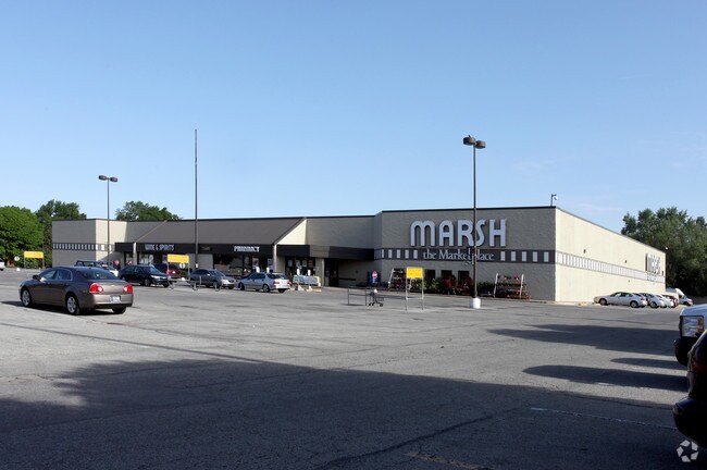
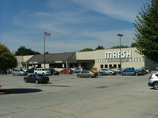
Property Record
2350 E 62Nd St, Indianapolis, IN 46220

NEARBY LISTINGS FOR SALE OR LEASE
Property Detail
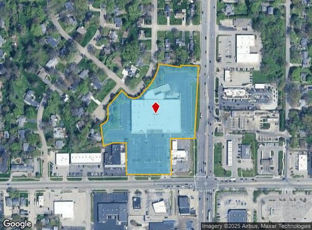
2350 E 62Nd St
Indianapolis-Carmel-Anderson, IN
Chases Broad Ripple Add
49-02-31-113-008.000-801
CHASES BROAD RIPPLE ADD BLOCK A
Supermarket
Marion
X
Indiana
18097C0151G
17
2023
5.48 AC
2024
Keystone Crossing
320600
Indianapolis
57,144 SF
DEMOGRAPHICS near 2350 E 62Nd St
1 Mile
3 Mile
5 Mile
2024 Total Population
10,014
72,379
221,444
2029 Population
9,818
71,561
221,307
Pop Growth 2024-2029
(1.96%)
(1.13%)
(0.06%)
Average Age
39
40
38
2024 Total Households
5,056
33,036
97,231
HH Growth 2024-2029
(2.18%)
(1.26%)
(0.18%)
Median Household Inc
$92,540
$89,226
$62,071
Avg Household Size
1.90
2.10
2.20
2024 Avg HH Vehicles
2.00
2.00
2.00
Median Home Value
$261,458
$298,762
$253,801
Median Year Built
1957
1958
1965
Nearby Places
Map Layers
Map Styles
 Street
 Aerial
- Restaurants
- Banks
- Shops
- Fitness
- Groceries
PUBLIC TRANSPORTATION
COMMUTER RAIL
Indianapolis (Cardinal - Amtrak)
DRIVE
WALK
Distance
Indianapolis (Cardinal - Amtrak)
18 min
9.3 mi
AIRPORT
Indianapolis International
DRIVE
WALK
Distance
Indianapolis International
39 min
22.3 mi
Freight Ports
Port of Toledo
DRIVE
WALK
Distance
Port of Toledo
260 min
218.4 mi
SALE & LEASE HISTORY
LISTING DATE
SALE/LEASE

Sep 28, 2016
For Sale
Oct 01, 2019
For Lease
Mar 16, 2017
For Sale
Nearby Properties
Address
Land Use
TOTAL SIZE
Lot Size
Zoning
Address
Land Use
TOTAL SIZE
Lot Size
Zoning
4,146 SF
45.91 AC
ZO01
Address
Land Use
TOTAL SIZE
Lot Size
Zoning
345 SF
6.39 AC
ZO01
Address
Land Use
TOTAL SIZE
Lot Size
Zoning
8,157 SF
113.93 AC
ZO01
Address
Land Use
TOTAL SIZE
Lot Size
Zoning
143,890 SF
37.81 AC
ZO01
Address
Land Use
TOTAL SIZE
Lot Size
Zoning
50,698 SF
13.58 AC
Address
Land Use
TOTAL SIZE
Lot Size
Zoning
76,657 SF
9.45 AC
ZO01
Address
Land Use
TOTAL SIZE
Lot Size
Zoning
272,688 SF
14.60 AC
ZO01
Address
Land Use
TOTAL SIZE
Lot Size
Zoning
2,156 SF
0.46 AC
ZO01
Address
Land Use
TOTAL SIZE
Lot Size
Zoning
2,142 SF
9.91 AC
ZO01
Address
Land Use
TOTAL SIZE
Lot Size
Zoning
1,024 SF
5.28 AC
ZO01
Address
Land Use
TOTAL SIZE
Lot Size
Zoning
2.81 AC
ZO01
Address
Land Use
TOTAL SIZE
Lot Size
Zoning
13,789 SF
3.93 AC
ZO01
Address
Land Use
TOTAL SIZE
Lot Size
Zoning
2,313 SF
35.45 AC
ZO01
Address
Land Use
TOTAL SIZE
Lot Size
Zoning
29,662 SF
17.96 AC
ZO01
Address
Land Use
TOTAL SIZE
Lot Size
Zoning
12,920 SF
7.10 AC
ZO01
Address
Land Use
TOTAL SIZE
Lot Size
Zoning
1,080 SF
19.24 AC
Address
Land Use
TOTAL SIZE
Lot Size
Zoning
98,790 SF
0.18 AC
ZO01
Address
Land Use
TOTAL SIZE
Lot Size
Zoning
5,670 SF
25.69 AC
Address
Land Use
TOTAL SIZE
Lot Size
Zoning
81,511 SF
13.55 AC
Address
Land Use
TOTAL SIZE
Lot Size
Zoning
33,127 SF
11.51 AC
ZO01
Address
Land Use
TOTAL SIZE
Lot Size
Zoning
170,049 SF
12.74 AC
ZO01
Address
Land Use
TOTAL SIZE
Lot Size
Zoning
80,072 SF
32.54 AC
Address
Land Use
TOTAL SIZE
Lot Size
Zoning
1,903 SF
20.77 AC
ZO01
Address
Land Use
TOTAL SIZE
Lot Size
Zoning
9,930 SF
9.10 AC
ZO01
Address
Land Use
TOTAL SIZE
Lot Size
Zoning
2,044 SF
16.53 AC
ZO01
Address
Land Use
TOTAL SIZE
Lot Size
Zoning
7,740 SF
2.04 AC
ZO01
Address
Land Use
TOTAL SIZE
Lot Size
Zoning
63,490 SF
29.07 AC
ZO01
Address
Land Use
TOTAL SIZE
Lot Size
Zoning
2,951 SF
15.45 AC
ZO01
Address
Land Use
TOTAL SIZE
Lot Size
Zoning
17,469 SF
0.87 AC
ZO01
Address
Land Use
TOTAL SIZE
Lot Size
Zoning
46,320 SF
14.93 AC
ZO01
The World's #1 Commercial Real Estate Marketplace
Connect with us
© 2025 CoStar Group
The information above has been obtained from sources believed reliable. While we do not doubt its accuracy we have not verified it and make no guarantee, warranty or representation about it. It is your responsibility to independently confirm its accuracy and completeness. Any projections, opinions, assumptions, or estimates used are for example only and do not represent the current or future performance of the property. The value of this transaction to you depends on tax and other factors which should be evaluated by your tax, financial, and legal advisors. You and your advisors should conduct a careful, independent investigation of the property to determine to your satisfaction the suitability of the property for your needs.