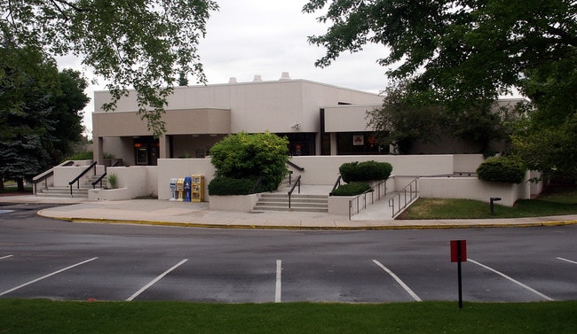
Property Record
2350 E Arapahoe Rd, Littleton, CO 80122
NEARBY LISTINGS FOR SALE OR LEASE
Property Detail
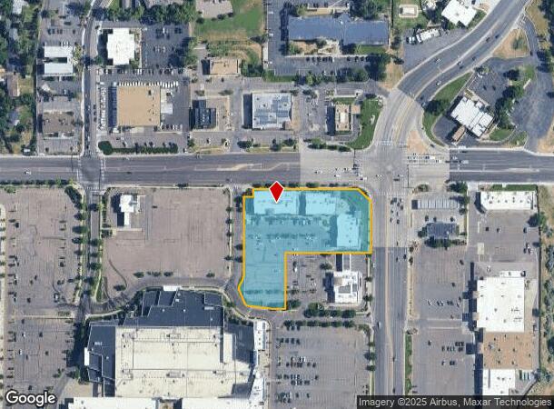
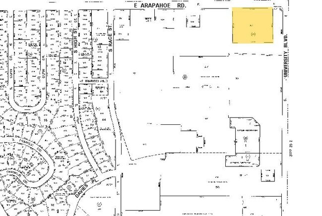
2350 E Arapahoe Rd
Denver-Aurora-Lakewood, CO
Streets At Southglenn 6Th Flg
2077-26-1-35-002
SUBDIVISIONCD 060151 SUBDIVISIONNAME STREETS AT SOUTHGLENN 6TH FLG BLOCK 001 LOT 002 LOT 2 BLK 1 STREETS AT SOUTHGLENN 6TH FLG (A/K/A UNIT 9 SOUTHGLENN MASTER COMMUNITY PER AMENDED MASTER DECLARATION RECORDED AT RECEPTION #D0028223)
Storebuilding
Arapahoe
X
Colorado
08005C0452L
002,2
2023
2.61 AC
2024
Arapahoe Rd
005627
Denver
24,905 SF
DEMOGRAPHICS near 2350 E Arapahoe Rd
1 Mile
3 Mile
5 Mile
2024 Total Population
11,966
100,526
290,601
2029 Population
11,904
102,022
302,474
Pop Growth 2024-2029
(0.52%)
+ 1.49%
+ 4.09%
Average Age
44
43
41
2024 Total Households
4,822
40,216
121,495
HH Growth 2024-2029
(0.58%)
+ 1.62%
+ 3.93%
Median Household Inc
$101,462
$110,137
$107,607
Avg Household Size
2.40
2.40
2.30
2024 Avg HH Vehicles
2.00
2.00
2.00
Median Home Value
$621,833
$664,529
$645,677
Median Year Built
1969
1977
1985
Nearby Places
Map Layers
Map Styles
 Street
 Aerial
- Restaurants
- Banks
- Shops
- Fitness
- Groceries
PUBLIC TRANSPORTATION
AIRPORT
Denver International
DRIVE
WALK
Distance
Denver International
42 min
32.6 mi
Nearby Properties
Address
Land Use
TOTAL SIZE
Lot Size
Zoning
Address
Land Use
TOTAL SIZE
Lot Size
Zoning
390,078 SF
38.27 AC
Address
Land Use
TOTAL SIZE
Lot Size
Zoning
207,637 SF
28.17 AC
PDU
Address
Land Use
TOTAL SIZE
Lot Size
Zoning
167,287 SF
13.65 AC
Address
Land Use
TOTAL SIZE
Lot Size
Zoning
177,772 SF
16 AC
Address
Land Use
TOTAL SIZE
Lot Size
Zoning
163,695 SF
22.90 AC
Address
Land Use
TOTAL SIZE
Lot Size
Zoning
329,937 SF
35.07 AC
PUD
Address
Land Use
TOTAL SIZE
Lot Size
Zoning
572,657 SF
0.21 AC
LPD-C
Address
Land Use
TOTAL SIZE
Lot Size
Zoning
411,924 SF
26.85 AC
LPDI
Address
Land Use
TOTAL SIZE
Lot Size
Zoning
192,108 SF
20.03 AC
Address
Land Use
TOTAL SIZE
Lot Size
Zoning
312,130 SF
20.63 AC
PDU
Address
Land Use
TOTAL SIZE
Lot Size
Zoning
250,402 SF
21 AC
Address
Land Use
TOTAL SIZE
Lot Size
Zoning
196,318 SF
4.50 AC
ARP
Address
Land Use
TOTAL SIZE
Lot Size
Zoning
206,632 SF
33.68 AC
Address
Land Use
TOTAL SIZE
Lot Size
Zoning
61,607 SF
11.60 AC
LPD-C
Address
Land Use
TOTAL SIZE
Lot Size
Zoning
463,840 SF
17.63 AC
PDU
Address
Land Use
TOTAL SIZE
Lot Size
Zoning
146,156 SF
4.61 AC
Address
Land Use
TOTAL SIZE
Lot Size
Zoning
248,058 SF
12.24 AC
Address
Land Use
TOTAL SIZE
Lot Size
Zoning
677,688 SF
2.97 AC
Address
Land Use
TOTAL SIZE
Lot Size
Zoning
152,384 SF
12.89 AC
PDU
Address
Land Use
TOTAL SIZE
Lot Size
Zoning
319,593 SF
12.78 AC
PUD
Address
Land Use
TOTAL SIZE
Lot Size
Zoning
255,868 SF
35.96 AC
Address
Land Use
TOTAL SIZE
Lot Size
Zoning
146,877 SF
11.52 AC
Address
Land Use
TOTAL SIZE
Lot Size
Zoning
128,655 SF
16.18 AC
AI1
Address
Land Use
TOTAL SIZE
Lot Size
Zoning
68,000 SF
7.47 AC
Address
Land Use
TOTAL SIZE
Lot Size
Zoning
143,303 SF
19.83 AC
Address
Land Use
TOTAL SIZE
Lot Size
Zoning
80,576 SF
11.44 AC
Address
Land Use
TOTAL SIZE
Lot Size
Zoning
131,886 SF
8.39 AC
Address
Land Use
TOTAL SIZE
Lot Size
Zoning
99,288 SF
2.62 AC
Address
Land Use
TOTAL SIZE
Lot Size
Zoning
40,343 SF
4.37 AC
Address
Land Use
TOTAL SIZE
Lot Size
Zoning
308,385 SF
2.19 AC
The World's #1 Commercial Real Estate Marketplace
Connect with us
© 2025 CoStar Group
The information above has been obtained from sources believed reliable. While we do not doubt its accuracy we have not verified it and make no guarantee, warranty or representation about it. It is your responsibility to independently confirm its accuracy and completeness. Any projections, opinions, assumptions, or estimates used are for example only and do not represent the current or future performance of the property. The value of this transaction to you depends on tax and other factors which should be evaluated by your tax, financial, and legal advisors. You and your advisors should conduct a careful, independent investigation of the property to determine to your satisfaction the suitability of the property for your needs.