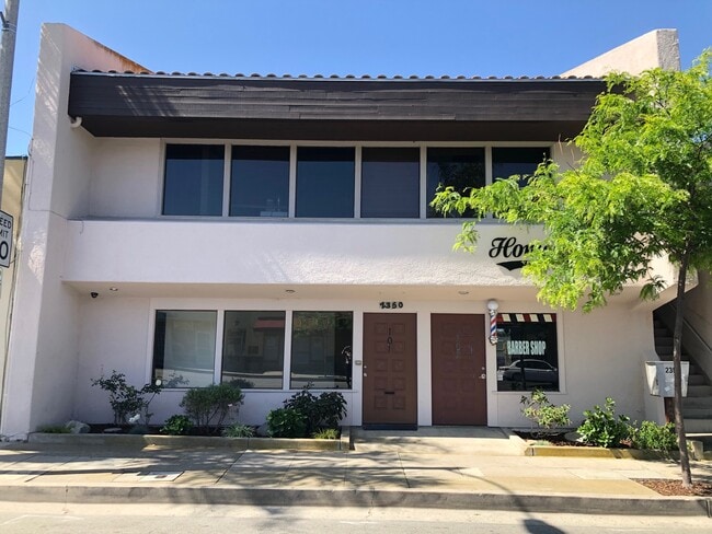
Property Record
2350 E Main St, Ventura, CA 93003


Current Lease Availabilities
Property Detail
2350 E Main St
075-0-021-030
LOT: 104 REF: 012MR 047
Officebuilding
Ventura
C1
California
B and X Area of moderate flood hazard, usually the area between the limits of the 100-year and 500-year floods.
104
2024
0.12 AC
2025
Ventura
002800
Los Angeles
2,516 SF
Oxnard-Thousand Oaks-Ventura, CA
NEARBY LISTINGS FOR SALE OR LEASE
DEMOGRAPHICS near 2350 E Main St
1 mile
3 mile
5 mile
2025 Total Population
14,042
62,556
95,086
2030 Population
14,026
62,926
95,264
Pop Growth 2025-2030
(0.11%)
+ 0.59%
+ 0.19%
Average Age
44
42
43
2025 Total Households
5,965
24,830
36,454
HH Growth 2025-2030
(0.20%)
+ 0.59%
+ 0.18%
Median Household Inc
$110,370
$95,907
$101,468
Avg Household Size
2.30
2.40
2.50
2025 Avg HH Vehicles
2.00
2.00
2.00
Median Home Value
$1,013,132
$853,707
$828,325
Median Year Built
1952
1967
1970
Nearby Places
Map Layers
Map Styles
 Street
 Aerial
Transit
 Traffic
 Biking
Places
Listings with unknown addresses are not visible on the map
- Restaurants
- Banks
- Shops
- Fitness
- Groceries
PUBLIC TRANSPORTATION
COMMUTER RAIL
Drive
Walk
Distance
8 min
2.8 mi
Drive
Walk
Distance
8 min
4.2 mi
AIRPORT
Santa Barbara Municipal
Drive
Walk
Distance
Santa Barbara Municipal
64 min
41.2 mi
Freight Ports
The Port of Hueneme
Drive
Walk
Distance
The Port of Hueneme
22 min
11.9 mi
Nearby Properties
Address
Land Use
TOTAL SIZE
Lot Size
Zoning
Address
Land Use
TOTAL SIZE
Lot Size
Zoning
1.99 AC
Address
Land Use
TOTAL SIZE
Lot Size
Zoning
4.19 AC
H
Address
Land Use
TOTAL SIZE
Lot Size
Zoning
233,168 SF
13.94 AC
RPD-
Address
Land Use
TOTAL SIZE
Lot Size
Zoning
176,598 SF
9.22 AC
Address
Land Use
TOTAL SIZE
Lot Size
Zoning
Address
Land Use
TOTAL SIZE
Lot Size
Zoning
49,296 SF
11.08 AC
Address
Land Use
TOTAL SIZE
Lot Size
Zoning
7,280 SF
5.38 AC
C-T-O
Address
Land Use
TOTAL SIZE
Lot Size
Zoning
3.01 AC
Address
Land Use
TOTAL SIZE
Lot Size
Zoning
40,110 SF
8.04 AC
MPD
Address
Land Use
TOTAL SIZE
Lot Size
Zoning
6.81 AC
C-T-O
Address
Land Use
TOTAL SIZE
Lot Size
Zoning
2.89 AC
C-T-O
Address
Land Use
TOTAL SIZE
Lot Size
Zoning
13,530 SF
10.85 AC
Address
Land Use
TOTAL SIZE
Lot Size
Zoning
25,401 SF
2.74 AC
C1AD
Address
Land Use
TOTAL SIZE
Lot Size
Zoning
81,671 SF
3.54 AC
Address
Land Use
TOTAL SIZE
Lot Size
Zoning
639.79 AC
Address
Land Use
TOTAL SIZE
Lot Size
Zoning
107,360 SF
5.96 AC
RPD15
Address
Land Use
TOTAL SIZE
Lot Size
Zoning
73,272 SF
6.05 AC
C1AD
Address
Land Use
TOTAL SIZE
Lot Size
Zoning
58,841 SF
6.74 AC
CPD
Address
Land Use
TOTAL SIZE
Lot Size
Zoning
76,449 SF
6.88 AC
CPD
Address
Land Use
TOTAL SIZE
Lot Size
Zoning
65,192 SF
3.20 AC
RPD-
Address
Land Use
TOTAL SIZE
Lot Size
Zoning
3.26 AC
PO
Address
Land Use
TOTAL SIZE
Lot Size
Zoning
96,277 SF
7.72 AC
Address
Land Use
TOTAL SIZE
Lot Size
Zoning
68,148 SF
3.75 AC
P-O
Address
Land Use
TOTAL SIZE
Lot Size
Zoning
51,078 SF
1.73 AC
Address
Land Use
TOTAL SIZE
Lot Size
Zoning
7,993 SF
3.71 AC
C-T-O
Address
Land Use
TOTAL SIZE
Lot Size
Zoning
7,233 SF
7.39 AC
C1
Address
Land Use
TOTAL SIZE
Lot Size
Zoning
Address
Land Use
TOTAL SIZE
Lot Size
Zoning
13,996 SF
1.09 AC
The World's #1 Commercial Real Estate Marketplace
Connect with us
© 2026 CoStar Group
The information above has been obtained from sources believed reliable. While we do not doubt its accuracy we have not verified it and make no guarantee, warranty or representation about it. It is your responsibility to independently confirm its accuracy and completeness. Any projections, opinions, assumptions, or estimates used are for example only and do not represent the current or future performance of the property. The value of this transaction to you depends on tax and other factors which should be evaluated by your tax, financial, and legal advisors. You and your advisors should conduct a careful, independent investigation of the property to determine to your satisfaction the suitability of the property for your needs.