Property Record
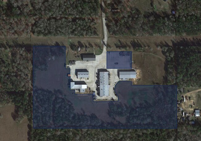
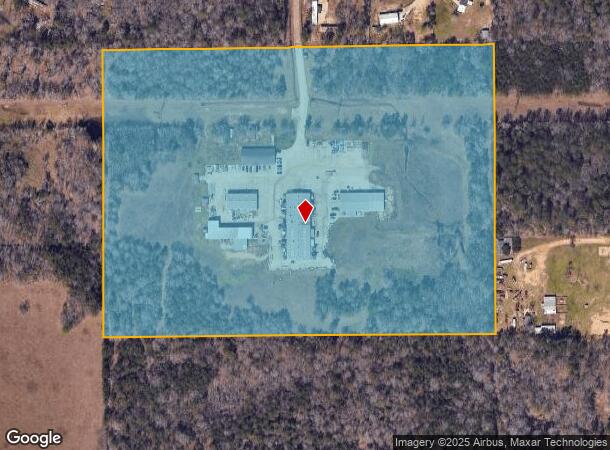
2350 Security Forest Dr, Conroe, TX 77306
Property Detail
2350 Security Forest Dr
0595-00-08100
A0595 WRENTMORE E, TRACT 81-83,85,86,105(AKA LTS 49,50,57,58,65,66 SECURITY 01), ACRES 28.9970
Industrialgeneral
MONTGOMERY
1
Texas
B and X Area of moderate flood hazard, usually the area between the limits of the 100-year and 500-year floods.
50
2024
29 AC
2025
Outlying Montgomery Cnty
693002
Houston
45,629 SF
Houston-Pasadena-The Woodlands, TX
NEARBY LISTINGS FOR SALE OR LEASE
DEMOGRAPHICS near 2350 Security Forest Dr
1 mile
3 mile
5 mile
2024 Total Population
715
7,766
21,893
2029 Population
858
9,214
25,948
Pop Growth 2024-2029
+ 20.00%
+ 18.65%
+ 18.52%
Average Age
37
36
36
2024 Total Households
237
2,436
6,874
HH Growth 2024-2029
+ 20.68%
+ 19.21%
+ 19.07%
Median Household Inc
$54,125
$55,047
$57,413
Avg Household Size
3.00
3.10
3.10
2024 Avg HH Vehicles
2.00
2.00
2.00
Median Home Value
$311,538
$209,201
$214,756
Median Year Built
2006
2002
2004
Nearby Places
Map Layers
Map Styles
 Street
 Aerial
Transit
 Traffic
 Biking
Places
Listings with unknown addresses are not visible on the map
- Restaurants
- Banks
- Shops
- Fitness
- Groceries
PUBLIC TRANSPORTATION
AIRPORT
George Bush Intcntl/Houston
Drive
Walk
Distance
George Bush Intcntl/Houston
55 min
38.8 mi
Freight Ports
Port of Houston
Drive
Walk
Distance
Port of Houston
76 min
54.1 mi
SALE & LEASE HISTORY
LISTING DATE
SALE/LEASE

Dec 09, 2020
For Lease
Nearby Properties
Address
Land Use
TOTAL SIZE
Lot Size
Zoning
Address
Land Use
TOTAL SIZE
Lot Size
Zoning
9,120 SF
2.34 AC
Address
Land Use
TOTAL SIZE
Lot Size
Zoning
50,652 SF
15 AC
1
Address
Land Use
TOTAL SIZE
Lot Size
Zoning
10,200 SF
1.06 AC
Address
Land Use
TOTAL SIZE
Lot Size
Zoning
9,000 SF
1.15 AC
Address
Land Use
TOTAL SIZE
Lot Size
Zoning
39,356 SF
15 AC
1
Address
Land Use
TOTAL SIZE
Lot Size
Zoning
20,060 SF
7.20 AC
1
Address
Land Use
TOTAL SIZE
Lot Size
Zoning
7,725 SF
5.90 AC
1
Address
Land Use
TOTAL SIZE
Lot Size
Zoning
8,252 SF
40.31 AC
1
Address
Land Use
TOTAL SIZE
Lot Size
Zoning
12,928 SF
3.55 AC
1
Address
Land Use
TOTAL SIZE
Lot Size
Zoning
33,170 SF
1.72 AC
1
Address
Land Use
TOTAL SIZE
Lot Size
Zoning
21,090 SF
3 AC
1
Address
Land Use
TOTAL SIZE
Lot Size
Zoning
12,844 SF
3.30 AC
1
Address
Land Use
TOTAL SIZE
Lot Size
Zoning
10,380 SF
1.08 AC
1
Address
Land Use
TOTAL SIZE
Lot Size
Zoning
16,260 SF
3 AC
Address
Land Use
TOTAL SIZE
Lot Size
Zoning
6,592 SF
1.92 AC
Address
Land Use
TOTAL SIZE
Lot Size
Zoning
11,176 SF
4.11 AC
Address
Land Use
TOTAL SIZE
Lot Size
Zoning
7,389 SF
7.20 AC
1
Address
Land Use
TOTAL SIZE
Lot Size
Zoning
9,182 SF
9.24 AC
1
Address
Land Use
TOTAL SIZE
Lot Size
Zoning
293.63 AC
Address
Land Use
TOTAL SIZE
Lot Size
Zoning
5,920 SF
1.01 AC
Address
Land Use
TOTAL SIZE
Lot Size
Zoning
320 SF
44.10 AC
Address
Land Use
TOTAL SIZE
Lot Size
Zoning
59.05 AC
1
Address
Land Use
TOTAL SIZE
Lot Size
Zoning
5,850 SF
2.44 AC
1
Address
Land Use
TOTAL SIZE
Lot Size
Zoning
2,312 SF
17.55 AC
Address
Land Use
TOTAL SIZE
Lot Size
Zoning
6,370 SF
1.01 AC
1
The World's #1 Commercial Real Estate Marketplace
Connect with us
© 2026 CoStar Group
The information above has been obtained from sources believed reliable. While we do not doubt its accuracy we have not verified it and make no guarantee, warranty or representation about it. It is your responsibility to independently confirm its accuracy and completeness. Any projections, opinions, assumptions, or estimates used are for example only and do not represent the current or future performance of the property. The value of this transaction to you depends on tax and other factors which should be evaluated by your tax, financial, and legal advisors. You and your advisors should conduct a careful, independent investigation of the property to determine to your satisfaction the suitability of the property for your needs.