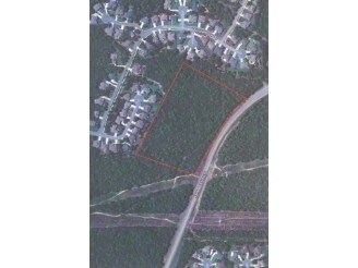
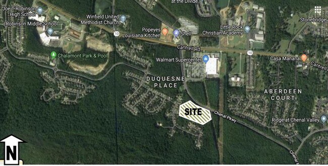
Property Record
23501 Chenal Pkwy, Little Rock, AR 72223

NEARBY LISTINGS FOR SALE OR LEASE
Property Detail
23501 Chenal Pkwy
Little Rock-North Little Rock-Conway, AR
Maumelle Orchard Addition
53L-015-00-001-01
A PART OF LOTS 72, 73, 79, 80, 81, 88, 89, 90, 95 AND 96, MAUMELLE ORCHARD ADDITION LOCATED IN SECTION 15, T-2-N, R-14-W, PULASKI COUNTY, ARKANSAS, MORE PARTICULARLY DESCRIBED AS COMMENCING AT THE SOUTHEAST CORNER OF THE SE1/4 NW1/4 OF SECTION 15, T-
Religious
Pulaski
X
Arkansas
05119C0311H
72,73
2025
10 AC
2025
Outlying Pulaski County
004213
Little Rock/N Little Rock
12,469 SF
DEMOGRAPHICS near 23501 Chenal Pkwy
1 Mile
3 Mile
5 Mile
2024 Total Population
2,927
16,783
42,605
2029 Population
2,924
16,898
42,485
Pop Growth 2024-2029
(0.10%)
+ 0.69%
(0.28%)
Average Age
41
43
42
2024 Total Households
1,305
6,799
17,617
HH Growth 2024-2029
(0.31%)
+ 0.62%
(0.33%)
Median Household Inc
$111,938
$135,939
$107,440
Avg Household Size
2.20
2.40
2.40
2024 Avg HH Vehicles
2.00
2.00
2.00
Median Home Value
$352,739
$392,121
$351,710
Median Year Built
2005
2003
1996
Nearby Places
Map Layers
Map Styles
 Street
 Aerial
- Restaurants
- Banks
- Shops
- Fitness
- Groceries
PUBLIC TRANSPORTATION
AIRPORT
Bill and Hillary Clinton Ntl/Adams Field
DRIVE
WALK
Distance
Bill and Hillary Clinton Ntl/Adams Field
30 min
19.3 mi
Freight Ports
Port of Shreveport
DRIVE
WALK
Distance
Port of Shreveport
257 min
237.8 mi
SALE & LEASE HISTORY
LISTING DATE
SALE/LEASE

Sep 24, 2016
For Sale
Nov 12, 2020
For Sale
Nearby Properties
Address
Land Use
TOTAL SIZE
Lot Size
Zoning
Address
Land Use
TOTAL SIZE
Lot Size
Zoning
361,360 SF
20.01 AC
Address
Land Use
TOTAL SIZE
Lot Size
Zoning
126,536 SF
25.98 AC
Address
Land Use
TOTAL SIZE
Lot Size
Zoning
267,343 SF
52.19 AC
Address
Land Use
TOTAL SIZE
Lot Size
Zoning
82,176 SF
14.83 AC
Address
Land Use
TOTAL SIZE
Lot Size
Zoning
125,107 SF
22.09 AC
Address
Land Use
TOTAL SIZE
Lot Size
Zoning
58,828 SF
15.22 AC
Address
Land Use
TOTAL SIZE
Lot Size
Zoning
115,062 SF
10.04 AC
Address
Land Use
TOTAL SIZE
Lot Size
Zoning
86,186 SF
13.24 AC
Address
Land Use
TOTAL SIZE
Lot Size
Zoning
160,068 SF
18.91 AC
Address
Land Use
TOTAL SIZE
Lot Size
Zoning
217,088 SF
26.89 AC
Address
Land Use
TOTAL SIZE
Lot Size
Zoning
40,803 SF
18.48 AC
Address
Land Use
TOTAL SIZE
Lot Size
Zoning
30,040 SF
10.80 AC
Address
Land Use
TOTAL SIZE
Lot Size
Zoning
93,175 SF
4.74 AC
Address
Land Use
TOTAL SIZE
Lot Size
Zoning
102,990 SF
10.43 AC
Address
Land Use
TOTAL SIZE
Lot Size
Zoning
42,686 SF
22.11 AC
Address
Land Use
TOTAL SIZE
Lot Size
Zoning
103,169 SF
8.32 AC
Address
Land Use
TOTAL SIZE
Lot Size
Zoning
85,980 SF
32.29 AC
Address
Land Use
TOTAL SIZE
Lot Size
Zoning
206,671 SF
26.16 AC
Address
Land Use
TOTAL SIZE
Lot Size
Zoning
91,822 SF
14 AC
Address
Land Use
TOTAL SIZE
Lot Size
Zoning
173,120 SF
67.23 AC
Address
Land Use
TOTAL SIZE
Lot Size
Zoning
99,581 SF
8.11 AC
Address
Land Use
TOTAL SIZE
Lot Size
Zoning
3,470 SF
3.69 AC
Address
Land Use
TOTAL SIZE
Lot Size
Zoning
58,854 SF
7.11 AC
Address
Land Use
TOTAL SIZE
Lot Size
Zoning
61,458 SF
5.50 AC
Address
Land Use
TOTAL SIZE
Lot Size
Zoning
38,617 SF
4.62 AC
Address
Land Use
TOTAL SIZE
Lot Size
Zoning
37,229 SF
4.06 AC
Address
Land Use
TOTAL SIZE
Lot Size
Zoning
71,646 SF
2.75 AC
Address
Land Use
TOTAL SIZE
Lot Size
Zoning
1,614 SF
3.36 AC
Address
Land Use
TOTAL SIZE
Lot Size
Zoning
44,475 SF
5.61 AC
The World's #1 Commercial Real Estate Marketplace
Connect with us
© 2026 CoStar Group
The information above has been obtained from sources believed reliable. While we do not doubt its accuracy we have not verified it and make no guarantee, warranty or representation about it. It is your responsibility to independently confirm its accuracy and completeness. Any projections, opinions, assumptions, or estimates used are for example only and do not represent the current or future performance of the property. The value of this transaction to you depends on tax and other factors which should be evaluated by your tax, financial, and legal advisors. You and your advisors should conduct a careful, independent investigation of the property to determine to your satisfaction the suitability of the property for your needs.