Property Record
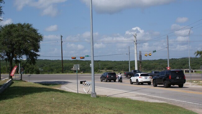
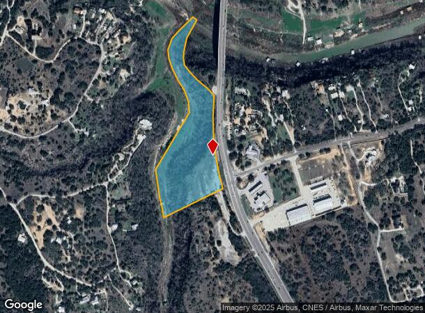
23501 State Highway 71 W, Spicewood, TX 78669
NEARBY LISTINGS FOR SALE OR LEASE
Property Detail
23501 State Highway 71 W
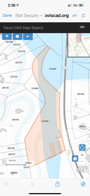
374085
Gritten E
Vacantlandnec
ABS 13 SUR 1 GRITTEN E ACR 13.24
A
Travis
48053C0725F
Texas
2024
13.24 AC
2025
Southwest
036500
Other Market Areas
24,551 SF
Austin-Round Rock, TX
DEMOGRAPHICS near 23501 State Highway 71 W
1 Mile
3 Mile
5 Mile
2024 Total Population
727
5,584
15,554
2029 Population
796
6,093
17,373
Pop Growth 2024-2029
+ 9.49%
+ 9.12%
+ 11.69%
Average Age
42
42
43
2024 Total Households
254
2,003
5,692
HH Growth 2024-2029
+ 10.63%
+ 9.99%
+ 12.47%
Median Household Inc
$139,473
$126,185
$131,170
Avg Household Size
2.80
2.70
2.70
2024 Avg HH Vehicles
2.00
2.00
2.00
Median Home Value
$649,606
$598,669
$662,297
Median Year Built
2007
2005
2008
Nearby Places
Map Layers
Map Styles
 Street
 Aerial
- Restaurants
- Banks
- Shops
- Fitness
- Groceries
PUBLIC TRANSPORTATION
AIRPORT
Austin-Bergstrom International
DRIVE
WALK
Distance
Austin-Bergstrom International
53 min
33.5 mi
Freight Ports
Calhoun Port
DRIVE
WALK
Distance
Calhoun Port
218 min
177.0 mi
SALE & LEASE HISTORY
LISTING DATE
SALE/LEASE

Sep 22, 2021
For Sale
Feb 06, 2024
For Sale
Nearby Properties
Address
Land Use
TOTAL SIZE
Lot Size
Zoning
Address
Land Use
TOTAL SIZE
Lot Size
Zoning
1,159.67 AC
Address
Land Use
TOTAL SIZE
Lot Size
Zoning
574.73 AC
Address
Land Use
TOTAL SIZE
Lot Size
Zoning
76,000 SF
6.50 AC
Address
Land Use
TOTAL SIZE
Lot Size
Zoning
225.11 AC
Address
Land Use
TOTAL SIZE
Lot Size
Zoning
21,068 SF
55.65 AC
Address
Land Use
TOTAL SIZE
Lot Size
Zoning
212.08 AC
Address
Land Use
TOTAL SIZE
Lot Size
Zoning
12,592 SF
24.61 AC
Address
Land Use
TOTAL SIZE
Lot Size
Zoning
12,693 SF
2 AC
Address
Land Use
TOTAL SIZE
Lot Size
Zoning
25,200 SF
10 AC
Address
Land Use
TOTAL SIZE
Lot Size
Zoning
1,064 SF
80 AC
Address
Land Use
TOTAL SIZE
Lot Size
Zoning
4,182 SF
88.78 AC
Address
Land Use
TOTAL SIZE
Lot Size
Zoning
34,339 SF
459.50 AC
Address
Land Use
TOTAL SIZE
Lot Size
Zoning
21,578 SF
8.50 AC
Address
Land Use
TOTAL SIZE
Lot Size
Zoning
22,333 SF
2.46 AC
Address
Land Use
TOTAL SIZE
Lot Size
Zoning
61.57 AC
Address
Land Use
TOTAL SIZE
Lot Size
Zoning
2,352 SF
85.71 AC
Address
Land Use
TOTAL SIZE
Lot Size
Zoning
9,500 SF
12.12 AC
Address
Land Use
TOTAL SIZE
Lot Size
Zoning
8,047 SF
12.80 AC
Address
Land Use
TOTAL SIZE
Lot Size
Zoning
2,175 SF
47.40 AC
Address
Land Use
TOTAL SIZE
Lot Size
Zoning
72.58 AC
Address
Land Use
TOTAL SIZE
Lot Size
Zoning
37,056 SF
3.34 AC
Address
Land Use
TOTAL SIZE
Lot Size
Zoning
9.18 AC
Address
Land Use
TOTAL SIZE
Lot Size
Zoning
17.28 AC
Address
Land Use
TOTAL SIZE
Lot Size
Zoning
17,090 SF
110.36 AC
Address
Land Use
TOTAL SIZE
Lot Size
Zoning
2,175 SF
59.56 AC
Address
Land Use
TOTAL SIZE
Lot Size
Zoning
6,300 SF
8.75 AC
Address
Land Use
TOTAL SIZE
Lot Size
Zoning
8,087 SF
1 AC
Address
Land Use
TOTAL SIZE
Lot Size
Zoning
3,688 SF
35.54 AC
Address
Land Use
TOTAL SIZE
Lot Size
Zoning
7,129 SF
64.09 AC
Address
Land Use
TOTAL SIZE
Lot Size
Zoning
6,809 SF
22.46 AC
The World's #1 Commercial Real Estate Marketplace
Connect with us
© 2025 CoStar Group
The information above has been obtained from sources believed reliable. While we do not doubt its accuracy we have not verified it and make no guarantee, warranty or representation about it. It is your responsibility to independently confirm its accuracy and completeness. Any projections, opinions, assumptions, or estimates used are for example only and do not represent the current or future performance of the property. The value of this transaction to you depends on tax and other factors which should be evaluated by your tax, financial, and legal advisors. You and your advisors should conduct a careful, independent investigation of the property to determine to your satisfaction the suitability of the property for your needs.