Property Record
23518 Coons Rd, Tomball, TX 77375

Save to a Folder
{{folder.Name}}
{{folder.ListingIds.length}} Properties
{{folder.ListingIds.length}} Property
Create a New Folder
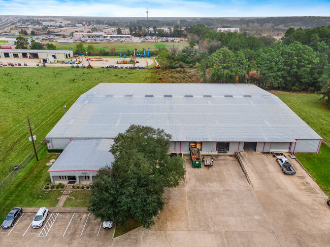
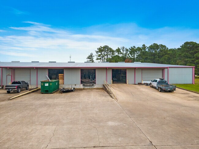
Property Detail
23518 Coons Rd
0440450000058
TR 1M-1 ABST 621 W PERKINS
Warehouse
HARRIS
A Areas with a 1% annual chance of flooding and a 26% chance of flooding over the life of a 30-year mortgage.
Texas
2025
3.38 AC
2025
North Fwy/Tomball Pky
554807
Houston
52,250 SF
Houston-Pasadena-The Woodlands, TX
NEARBY LISTINGS FOR SALE OR LEASE
DEMOGRAPHICS near 23518 Coons Rd
1 mile
3 mile
5 mile
2025 Total Population
9,092
98,830
224,304
2030 Population
9,530
104,673
238,495
Pop Growth 2025-2030
+ 4.82%
+ 5.91%
+ 6.33%
Average Age
36
38
38
2025 Total Households
3,231
33,338
78,361
HH Growth 2025-2030
+ 4.95%
+ 6.09%
+ 6.53%
Median Household Inc
$89,464
$116,303
$102,805
Avg Household Size
2.80
2.90
2.80
2025 Avg HH Vehicles
2.00
2.00
2.00
Median Home Value
$313,579
$349,888
$353,673
Median Year Built
2005
2003
2002
Nearby Places
Map Layers
Map Styles
 Street
 Aerial
Layers
 Traffic
 Biking
Places
Listings with unknown addresses are not visible on the map
- Restaurants
- Banks
- Shops
- Fitness
- Groceries
PUBLIC TRANSPORTATION
AIRPORT
George Bush Intcntl/Houston
Drive
Walk
Distance
George Bush Intcntl/Houston
30 min
23.9 mi
Freight Ports
Port of Houston
Drive
Walk
Distance
Port of Houston
50 min
34.6 mi
SALE & LEASE HISTORY
LISTING DATE
SALE/LEASE

Sep 24, 2016
For Lease
Sep 23, 2016
For Sale
Dec 14, 2021
For Sale
Nearby Properties
Address
Land Use
TOTAL SIZE
Lot Size
Zoning
Address
Land Use
TOTAL SIZE
Lot Size
Zoning
1,648,539 SF
28.70 AC
Address
Land Use
TOTAL SIZE
Lot Size
Zoning
339,067 SF
34.40 AC
Address
Land Use
TOTAL SIZE
Lot Size
Zoning
914,880 SF
50.50 AC
Address
Land Use
TOTAL SIZE
Lot Size
Zoning
1,073,104 SF
4.74 AC
Address
Land Use
TOTAL SIZE
Lot Size
Zoning
749,700 SF
35.22 AC
Address
Land Use
TOTAL SIZE
Lot Size
Zoning
507,035 SF
24.90 AC
Address
Land Use
TOTAL SIZE
Lot Size
Zoning
398,856 SF
12.76 AC
Address
Land Use
TOTAL SIZE
Lot Size
Zoning
263,640 SF
36.62 AC
Address
Land Use
TOTAL SIZE
Lot Size
Zoning
332,688 SF
24.57 AC
Address
Land Use
TOTAL SIZE
Lot Size
Zoning
333,337 SF
21.66 AC
Address
Land Use
TOTAL SIZE
Lot Size
Zoning
294,931 SF
10.94 AC
Address
Land Use
TOTAL SIZE
Lot Size
Zoning
351,343 SF
12.82 AC
Address
Land Use
TOTAL SIZE
Lot Size
Zoning
387,938 SF
16.05 AC
Address
Land Use
TOTAL SIZE
Lot Size
Zoning
393,751 SF
17.08 AC
Address
Land Use
TOTAL SIZE
Lot Size
Zoning
371,761 SF
12.71 AC
Address
Land Use
TOTAL SIZE
Lot Size
Zoning
231,734 SF
8.48 AC
Address
Land Use
TOTAL SIZE
Lot Size
Zoning
80,004 SF
4.41 AC
Address
Land Use
TOTAL SIZE
Lot Size
Zoning
300,080 SF
13.86 AC
Address
Land Use
TOTAL SIZE
Lot Size
Zoning
245,453 SF
10.11 AC
Address
Land Use
TOTAL SIZE
Lot Size
Zoning
314,385 SF
13.78 AC
Address
Land Use
TOTAL SIZE
Lot Size
Zoning
331,691 SF
17.95 AC
Address
Land Use
TOTAL SIZE
Lot Size
Zoning
127,408 SF
3.08 AC
Address
Land Use
TOTAL SIZE
Lot Size
Zoning
177,104 SF
14.30 AC
Address
Land Use
TOTAL SIZE
Lot Size
Zoning
127,570 SF
33.51 AC
Address
Land Use
TOTAL SIZE
Lot Size
Zoning
64,284 SF
4.06 AC
Address
Land Use
TOTAL SIZE
Lot Size
Zoning
235,992 SF
15.94 AC
Address
Land Use
TOTAL SIZE
Lot Size
Zoning
129,174 SF
13.65 AC
Address
Land Use
TOTAL SIZE
Lot Size
Zoning
106,618 SF
12.48 AC
Address
Land Use
TOTAL SIZE
Lot Size
Zoning
223,873 SF
16.55 AC
Address
Land Use
TOTAL SIZE
Lot Size
Zoning
102,710 SF
14.90 AC
The World's #1 Commercial Real Estate Marketplace
Connect with us
© 2026 CoStar Group
The information above has been obtained from sources believed reliable. While we do not doubt its accuracy we have not verified it and make no guarantee, warranty or representation about it. It is your responsibility to independently confirm its accuracy and completeness. Any projections, opinions, assumptions, or estimates used are for example only and do not represent the current or future performance of the property. The value of this transaction to you depends on tax and other factors which should be evaluated by your tax, financial, and legal advisors. You and your advisors should conduct a careful, independent investigation of the property to determine to your satisfaction the suitability of the property for your needs.