Property Record
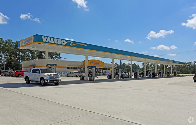
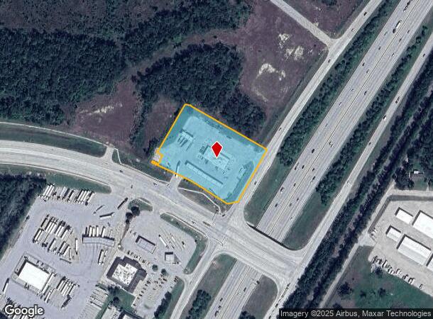
23543 State Highway 242, New Caney, TX 77357

NEARBY LISTINGS FOR SALE OR LEASE
-
-
View all New Caney listings for sale on LoopNet.com
Property Detail
23543 State Highway 242
0552-01-00117
Taylor Wm S
Commercialnec
A0552 - TAYLOR WM S TRACT 1-D (CST CORNER STORE NO 1905 # 2016052654, BLOCK 1, RES A), ACRES 2.9692
X
Montgomery
48339C0600G
Texas
2024
2.97 AC
2025
Montgomery County
692702
Houston
5,900 SF
Houston-The Woodlands-Sugar Land, TX
DEMOGRAPHICS near 23543 State Highway 242
1 Mile
3 Mile
5 Mile
2024 Total Population
1,657
20,359
47,289
2029 Population
2,058
25,602
59,067
Pop Growth 2024-2029
+ 24.20%
+ 25.75%
+ 24.91%
Average Age
39
37
36
2024 Total Households
567
6,688
15,363
HH Growth 2024-2029
+ 24.51%
+ 25.90%
+ 25.02%
Median Household Inc
$83,384
$89,965
$72,811
Avg Household Size
2.90
3.00
3.00
2024 Avg HH Vehicles
3.00
2.00
2.00
Median Home Value
$246,341
$259,315
$224,188
Median Year Built
1998
2006
2002
Nearby Places
Map Layers
Map Styles
 Street
 Aerial
- Restaurants
- Banks
- Shops
- Fitness
- Groceries
PUBLIC TRANSPORTATION
AIRPORT
George Bush Intcntl/Houston
DRIVE
WALK
Distance
George Bush Intcntl/Houston
28 min
22.6 mi
Freight Ports
Port of Houston
DRIVE
WALK
Distance
Port of Houston
49 min
37.8 mi
Nearby Properties
Address
Land Use
TOTAL SIZE
Lot Size
Zoning
Address
Land Use
TOTAL SIZE
Lot Size
Zoning
102,184 SF
20.35 AC
Address
Land Use
TOTAL SIZE
Lot Size
Zoning
68,756 SF
2.10 AC
Address
Land Use
TOTAL SIZE
Lot Size
Zoning
15,368 SF
12.24 AC
Address
Land Use
TOTAL SIZE
Lot Size
Zoning
20,200 SF
26.46 AC
Address
Land Use
TOTAL SIZE
Lot Size
Zoning
55,676 SF
5.40 AC
5
Address
Land Use
TOTAL SIZE
Lot Size
Zoning
3,597 SF
17.87 AC
Address
Land Use
TOTAL SIZE
Lot Size
Zoning
15,638 SF
17.29 AC
5
Address
Land Use
TOTAL SIZE
Lot Size
Zoning
62,486 SF
3.53 AC
5
Address
Land Use
TOTAL SIZE
Lot Size
Zoning
18.30 AC
Address
Land Use
TOTAL SIZE
Lot Size
Zoning
3,880 SF
13.32 AC
5
Address
Land Use
TOTAL SIZE
Lot Size
Zoning
70,376 SF
11.21 AC
5
Address
Land Use
TOTAL SIZE
Lot Size
Zoning
8,432 SF
2.87 AC
Address
Land Use
TOTAL SIZE
Lot Size
Zoning
10,792 SF
2.70 AC
Address
Land Use
TOTAL SIZE
Lot Size
Zoning
237 SF
10.51 AC
5
Address
Land Use
TOTAL SIZE
Lot Size
Zoning
48,400 SF
4.14 AC
Address
Land Use
TOTAL SIZE
Lot Size
Zoning
19,587 SF
3.50 AC
Address
Land Use
TOTAL SIZE
Lot Size
Zoning
50,960 SF
6.06 AC
Address
Land Use
TOTAL SIZE
Lot Size
Zoning
10,870 SF
1.03 AC
Address
Land Use
TOTAL SIZE
Lot Size
Zoning
27,508 SF
4.21 AC
5
Address
Land Use
TOTAL SIZE
Lot Size
Zoning
36,490 SF
2.72 AC
5
Address
Land Use
TOTAL SIZE
Lot Size
Zoning
22,560 SF
3.51 AC
Address
Land Use
TOTAL SIZE
Lot Size
Zoning
Address
Land Use
TOTAL SIZE
Lot Size
Zoning
9,030 SF
0.92 AC
5
The World's #1 Commercial Real Estate Marketplace
Connect with us
© 2025 CoStar Group
The information above has been obtained from sources believed reliable. While we do not doubt its accuracy we have not verified it and make no guarantee, warranty or representation about it. It is your responsibility to independently confirm its accuracy and completeness. Any projections, opinions, assumptions, or estimates used are for example only and do not represent the current or future performance of the property. The value of this transaction to you depends on tax and other factors which should be evaluated by your tax, financial, and legal advisors. You and your advisors should conduct a careful, independent investigation of the property to determine to your satisfaction the suitability of the property for your needs.