Property Record
2355 Montiel Rd, San Marcos, CA 92069
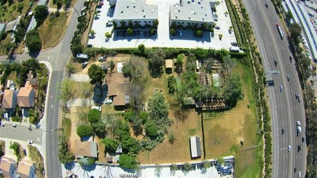

This Property Is For Sale
NEARBY LISTINGS FOR SALE OR LEASE
Property Detail
2355 Montiel Rd
San Diego-Chula Vista-Carlsbad, CA
Rancho Los Vallecitos De San M
228-370-20
BLK 7 LOT 16 SELY 100 FT OF NWLY 225 FT OF NELY 180 FT OF TR 000806
Sfr
San Diego
X
California
06073C0813G
16
2024
0.41 AC
2025
San Marcos
020309
San Diego
1,421 SF
DEMOGRAPHICS near 2355 Montiel Rd
1 mile
3 mile
5 mile
2024 Total Population
7,596
122,137
227,677
2029 Population
7,571
120,881
225,199
Pop Growth 2024-2029
(0.33%)
(1.03%)
(1.09%)
Average Age
38
38
38
2024 Total Households
2,520
39,534
72,525
HH Growth 2024-2029
(0.52%)
(1.19%)
(1.27%)
Median Household Inc
$81,460
$74,021
$82,445
Avg Household Size
2.90
2.90
3.00
2024 Avg HH Vehicles
2.00
2.00
2.00
Median Home Value
$603,024
$631,729
$689,510
Median Year Built
1978
1979
1982
Nearby Places
Map Layers
Map Styles
 Street
 Aerial
Transit
 Traffic
 Biking
Places
Listings with unknown addresses are not visible on the map
- Restaurants
- Banks
- Shops
- Fitness
- Groceries
PUBLIC TRANSPORTATION
TRANSIT/SUBWAY
Nordahl Road (Sprinter - San Diego North County Transit District (Coaster/Sprinter/Breeze))
Drive
Walk
Distance
Nordahl Road (Sprinter - San Diego North County Transit District (Coaster/Sprinter/Breeze))
3 min
17 min
0.9 mi
AIRPORT
San Diego International
Drive
Walk
Distance
San Diego International
43 min
32.4 mi
Freight Ports
Port of San Diego
Drive
Walk
Distance
Port of San Diego
46 min
34.6 mi
Nearby Properties
Address
Land Use
TOTAL SIZE
Lot Size
Zoning
Address
Land Use
TOTAL SIZE
Lot Size
Zoning
14.98 AC
R-1-10
Address
Land Use
TOTAL SIZE
Lot Size
Zoning
9.77 AC
PD-R-18
Address
Land Use
TOTAL SIZE
Lot Size
Zoning
10.82 AC
SPA
Address
Land Use
TOTAL SIZE
Lot Size
Zoning
Address
Land Use
TOTAL SIZE
Lot Size
Zoning
71,656 SF
S-P
Address
Land Use
TOTAL SIZE
Lot Size
Zoning
Address
Land Use
TOTAL SIZE
Lot Size
Zoning
9.88 AC
R-3-10
Address
Land Use
TOTAL SIZE
Lot Size
Zoning
SPECIFIC P
Address
Land Use
TOTAL SIZE
Lot Size
Zoning
75,138 SF
C
Address
Land Use
TOTAL SIZE
Lot Size
Zoning
80,064 SF
1.53 AC
S-P
Address
Land Use
TOTAL SIZE
Lot Size
Zoning
7.90 AC
PD-C
Address
Land Use
TOTAL SIZE
Lot Size
Zoning
7.60 AC
R-3-18
Address
Land Use
TOTAL SIZE
Lot Size
Zoning
Address
Land Use
TOTAL SIZE
Lot Size
Zoning
5.94 AC
PD-R-24
Address
Land Use
TOTAL SIZE
Lot Size
Zoning
99,461 SF
4.89 AC
SPA
Address
Land Use
TOTAL SIZE
Lot Size
Zoning
10.80 AC
SPA
Address
Land Use
TOTAL SIZE
Lot Size
Zoning
1.94 AC
C
Address
Land Use
TOTAL SIZE
Lot Size
Zoning
8.30 AC
R-2-12
Address
Land Use
TOTAL SIZE
Lot Size
Zoning
Address
Land Use
TOTAL SIZE
Lot Size
Zoning
97,874 SF
8.47 AC
R-2-12
Address
Land Use
TOTAL SIZE
Lot Size
Zoning
1.49 AC
SPA
Address
Land Use
TOTAL SIZE
Lot Size
Zoning
2.98 AC
S-P
Address
Land Use
TOTAL SIZE
Lot Size
Zoning
13.99 AC
PD-C
Address
Land Use
TOTAL SIZE
Lot Size
Zoning
7.06 AC
SR
Address
Land Use
TOTAL SIZE
Lot Size
Zoning
6.24 AC
R-3-18
Address
Land Use
TOTAL SIZE
Lot Size
Zoning
95,713 SF
0.51 AC
C
Address
Land Use
TOTAL SIZE
Lot Size
Zoning
97,090 SF
5.38 AC
R-3-18
Address
Land Use
TOTAL SIZE
Lot Size
Zoning
3.06 AC
S-P
Address
Land Use
TOTAL SIZE
Lot Size
Zoning
16.12 AC
SPA
Address
Land Use
TOTAL SIZE
Lot Size
Zoning
10.83 AC
SPA
The World's #1 Commercial Real Estate Marketplace
Connect with us
© 2026 CoStar Group
The information above has been obtained from sources believed reliable. While we do not doubt its accuracy we have not verified it and make no guarantee, warranty or representation about it. It is your responsibility to independently confirm its accuracy and completeness. Any projections, opinions, assumptions, or estimates used are for example only and do not represent the current or future performance of the property. The value of this transaction to you depends on tax and other factors which should be evaluated by your tax, financial, and legal advisors. You and your advisors should conduct a careful, independent investigation of the property to determine to your satisfaction the suitability of the property for your needs.