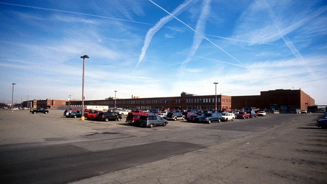
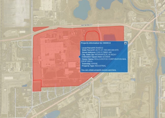
Property Record
2355 S Tibbs Ave, Indianapolis, IN 46241
NEARBY LISTINGS FOR SALE OR LEASE
Property Detail
2355 S Tibbs Ave
Indianapolis-Carmel-Anderson, IN
PT NW1/4 OF SW1/4 & SW1/4 OF NW1/4 S21 T15 R3 BEG305.08FT N & 50.01FT W OF SW COR NW1/4 TO BEG PNT E351.99FT S 325FT W 6FT S 165FT W 350.96FT N IRR490.55FT TO BEG 4.086 AC
49-11-21-106-005.000-970
Marion
Heavyindustrial
Indiana
2023
193.41 AC
2024
Stout Field
342400
Indianapolis
595,354 SF
DEMOGRAPHICS near 2355 S Tibbs Ave
1 Mile
3 Mile
5 Mile
2024 Total Population
2,011
47,384
198,801
2029 Population
2,020
47,272
199,114
Pop Growth 2024-2029
+ 0.45%
(0.24%)
+ 0.16%
Average Age
37
36
35
2024 Total Households
733
17,525
81,751
HH Growth 2024-2029
+ 0.41%
(0.31%)
+ 0.28%
Median Household Inc
$51,790
$47,800
$54,900
Avg Household Size
2.70
2.60
2.30
2024 Avg HH Vehicles
2.00
2.00
2.00
Median Home Value
$79,364
$85,377
$148,466
Median Year Built
1954
1953
1963
Nearby Places
Map Layers
Map Styles
 Street
 Aerial
- Restaurants
- Banks
- Shops
- Fitness
- Groceries
PUBLIC TRANSPORTATION
COMMUTER RAIL
Indianapolis (Cardinal - Amtrak)
DRIVE
WALK
Distance
Indianapolis (Cardinal - Amtrak)
8 min
4.1 mi
AIRPORT
Indianapolis International
DRIVE
WALK
Distance
Indianapolis International
21 min
10.1 mi
Freight Ports
Port of Toledo
DRIVE
WALK
Distance
Port of Toledo
278 min
230.6 mi
Nearby Properties
Address
Land Use
TOTAL SIZE
Lot Size
Zoning
Address
Land Use
TOTAL SIZE
Lot Size
Zoning
111,238 SF
0.06 AC
ZO01
Address
Land Use
TOTAL SIZE
Lot Size
Zoning
67,783 SF
44.97 AC
ZO01
Address
Land Use
TOTAL SIZE
Lot Size
Zoning
405,888 SF
19.56 AC
ZO01
Address
Land Use
TOTAL SIZE
Lot Size
Zoning
51,801 SF
0.06 AC
ZO01
Address
Land Use
TOTAL SIZE
Lot Size
Zoning
366,600 SF
29.05 AC
ZO01
Address
Land Use
TOTAL SIZE
Lot Size
Zoning
132 SF
3.26 AC
ZO01
Address
Land Use
TOTAL SIZE
Lot Size
Zoning
49,008 SF
4.80 AC
ZO01
Address
Land Use
TOTAL SIZE
Lot Size
Zoning
4,663 SF
7.98 AC
ZO01
Address
Land Use
TOTAL SIZE
Lot Size
Zoning
600,000 SF
41.64 AC
ZO01
Address
Land Use
TOTAL SIZE
Lot Size
Zoning
61,832 SF
0.06 AC
ZO01
Address
Land Use
TOTAL SIZE
Lot Size
Zoning
1.88 AC
ZO01
Address
Land Use
TOTAL SIZE
Lot Size
Zoning
101,718 SF
49.77 AC
ZO01
Address
Land Use
TOTAL SIZE
Lot Size
Zoning
378,039 SF
0.06 AC
ZO01
Address
Land Use
TOTAL SIZE
Lot Size
Zoning
20,143 SF
17.10 AC
ZO01
Address
Land Use
TOTAL SIZE
Lot Size
Zoning
537,085 SF
111.99 AC
ZO01
Address
Land Use
TOTAL SIZE
Lot Size
Zoning
438,419 SF
17.26 AC
ZO01
Address
Land Use
TOTAL SIZE
Lot Size
Zoning
150,376 SF
7.30 AC
ZO01
Address
Land Use
TOTAL SIZE
Lot Size
Zoning
113,213 SF
0.06 AC
ZO01
Address
Land Use
TOTAL SIZE
Lot Size
Zoning
75,012 SF
0.06 AC
ZO01
Address
Land Use
TOTAL SIZE
Lot Size
Zoning
290,347 SF
30.40 AC
ZO01
Address
Land Use
TOTAL SIZE
Lot Size
Zoning
18,209 SF
38.23 AC
ZO01
Address
Land Use
TOTAL SIZE
Lot Size
Zoning
43,122 SF
1.01 AC
ZO01
Address
Land Use
TOTAL SIZE
Lot Size
Zoning
484,008 SF
17.95 AC
ZO01
Address
Land Use
TOTAL SIZE
Lot Size
Zoning
119,063 SF
0.06 AC
ZO01
Address
Land Use
TOTAL SIZE
Lot Size
Zoning
339,000 SF
9.59 AC
ZO01
Address
Land Use
TOTAL SIZE
Lot Size
Zoning
882,000 SF
194.98 AC
ZO01
Address
Land Use
TOTAL SIZE
Lot Size
Zoning
257,337 SF
0.06 AC
ZO01
Address
Land Use
TOTAL SIZE
Lot Size
Zoning
282,183 SF
23.96 AC
ZO01
Address
Land Use
TOTAL SIZE
Lot Size
Zoning
207,214 SF
6.43 AC
ZO01
The World's #1 Commercial Real Estate Marketplace
Connect with us
© 2026 CoStar Group
The information above has been obtained from sources believed reliable. While we do not doubt its accuracy we have not verified it and make no guarantee, warranty or representation about it. It is your responsibility to independently confirm its accuracy and completeness. Any projections, opinions, assumptions, or estimates used are for example only and do not represent the current or future performance of the property. The value of this transaction to you depends on tax and other factors which should be evaluated by your tax, financial, and legal advisors. You and your advisors should conduct a careful, independent investigation of the property to determine to your satisfaction the suitability of the property for your needs.