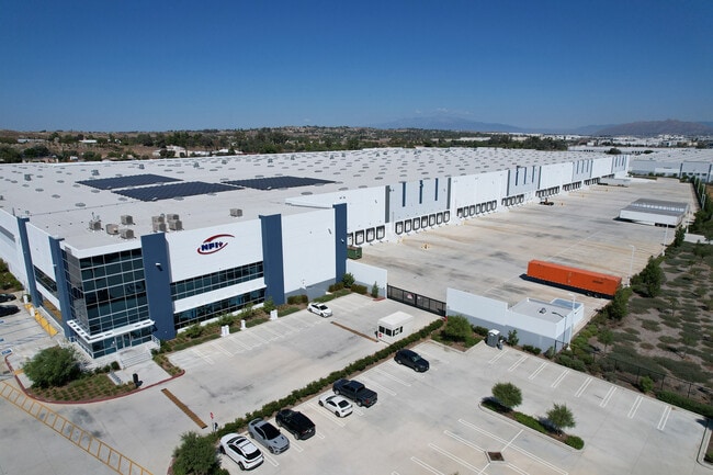
Property Record
20421 Sharon Ann Ln, Perris, CA 92570

Current Lease Availabilities
NEARBY LISTINGS FOR SALE OR LEASE
Property Detail
20421 Sharon Ann Ln
Riverside-San Bernardino-Ontario, CA
Chandlers Sub
317-240-019
Riverside
Sfr
California
X
1 AC
06065C1430H
Moreno Valley/Perris
1,632 SF
Inland Empire (California)
DEMOGRAPHICS near 20421 Sharon Ann Ln
1 Mile
3 Mile
5 Mile
2024 Total Population
793
58,924
125,491
2029 Population
840
62,060
132,211
Pop Growth 2024-2029
+ 5.93%
+ 5.32%
+ 5.35%
Average Age
35
33
33
2024 Total Households
190
13,708
29,749
HH Growth 2024-2029
+ 6.32%
+ 5.00%
+ 5.05%
Median Household Inc
$93,749
$70,683
$74,639
Avg Household Size
3.90
4.00
4.00
2024 Avg HH Vehicles
3.00
3.00
3.00
Median Home Value
$488,234
$362,071
$378,745
Median Year Built
1981
1991
1992
Nearby Places
Map Layers
Map Styles
 Street
 Aerial
- Restaurants
- Banks
- Shops
- Fitness
- Groceries
PUBLIC TRANSPORTATION
COMMUTER RAIL
Perris Downtown (Metrolink 91-Perris Valley Line - Metrolink Trains)
DRIVE
WALK
Distance
Perris Downtown (Metrolink 91-Perris Valley Line - Metrolink Trains)
5 min
3.3 mi
South Perris (Metrolink 91-Perris Valley Line - Metrolink Trains)
DRIVE
WALK
Distance
South Perris (Metrolink 91-Perris Valley Line - Metrolink Trains)
9 min
5.4 mi
AIRPORT
Ontario International
DRIVE
WALK
Distance
Ontario International
40 min
31.8 mi
Freight Ports
Port of Long Beach
DRIVE
WALK
Distance
Port of Long Beach
90 min
66.6 mi
Nearby Properties
Address
Land Use
TOTAL SIZE
Lot Size
Zoning
Address
Land Use
TOTAL SIZE
Lot Size
Zoning
1,530,974 SF
71.21 AC
Address
Land Use
TOTAL SIZE
Lot Size
Zoning
1,189,664 SF
55.26 AC
Address
Land Use
TOTAL SIZE
Lot Size
Zoning
1,224,874 SF
59.05 AC
Address
Land Use
TOTAL SIZE
Lot Size
Zoning
1,009,869 SF
46.76 AC
Address
Land Use
TOTAL SIZE
Lot Size
Zoning
783,407 SF
36.72 AC
Address
Land Use
TOTAL SIZE
Lot Size
Zoning
656,695 SF
30.75 AC
RA5
Address
Land Use
TOTAL SIZE
Lot Size
Zoning
1,138,800 SF
43.93 AC
Address
Land Use
TOTAL SIZE
Lot Size
Zoning
1,309,754 SF
57.79 AC
IL
Address
Land Use
TOTAL SIZE
Lot Size
Zoning
579,708 SF
17.70 AC
LI
Address
Land Use
TOTAL SIZE
Lot Size
Zoning
343 SF
83.52 AC
LI
Address
Land Use
TOTAL SIZE
Lot Size
Zoning
678,087 SF
30.24 AC
Address
Land Use
TOTAL SIZE
Lot Size
Zoning
83.15 AC
Address
Land Use
TOTAL SIZE
Lot Size
Zoning
436,350 SF
19.47 AC
Address
Land Use
TOTAL SIZE
Lot Size
Zoning
1,364,580 SF
80.02 AC
Address
Land Use
TOTAL SIZE
Lot Size
Zoning
692,465 SF
34.46 AC
Address
Land Use
TOTAL SIZE
Lot Size
Zoning
325,560 SF
16.65 AC
Address
Land Use
TOTAL SIZE
Lot Size
Zoning
1,297,200 SF
57.36 AC
Address
Land Use
TOTAL SIZE
Lot Size
Zoning
1,172,289 SF
41.82 AC
Address
Land Use
TOTAL SIZE
Lot Size
Zoning
348,375 SF
21.80 AC
Address
Land Use
TOTAL SIZE
Lot Size
Zoning
1,582,985 SF
83.28 AC
LI
Address
Land Use
TOTAL SIZE
Lot Size
Zoning
285,482 SF
9.65 AC
Address
Land Use
TOTAL SIZE
Lot Size
Zoning
800,218 SF
37.43 AC
Address
Land Use
TOTAL SIZE
Lot Size
Zoning
1,387,899 SF
49.40 AC
Address
Land Use
TOTAL SIZE
Lot Size
Zoning
355,031 SF
16.29 AC
LI
Address
Land Use
TOTAL SIZE
Lot Size
Zoning
406,650 SF
21.49 AC
Address
Land Use
TOTAL SIZE
Lot Size
Zoning
864,000 SF
43.64 AC
RA10
Address
Land Use
TOTAL SIZE
Lot Size
Zoning
426,546 SF
14.78 AC
LI
Address
Land Use
TOTAL SIZE
Lot Size
Zoning
753,895 SF
36.38 AC
The World's #1 Commercial Real Estate Marketplace
Connect with us
© 2026 CoStar Group
The information above has been obtained from sources believed reliable. While we do not doubt its accuracy we have not verified it and make no guarantee, warranty or representation about it. It is your responsibility to independently confirm its accuracy and completeness. Any projections, opinions, assumptions, or estimates used are for example only and do not represent the current or future performance of the property. The value of this transaction to you depends on tax and other factors which should be evaluated by your tax, financial, and legal advisors. You and your advisors should conduct a careful, independent investigation of the property to determine to your satisfaction the suitability of the property for your needs.