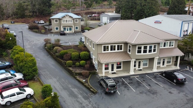
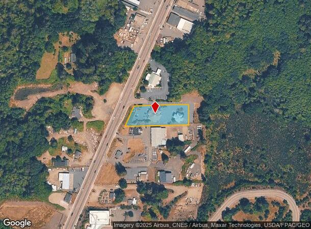
Property Record
23552 Ne State Route 3, Belfair, WA 98528
NEARBY LISTINGS FOR SALE OR LEASE
Property Detail
23552 Ne State Route 3
Shelton, WA
Sp 1852
12329-43-90173
PCL 1 OF BLA #22-08 AF #2185584 PCL 3 OF SP #1852 EX E 92 PTN OF SW SE
Financialbuilding
Mason
X
Washington
53045C0329E
3
2024
0.77 AC
2025
Washington State Area
960401
Other Market Areas
5,144 SF
DEMOGRAPHICS near 23552 Ne State Route 3
1 Mile
3 Mile
5 Mile
2024 Total Population
1,058
5,550
12,277
2029 Population
1,158
6,102
13,350
Pop Growth 2024-2029
+ 9.45%
+ 9.95%
+ 8.74%
Average Age
39
38
42
2024 Total Households
368
1,922
4,533
HH Growth 2024-2029
+ 8.70%
+ 9.52%
+ 8.36%
Median Household Inc
$61,800
$71,867
$87,294
Avg Household Size
2.60
2.60
2.50
2024 Avg HH Vehicles
2.00
3.00
3.00
Median Home Value
$268,859
$312,104
$382,194
Median Year Built
1993
1992
1992
Nearby Places
Map Layers
Map Styles
 Street
 Aerial
- Restaurants
- Banks
- Shops
- Fitness
- Groceries
SALE & LEASE HISTORY
LISTING DATE
SALE/LEASE

Jul 30, 2025
For Lease
Jan 19, 2018
For Lease
Jan 11, 2017
For Lease
Feb 07, 2023
For Sale
Nearby Properties
Address
Land Use
TOTAL SIZE
Lot Size
Zoning
Address
Land Use
TOTAL SIZE
Lot Size
Zoning
51,485 SF
640 AC
LTCF
Address
Land Use
TOTAL SIZE
Lot Size
Zoning
50,011 SF
4.69 AC
GC
Address
Land Use
TOTAL SIZE
Lot Size
Zoning
48,772 SF
28.09 AC
R4
Address
Land Use
TOTAL SIZE
Lot Size
Zoning
112,937 SF
5.29 AC
RI
Address
Land Use
TOTAL SIZE
Lot Size
Zoning
54,760 SF
3.80 AC
FR
Address
Land Use
TOTAL SIZE
Lot Size
Zoning
46,577 SF
8.68 AC
FR
Address
Land Use
TOTAL SIZE
Lot Size
Zoning
20.05 AC
RR10
Address
Land Use
TOTAL SIZE
Lot Size
Zoning
47,660 SF
6.61 AC
PSIC-B
Address
Land Use
TOTAL SIZE
Lot Size
Zoning
4,233 SF
640 AC
LTCF
Address
Land Use
TOTAL SIZE
Lot Size
Zoning
112,230 SF
12.12 AC
GCBI
Address
Land Use
TOTAL SIZE
Lot Size
Zoning
17,134 SF
2.12 AC
GC
Address
Land Use
TOTAL SIZE
Lot Size
Zoning
19,292 SF
1.10 AC
GC
Address
Land Use
TOTAL SIZE
Lot Size
Zoning
10,834 SF
2.68 AC
MU
Address
Land Use
TOTAL SIZE
Lot Size
Zoning
7,451 SF
50.62 AC
RR5
Address
Land Use
TOTAL SIZE
Lot Size
Zoning
17,296 SF
4.03 AC
R4
Address
Land Use
TOTAL SIZE
Lot Size
Zoning
5,428 SF
0.72 AC
Address
Land Use
TOTAL SIZE
Lot Size
Zoning
12,800 SF
6.36 AC
R4
Address
Land Use
TOTAL SIZE
Lot Size
Zoning
20,262 SF
2.60 AC
MU
Address
Land Use
TOTAL SIZE
Lot Size
Zoning
16,544 SF
2.47 AC
MU
Address
Land Use
TOTAL SIZE
Lot Size
Zoning
8,824 SF
2.68 AC
MU
Address
Land Use
TOTAL SIZE
Lot Size
Zoning
14,538 SF
3.51 AC
GC
Address
Land Use
TOTAL SIZE
Lot Size
Zoning
6,908 SF
1.63 AC
GC
Address
Land Use
TOTAL SIZE
Lot Size
Zoning
6,000 SF
9.78 AC
R4
Address
Land Use
TOTAL SIZE
Lot Size
Zoning
4,837 SF
2.80 AC
MU
Address
Land Use
TOTAL SIZE
Lot Size
Zoning
9,620 SF
1 AC
MU
Address
Land Use
TOTAL SIZE
Lot Size
Zoning
6,196 SF
4.16 AC
RR5
Address
Land Use
TOTAL SIZE
Lot Size
Zoning
3,616 SF
1.47 AC
MU
Address
Land Use
TOTAL SIZE
Lot Size
Zoning
3,840 SF
0.69 AC
FR
Address
Land Use
TOTAL SIZE
Lot Size
Zoning
8,474 SF
0.37 AC
FR
The World's #1 Commercial Real Estate Marketplace
Connect with us
© 2026 CoStar Group
The information above has been obtained from sources believed reliable. While we do not doubt its accuracy we have not verified it and make no guarantee, warranty or representation about it. It is your responsibility to independently confirm its accuracy and completeness. Any projections, opinions, assumptions, or estimates used are for example only and do not represent the current or future performance of the property. The value of this transaction to you depends on tax and other factors which should be evaluated by your tax, financial, and legal advisors. You and your advisors should conduct a careful, independent investigation of the property to determine to your satisfaction the suitability of the property for your needs.