Property Record
23562 Ford Rd, Porter, TX 77365
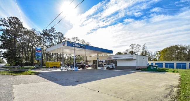

Property Detail
23562 Ford Rd
Houston-Pasadena-The Woodlands, TX
S210000 - ADAMS OAKS 01, LOT 1
2100-00-00100
Montgomery
Commercialnec
Texas
B and X Area of moderate flood hazard, usually the area between the limits of the 100-year and 500-year floods.
1
2024
0.86 AC
2025
Montgomery County
692401
Houston
9,400 SF
NEARBY LISTINGS FOR SALE OR LEASE
DEMOGRAPHICS near 23562 Ford Rd
1 mile
3 mile
5 mile
2024 Total Population
5,625
62,400
137,089
2029 Population
6,616
69,824
154,467
Pop Growth 2024-2029
+ 17.62%
+ 11.90%
+ 12.68%
Average Age
37
37
38
2024 Total Households
1,942
21,715
49,176
HH Growth 2024-2029
+ 18.23%
+ 12.38%
+ 13.14%
Median Household Inc
$69,833
$96,635
$95,600
Avg Household Size
2.80
2.80
2.70
2024 Avg HH Vehicles
2.00
2.00
2.00
Median Home Value
$228,391
$294,573
$313,385
Median Year Built
1997
1997
1999
Nearby Places
Map Layers
Map Styles
 Street
 Aerial
Transit
 Traffic
 Biking
Places
Listings with unknown addresses are not visible on the map
- Restaurants
- Banks
- Shops
- Fitness
- Groceries
PUBLIC TRANSPORTATION
AIRPORT
George Bush Intcntl/Houston
Drive
Walk
Distance
George Bush Intcntl/Houston
25 min
17.8 mi
William P Hobby
Drive
Walk
Distance
William P Hobby
57 min
39.4 mi
Freight Ports
Port of Houston
Drive
Walk
Distance
Port of Houston
46 min
33.1 mi
SALE & LEASE HISTORY
LISTING DATE
SALE/LEASE

Feb 13, 2019
For Sale
Nearby Properties
Address
Land Use
TOTAL SIZE
Lot Size
Zoning
Address
Land Use
TOTAL SIZE
Lot Size
Zoning
298,715 SF
16.28 AC
Address
Land Use
TOTAL SIZE
Lot Size
Zoning
343,814 SF
12.83 AC
Address
Land Use
TOTAL SIZE
Lot Size
Zoning
444,537 SF
55.21 AC
5
Address
Land Use
TOTAL SIZE
Lot Size
Zoning
282,880 SF
12.34 AC
Address
Land Use
TOTAL SIZE
Lot Size
Zoning
154,584 SF
46.76 AC
Address
Land Use
TOTAL SIZE
Lot Size
Zoning
161,302 SF
60.09 AC
5
Address
Land Use
TOTAL SIZE
Lot Size
Zoning
256,120 SF
9.81 AC
Address
Land Use
TOTAL SIZE
Lot Size
Zoning
128,976 SF
16.99 AC
Address
Land Use
TOTAL SIZE
Lot Size
Zoning
215,554 SF
20.89 AC
5
Address
Land Use
TOTAL SIZE
Lot Size
Zoning
76,292 SF
32.01 AC
5
Address
Land Use
TOTAL SIZE
Lot Size
Zoning
165,381 SF
16.60 AC
Address
Land Use
TOTAL SIZE
Lot Size
Zoning
62,172 SF
6.02 AC
Address
Land Use
TOTAL SIZE
Lot Size
Zoning
190,424 SF
23 AC
Address
Land Use
TOTAL SIZE
Lot Size
Zoning
224,810 SF
21.64 AC
5
Address
Land Use
TOTAL SIZE
Lot Size
Zoning
38,994 SF
4.82 AC
5
Address
Land Use
TOTAL SIZE
Lot Size
Zoning
126,662 SF
6.08 AC
Address
Land Use
TOTAL SIZE
Lot Size
Zoning
128,079 SF
5.30 AC
Address
Land Use
TOTAL SIZE
Lot Size
Zoning
13,238 SF
35 AC
Address
Land Use
TOTAL SIZE
Lot Size
Zoning
139,838 SF
38.71 AC
Address
Land Use
TOTAL SIZE
Lot Size
Zoning
154,800 SF
3.10 AC
Address
Land Use
TOTAL SIZE
Lot Size
Zoning
82,740 SF
5.25 AC
5
Address
Land Use
TOTAL SIZE
Lot Size
Zoning
131,028 SF
9.46 AC
Address
Land Use
TOTAL SIZE
Lot Size
Zoning
66,242 SF
2.15 AC
Address
Land Use
TOTAL SIZE
Lot Size
Zoning
108,844 SF
12.64 AC
Address
Land Use
TOTAL SIZE
Lot Size
Zoning
45,077 SF
5.17 AC
Address
Land Use
TOTAL SIZE
Lot Size
Zoning
98,481 SF
27.47 AC
Address
Land Use
TOTAL SIZE
Lot Size
Zoning
51,659 SF
8.81 AC
Address
Land Use
TOTAL SIZE
Lot Size
Zoning
52,646 SF
9.86 AC
Address
Land Use
TOTAL SIZE
Lot Size
Zoning
113,545 SF
10.70 AC
Address
Land Use
TOTAL SIZE
Lot Size
Zoning
128,724 SF
29.89 AC
The World's #1 Commercial Real Estate Marketplace
Connect with us
© 2026 CoStar Group
The information above has been obtained from sources believed reliable. While we do not doubt its accuracy we have not verified it and make no guarantee, warranty or representation about it. It is your responsibility to independently confirm its accuracy and completeness. Any projections, opinions, assumptions, or estimates used are for example only and do not represent the current or future performance of the property. The value of this transaction to you depends on tax and other factors which should be evaluated by your tax, financial, and legal advisors. You and your advisors should conduct a careful, independent investigation of the property to determine to your satisfaction the suitability of the property for your needs.