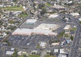
Property Record
2357 Myers St, Oroville, CA 95966

NEARBY LISTINGS FOR SALE OR LEASE
Property Detail
2357 Myers St
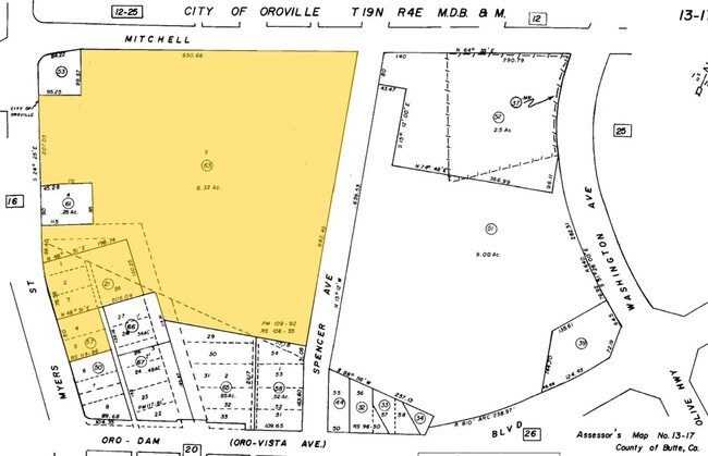
013-170-063-000
Official Map Of Danielson & Browns Subdi
Storebuilding
PCL 5 PM 109-92 PLUS ABAND RD
X
Butte
06007C0795E
California
2024
8.32 AC
2025
California North Rural Area
002800
Other Market Areas
44,461 SF
Chico, CA
DEMOGRAPHICS near 2357 Myers St
1 Mile
3 Mile
5 Mile
2024 Total Population
10,374
32,017
42,475
2029 Population
10,034
30,910
41,003
Pop Growth 2024-2029
(3.28%)
(3.46%)
(3.47%)
Average Age
37
38
39
2024 Total Households
3,860
11,346
15,424
HH Growth 2024-2029
(3.47%)
(3.57%)
(3.57%)
Median Household Inc
$40,710
$51,166
$53,851
Avg Household Size
2.50
2.70
2.60
2024 Avg HH Vehicles
2.00
2.00
2.00
Median Home Value
$220,781
$257,435
$276,051
Median Year Built
1958
1967
1972
Nearby Places
Map Layers
Map Styles
 Street
 Aerial
- Restaurants
- Banks
- Shops
- Fitness
- Groceries
SALE & LEASE HISTORY
LISTING DATE
SALE/LEASE

Sep 25, 2016
For Lease
Jul 06, 2018
For Sale
Jan 05, 2022
For Lease
Nearby Properties
Address
Land Use
TOTAL SIZE
Lot Size
Zoning
Address
Land Use
TOTAL SIZE
Lot Size
Zoning
14.25 AC
C1
Address
Land Use
TOTAL SIZE
Lot Size
Zoning
17.29 AC
Address
Land Use
TOTAL SIZE
Lot Size
Zoning
182,327 SF
21.17 AC
M2
Address
Land Use
TOTAL SIZE
Lot Size
Zoning
36,746 SF
8.39 AC
Address
Land Use
TOTAL SIZE
Lot Size
Zoning
95,604 SF
8.90 AC
C2
Address
Land Use
TOTAL SIZE
Lot Size
Zoning
2,463 SF
6.96 AC
RP
Address
Land Use
TOTAL SIZE
Lot Size
Zoning
58,808 SF
4.54 AC
C1
Address
Land Use
TOTAL SIZE
Lot Size
Zoning
66,651 SF
5.08 AC
MHDR
Address
Land Use
TOTAL SIZE
Lot Size
Zoning
75,693 SF
3.15 AC
R-4
Address
Land Use
TOTAL SIZE
Lot Size
Zoning
70,306 SF
2.74 AC
R-4
Address
Land Use
TOTAL SIZE
Lot Size
Zoning
58,254 SF
3.52 AC
Address
Land Use
TOTAL SIZE
Lot Size
Zoning
9,874 SF
5 AC
RP
Address
Land Use
TOTAL SIZE
Lot Size
Zoning
102,513 SF
12.11 AC
C2
Address
Land Use
TOTAL SIZE
Lot Size
Zoning
53,941 SF
2.47 AC
C2
Address
Land Use
TOTAL SIZE
Lot Size
Zoning
44,186 SF
4.28 AC
Address
Land Use
TOTAL SIZE
Lot Size
Zoning
5,995 SF
4.75 AC
C2
Address
Land Use
TOTAL SIZE
Lot Size
Zoning
43,536 SF
2.89 AC
Address
Land Use
TOTAL SIZE
Lot Size
Zoning
48,151 SF
1.85 AC
C2
Address
Land Use
TOTAL SIZE
Lot Size
Zoning
52,294 SF
2.12 AC
R3
Address
Land Use
TOTAL SIZE
Lot Size
Zoning
84,500 SF
6.48 AC
C1
Address
Land Use
TOTAL SIZE
Lot Size
Zoning
64,616 SF
5.80 AC
Address
Land Use
TOTAL SIZE
Lot Size
Zoning
37,374 SF
2.36 AC
Address
Land Use
TOTAL SIZE
Lot Size
Zoning
65,172 SF
4.45 AC
PD
Address
Land Use
TOTAL SIZE
Lot Size
Zoning
150,712 SF
7.78 AC
RP
Address
Land Use
TOTAL SIZE
Lot Size
Zoning
126,045 SF
8.87 AC
M2
Address
Land Use
TOTAL SIZE
Lot Size
Zoning
51,999 SF
3.69 AC
CLM
Address
Land Use
TOTAL SIZE
Lot Size
Zoning
36.95 AC
MU-1
Address
Land Use
TOTAL SIZE
Lot Size
Zoning
54,209 SF
5.80 AC
R2M
Address
Land Use
TOTAL SIZE
Lot Size
Zoning
40,435 SF
3 AC
R2
The World's #1 Commercial Real Estate Marketplace
Connect with us
© 2025 CoStar Group
The information above has been obtained from sources believed reliable. While we do not doubt its accuracy we have not verified it and make no guarantee, warranty or representation about it. It is your responsibility to independently confirm its accuracy and completeness. Any projections, opinions, assumptions, or estimates used are for example only and do not represent the current or future performance of the property. The value of this transaction to you depends on tax and other factors which should be evaluated by your tax, financial, and legal advisors. You and your advisors should conduct a careful, independent investigation of the property to determine to your satisfaction the suitability of the property for your needs.