Property Record
2357 N 400 E, Ogden, UT 84414
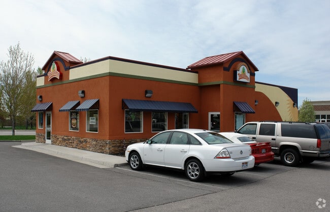

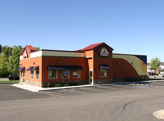

Property Detail
2357 N 400 E
18-106-0003
PART OF THE NORTHEAST QUARTER OF SECTION 32, TOWNSHIP 7 NORTH RANGE 1 WEST, OF THE SALT LAKE BASE & MERIDIAN. ALSO; A PART OF
Restaurantdrivein
WEBER
B and X Area of moderate flood hazard, usually the area between the limits of the 100-year and 500-year floods.
Utah
2025
0.45 AC
2025
Davis/Weber Counties
210305
Salt Lake City
2,220 SF
Ogden, UT
NEARBY LISTINGS FOR SALE OR LEASE
DEMOGRAPHICS near 2357 N 400 E
1 mile
3 mile
5 mile
2025 Total Population
13,411
62,550
102,158
2030 Population
14,152
65,218
106,376
Pop Growth 2025-2030
+ 5.53%
+ 4.27%
+ 4.13%
Average Age
36
36
36
2025 Total Households
4,598
20,291
34,179
HH Growth 2025-2030
+ 5.61%
+ 4.48%
+ 4.33%
Median Household Inc
$94,934
$94,596
$88,057
Avg Household Size
2.90
3.00
2.90
2025 Avg HH Vehicles
2.00
2.00
2.00
Median Home Value
$436,108
$444,307
$431,895
Median Year Built
2002
1995
1991
Nearby Places
Map Layers
Map Styles
 Street
 Aerial
Layers
 Traffic
 Biking
Places
Listings with unknown addresses are not visible on the map
- Restaurants
- Banks
- Shops
- Fitness
- Groceries
PUBLIC TRANSPORTATION
COMMUTER RAIL
Ogden (FrontRunner North - Utah Transit Authority (UTA))
Drive
Walk
Distance
Ogden (FrontRunner North - Utah Transit Authority (UTA))
11 min
5.9 mi
SALE & LEASE HISTORY
LISTING DATE
SALE/LEASE

May 13, 2019
For Sale
May 13, 2019
For Lease
Nearby Properties
Address
Land Use
TOTAL SIZE
Lot Size
Zoning
Address
Land Use
TOTAL SIZE
Lot Size
Zoning
1,154,674 SF
133.48 AC
Address
Land Use
TOTAL SIZE
Lot Size
Zoning
1,001,933 SF
40.73 AC
Address
Land Use
TOTAL SIZE
Lot Size
Zoning
3,544 SF
9.56 AC
Address
Land Use
TOTAL SIZE
Lot Size
Zoning
292,940 SF
17.83 AC
Address
Land Use
TOTAL SIZE
Lot Size
Zoning
264,373 SF
13.52 AC
Address
Land Use
TOTAL SIZE
Lot Size
Zoning
596 SF
8.08 AC
Address
Land Use
TOTAL SIZE
Lot Size
Zoning
14,328 SF
4.28 AC
Address
Land Use
TOTAL SIZE
Lot Size
Zoning
202,499 SF
20.48 AC
Address
Land Use
TOTAL SIZE
Lot Size
Zoning
247,962 SF
19.14 AC
Address
Land Use
TOTAL SIZE
Lot Size
Zoning
10,336 SF
7.05 AC
Address
Land Use
TOTAL SIZE
Lot Size
Zoning
7,632 SF
6.87 AC
Address
Land Use
TOTAL SIZE
Lot Size
Zoning
1,056 SF
34.61 AC
Address
Land Use
TOTAL SIZE
Lot Size
Zoning
228,832 SF
4.61 AC
Address
Land Use
TOTAL SIZE
Lot Size
Zoning
296,653 SF
11.45 AC
Address
Land Use
TOTAL SIZE
Lot Size
Zoning
26,418 SF
9.81 AC
Address
Land Use
TOTAL SIZE
Lot Size
Zoning
178,655 SF
11.61 AC
Address
Land Use
TOTAL SIZE
Lot Size
Zoning
2,239 SF
28.36 AC
Address
Land Use
TOTAL SIZE
Lot Size
Zoning
21,756 SF
2.32 AC
Address
Land Use
TOTAL SIZE
Lot Size
Zoning
122,173 SF
10.95 AC
Address
Land Use
TOTAL SIZE
Lot Size
Zoning
4,686 SF
28.74 AC
Address
Land Use
TOTAL SIZE
Lot Size
Zoning
102,522 SF
13.14 AC
Address
Land Use
TOTAL SIZE
Lot Size
Zoning
130,740 SF
21.64 AC
The World's #1 Commercial Real Estate Marketplace
Connect with us
© 2026 CoStar Group
The information above has been obtained from sources believed reliable. While we do not doubt its accuracy we have not verified it and make no guarantee, warranty or representation about it. It is your responsibility to independently confirm its accuracy and completeness. Any projections, opinions, assumptions, or estimates used are for example only and do not represent the current or future performance of the property. The value of this transaction to you depends on tax and other factors which should be evaluated by your tax, financial, and legal advisors. You and your advisors should conduct a careful, independent investigation of the property to determine to your satisfaction the suitability of the property for your needs.