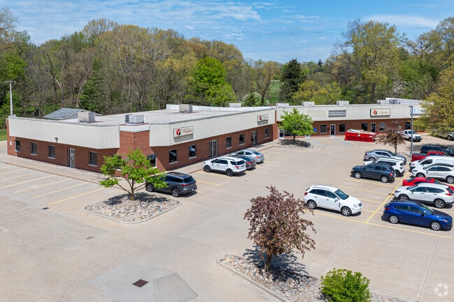
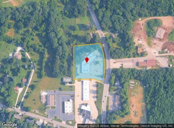
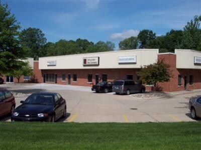
Property Record
2358 N Us Highway 35, La Porte, IN 46350
NEARBY LISTINGS FOR SALE OR LEASE
-
-
-
-
No Photo
-
-
-
View all La Porte listings for sale on LoopNet.com
Property Detail
2358 N Us Highway 35
46-06-22-401-003.000-042
04-06-22-401-003 NW COR W 1/2 SE 1/4 W OF HWY S22 T37 R3 2.66 AC
Officebuilding
La Porte
X
Indiana
18091C0165D
2.66 AC
2023
South Bend/Elkhart
2024
Other Market Areas
042500
Michigan City-La Porte, IN
15,722 SF
DEMOGRAPHICS near 2358 N Us Highway 35
1 Mile
3 Mile
5 Mile
2024 Total Population
1,854
16,896
36,181
2029 Population
1,841
16,764
35,689
Pop Growth 2024-2029
(0.70%)
(0.78%)
(1.36%)
Average Age
43
40
41
2024 Total Households
716
6,598
14,346
HH Growth 2024-2029
(0.70%)
(0.89%)
(1.55%)
Median Household Inc
$106,111
$56,902
$63,790
Avg Household Size
2.50
2.40
2.40
2024 Avg HH Vehicles
2.00
2.00
2.00
Median Home Value
$264,515
$183,211
$181,868
Median Year Built
1986
1957
1964
Nearby Places
Map Layers
Map Styles
 Street
 Aerial
- Restaurants
- Banks
- Shops
- Fitness
- Groceries
PUBLIC TRANSPORTATION
COMMUTER RAIL
Carroll Avenue (Michigan City) Station (South Shore Line - Northern Indiana Commuter Transportation District (South Shore Line))
DRIVE
WALK
Distance
Carroll Avenue (Michigan City) Station (South Shore Line - Northern Indiana Commuter Transportation District (South Shore Line))
15 min
8.8 mi
AIRPORT
South Bend International
DRIVE
WALK
Distance
South Bend International
47 min
31.3 mi
Nearby Properties
Address
Land Use
TOTAL SIZE
Lot Size
Zoning
Address
Land Use
TOTAL SIZE
Lot Size
Zoning
222,443 SF
5.25 AC
Address
Land Use
TOTAL SIZE
Lot Size
Zoning
225,592 SF
3.72 AC
Address
Land Use
TOTAL SIZE
Lot Size
Zoning
482,301 SF
49.97 AC
Address
Land Use
TOTAL SIZE
Lot Size
Zoning
294,600 SF
22.86 AC
Address
Land Use
TOTAL SIZE
Lot Size
Zoning
289,954 SF
15.78 AC
Address
Land Use
TOTAL SIZE
Lot Size
Zoning
237,466 SF
19.13 AC
Address
Land Use
TOTAL SIZE
Lot Size
Zoning
603,796 SF
18.96 AC
Address
Land Use
TOTAL SIZE
Lot Size
Zoning
221,703 SF
16.87 AC
Address
Land Use
TOTAL SIZE
Lot Size
Zoning
150,364 SF
14.26 AC
Address
Land Use
TOTAL SIZE
Lot Size
Zoning
56,034 SF
3.04 AC
Address
Land Use
TOTAL SIZE
Lot Size
Zoning
28,154 SF
2.68 AC
Address
Land Use
TOTAL SIZE
Lot Size
Zoning
36,179 SF
6.15 AC
Address
Land Use
TOTAL SIZE
Lot Size
Zoning
52,830 SF
0.32 AC
Address
Land Use
TOTAL SIZE
Lot Size
Zoning
84,695 SF
37.29 AC
Address
Land Use
TOTAL SIZE
Lot Size
Zoning
19,230 SF
2.32 AC
Address
Land Use
TOTAL SIZE
Lot Size
Zoning
28,986 SF
32.14 AC
Address
Land Use
TOTAL SIZE
Lot Size
Zoning
7,217 SF
0.40 AC
LBCCN
Address
Land Use
TOTAL SIZE
Lot Size
Zoning
31,483 SF
0.78 AC
Address
Land Use
TOTAL SIZE
Lot Size
Zoning
39,780 SF
14 AC
Address
Land Use
TOTAL SIZE
Lot Size
Zoning
164,786 SF
2 AC
Address
Land Use
TOTAL SIZE
Lot Size
Zoning
39,424 SF
1.28 AC
Address
Land Use
TOTAL SIZE
Lot Size
Zoning
6,569 SF
2.38 AC
Address
Land Use
TOTAL SIZE
Lot Size
Zoning
45,375 SF
4.67 AC
Address
Land Use
TOTAL SIZE
Lot Size
Zoning
10,506 SF
2.23 AC
Address
Land Use
TOTAL SIZE
Lot Size
Zoning
50,266 SF
10 AC
Address
Land Use
TOTAL SIZE
Lot Size
Zoning
13,150 SF
4.69 AC
Address
Land Use
TOTAL SIZE
Lot Size
Zoning
37,070 SF
Address
Land Use
TOTAL SIZE
Lot Size
Zoning
30,477 SF
1.68 AC
Address
Land Use
TOTAL SIZE
Lot Size
Zoning
143,610 SF
7.50 AC
Address
Land Use
TOTAL SIZE
Lot Size
Zoning
28,672 SF
0.80 AC
The World's #1 Commercial Real Estate Marketplace
Connect with us
© 2025 CoStar Group
The information above has been obtained from sources believed reliable. While we do not doubt its accuracy we have not verified it and make no guarantee, warranty or representation about it. It is your responsibility to independently confirm its accuracy and completeness. Any projections, opinions, assumptions, or estimates used are for example only and do not represent the current or future performance of the property. The value of this transaction to you depends on tax and other factors which should be evaluated by your tax, financial, and legal advisors. You and your advisors should conduct a careful, independent investigation of the property to determine to your satisfaction the suitability of the property for your needs.