Property Record
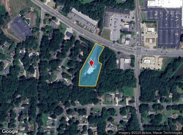
2358 Shallowford Rd, Marietta, GA 30066

This Property Is For Sale
NEARBY LISTINGS FOR SALE OR LEASE
Property Detail
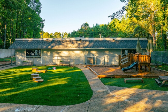
2358 Shallowford Rd
16-0339-0-042-0
Heatherwood
Daycare
Cobb
A
Georgia
13057C0375E
310&339
2025
1.60 AC
2025
Town Center/Marietta
030367
Atlanta
5,117 SF
Atlanta-Sandy Springs-Roswell, GA
DEMOGRAPHICS near 2358 Shallowford Rd
1 Mile
3 Mile
5 Mile
2024 Total Population
8,003
67,306
187,700
2029 Population
8,063
68,499
195,308
Pop Growth 2024-2029
+ 0.75%
+ 1.77%
+ 4.05%
Average Age
40
41
41
2024 Total Households
2,592
23,738
67,990
HH Growth 2024-2029
+ 0.69%
+ 1.93%
+ 4.31%
Median Household Inc
$149,788
$121,603
$113,514
Avg Household Size
3.00
2.80
2.70
2024 Avg HH Vehicles
2.00
2.00
2.00
Median Home Value
$442,030
$370,722
$380,893
Median Year Built
1987
1984
1987
Nearby Places
- Restaurants
- Banks
- Shops
- Fitness
- Groceries
PUBLIC TRANSPORTATION
AIRPORT
Hartsfield - Jackson Atlanta International
DRIVE
WALK
Distance
Hartsfield - Jackson Atlanta International
51 min
33.9 mi
Freight Ports
Georgia Ports - Savannah
DRIVE
WALK
Distance
Georgia Ports - Savannah
314 min
273.2 mi
Nearby Properties
Address
Land Use
TOTAL SIZE
Lot Size
Zoning
Address
Land Use
TOTAL SIZE
Lot Size
Zoning
266,487 SF
21.69 AC
R-4
Address
Land Use
TOTAL SIZE
Lot Size
Zoning
118,464 SF
15.73 AC
CRC
Address
Land Use
TOTAL SIZE
Lot Size
Zoning
139,694 SF
16.35 AC
GC/WS
Address
Land Use
TOTAL SIZE
Lot Size
Zoning
85,166 SF
3.41 AC
DT-CBD
Address
Land Use
TOTAL SIZE
Lot Size
Zoning
186,090 SF
30.08 AC
GC
Address
Land Use
TOTAL SIZE
Lot Size
Zoning
5 AC
PSC/NS
Address
Land Use
TOTAL SIZE
Lot Size
Zoning
126,855 SF
13.71 AC
NS
Address
Land Use
TOTAL SIZE
Lot Size
Zoning
9,840 SF
9.76 AC
CRC
Address
Land Use
TOTAL SIZE
Lot Size
Zoning
115,107 SF
12.90 AC
NRC/NS
Address
Land Use
TOTAL SIZE
Lot Size
Zoning
41,268 SF
13.78 AC
Address
Land Use
TOTAL SIZE
Lot Size
Zoning
140,520 SF
13.44 AC
GC
Address
Land Use
TOTAL SIZE
Lot Size
Zoning
121,844 SF
17.61 AC
CRC/WS
Address
Land Use
TOTAL SIZE
Lot Size
Zoning
116,428 SF
21.33 AC
GC/PSC
Address
Land Use
TOTAL SIZE
Lot Size
Zoning
105,216 SF
10.42 AC
GC
Address
Land Use
TOTAL SIZE
Lot Size
Zoning
109,792 SF
2.56 AC
CRC
Address
Land Use
TOTAL SIZE
Lot Size
Zoning
33,410 SF
4.54 AC
GC/WS
Address
Land Use
TOTAL SIZE
Lot Size
Zoning
2.78 AC
OI
Address
Land Use
TOTAL SIZE
Lot Size
Zoning
33.26 AC
R20
Address
Land Use
TOTAL SIZE
Lot Size
Zoning
2.23 AC
GC/WS
Address
Land Use
TOTAL SIZE
Lot Size
Zoning
41,749 SF
3.61 AC
LRC
Address
Land Use
TOTAL SIZE
Lot Size
Zoning
88,221 SF
10.07 AC
NS/WS
Address
Land Use
TOTAL SIZE
Lot Size
Zoning
90,812 SF
3.10 AC
NRC
Address
Land Use
TOTAL SIZE
Lot Size
Zoning
60,575 SF
9.60 AC
LI
Address
Land Use
TOTAL SIZE
Lot Size
Zoning
41.28 AC
R20
Address
Land Use
TOTAL SIZE
Lot Size
Zoning
65,870 SF
6.24 AC
CRC
Address
Land Use
TOTAL SIZE
Lot Size
Zoning
41,897 SF
4.30 AC
SL
Address
Land Use
TOTAL SIZE
Lot Size
Zoning
63,342 SF
4.94 AC
LI
Address
Land Use
TOTAL SIZE
Lot Size
Zoning
41,752 SF
1.13 AC
PSC
Address
Land Use
TOTAL SIZE
Lot Size
Zoning
81,271 SF
5.06 AC
NRC/WS
Address
Land Use
TOTAL SIZE
Lot Size
Zoning
15,159 SF
2.06 AC
GC
The World's #1 Commercial Real Estate Marketplace
Connect with us
© 2025 CoStar Group
The information above has been obtained from sources believed reliable. While we do not doubt its accuracy we have not verified it and make no guarantee, warranty or representation about it. It is your responsibility to independently confirm its accuracy and completeness. Any projections, opinions, assumptions, or estimates used are for example only and do not represent the current or future performance of the property. The value of this transaction to you depends on tax and other factors which should be evaluated by your tax, financial, and legal advisors. You and your advisors should conduct a careful, independent investigation of the property to determine to your satisfaction the suitability of the property for your needs.