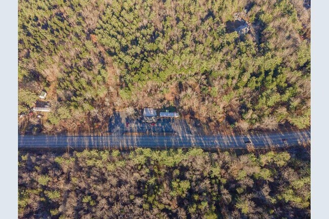
Property Record
236 Fitzwilliam Rd, Troy, NH 03465
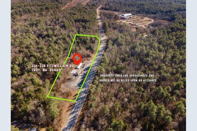
This Property Is For Sale
Property Detail
236 Fitzwilliam Rd
TROY-000005-000010
CHESHIRE
Residentialacreage
New Hampshire
HIGHWA
2 AC
B and X Area of moderate flood hazard, usually the area between the limits of the 100-year and 500-year floods.
Manchester/New Hampshire South Area
2025
Other Market Areas
2025
Keene, NH
970800
NEARBY LISTINGS FOR SALE OR LEASE
-
-
View all Troy listings for sale on LoopNet.com
DEMOGRAPHICS near 236 Fitzwilliam Rd
1 mile
3 mile
5 mile
2025 Total Population
394
2,482
4,397
2030 Population
383
2,427
4,367
Pop Growth 2025-2030
(2.79%)
(2.22%)
(0.68%)
Average Age
43
44
45
2025 Total Households
159
1,014
1,821
HH Growth 2025-2030
(3.14%)
(2.17%)
(0.71%)
Median Household Inc
$88,461
$88,733
$89,683
Avg Household Size
2.40
2.40
2.40
2025 Avg HH Vehicles
2.00
2.00
2.00
Median Home Value
$369,999
$365,356
$369,435
Median Year Built
1970
1971
1972
Nearby Places
Map Layers
Map Styles
 Street
 Aerial
Transit
 Traffic
 Biking
Places
Listings with unknown addresses are not visible on the map
- Restaurants
- Banks
- Shops
- Fitness
- Groceries
Nearby Properties
Address
Land Use
TOTAL SIZE
Lot Size
Zoning
Address
Land Use
TOTAL SIZE
Lot Size
Zoning
17.67 AC
RURAL
Address
Land Use
TOTAL SIZE
Lot Size
Zoning
95,041 SF
18.90 AC
LI L
Address
Land Use
TOTAL SIZE
Lot Size
Zoning
34,657 SF
16 AC
R1
Address
Land Use
TOTAL SIZE
Lot Size
Zoning
7.52 AC
MILL
Address
Land Use
TOTAL SIZE
Lot Size
Zoning
28,172 SF
14.48 AC
VILLAG
Address
Land Use
TOTAL SIZE
Lot Size
Zoning
107.50 AC
RURAL
Address
Land Use
TOTAL SIZE
Lot Size
Zoning
5.64 AC
VILLAG
Address
Land Use
TOTAL SIZE
Lot Size
Zoning
3,123 SF
0.96 AC
GB G
Address
Land Use
TOTAL SIZE
Lot Size
Zoning
27,625 SF
7.30 AC
LI L
Address
Land Use
TOTAL SIZE
Lot Size
Zoning
8,380 SF
5.70 AC
R1
Address
Land Use
TOTAL SIZE
Lot Size
Zoning
30.20 AC
HIGHWA
Address
Land Use
TOTAL SIZE
Lot Size
Zoning
15,568 SF
6.76 AC
HIGHWA
Address
Land Use
TOTAL SIZE
Lot Size
Zoning
9,471 SF
32 AC
RUR
Address
Land Use
TOTAL SIZE
Lot Size
Zoning
9,100 SF
3.25 AC
HIGHWA
Address
Land Use
TOTAL SIZE
Lot Size
Zoning
6.50 AC
HIGHWA
Address
Land Use
TOTAL SIZE
Lot Size
Zoning
0.69 AC
VILLAG
Address
Land Use
TOTAL SIZE
Lot Size
Zoning
1,886 SF
200 AC
RUR
Address
Land Use
TOTAL SIZE
Lot Size
Zoning
3,675 SF
121.20 AC
RUR
Address
Land Use
TOTAL SIZE
Lot Size
Zoning
8,363 SF
1.54 AC
GB G
Address
Land Use
TOTAL SIZE
Lot Size
Zoning
11,148 SF
1.50 AC
VCB
Address
Land Use
TOTAL SIZE
Lot Size
Zoning
3.42 AC
HIGHWA
Address
Land Use
TOTAL SIZE
Lot Size
Zoning
6,335 SF
0.81 AC
R1
Address
Land Use
TOTAL SIZE
Lot Size
Zoning
5,774 SF
0.40 AC
R1
Address
Land Use
TOTAL SIZE
Lot Size
Zoning
3.50 AC
R1
Address
Land Use
TOTAL SIZE
Lot Size
Zoning
1.20 AC
RESIDE
Address
Land Use
TOTAL SIZE
Lot Size
Zoning
4,762 SF
0.62 AC
VILLAG
Address
Land Use
TOTAL SIZE
Lot Size
Zoning
8,984 SF
9.02 AC
HIGHWA
Address
Land Use
TOTAL SIZE
Lot Size
Zoning
2,400 SF
20.60 AC
LI L
Address
Land Use
TOTAL SIZE
Lot Size
Zoning
8,435 SF
0.80 AC
RUR
Address
Land Use
TOTAL SIZE
Lot Size
Zoning
5,084 SF
0.60 AC
R1
The World's #1 Commercial Real Estate Marketplace
Connect with us
© 2026 CoStar Group
The information above has been obtained from sources believed reliable. While we do not doubt its accuracy we have not verified it and make no guarantee, warranty or representation about it. It is your responsibility to independently confirm its accuracy and completeness. Any projections, opinions, assumptions, or estimates used are for example only and do not represent the current or future performance of the property. The value of this transaction to you depends on tax and other factors which should be evaluated by your tax, financial, and legal advisors. You and your advisors should conduct a careful, independent investigation of the property to determine to your satisfaction the suitability of the property for your needs.