Property Record
236 W Main St, Danville, KY 40422
NEARBY LISTINGS FOR SALE OR LEASE
Property Detail
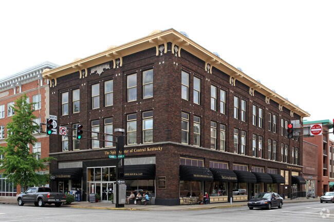
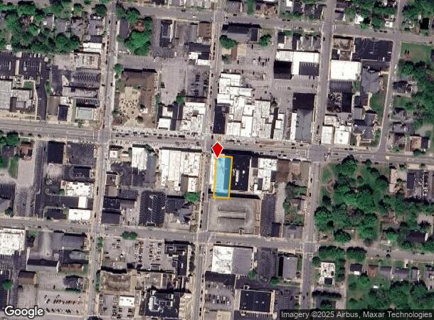
236 W Main St
Officebuilding
HUB BUILDING
X
Boyle
21021C0069C
Kentucky
2025
Kentucky East Area
2025
Other Market Areas
930300
Danville, KY
27,660 SF
D08-017-001
DEMOGRAPHICS near 236 W Main St
1 Mile
3 Mile
5 Mile
2024 Total Population
7,401
19,348
26,170
2029 Population
7,765
20,255
27,405
Pop Growth 2024-2029
+ 4.92%
+ 4.69%
+ 4.72%
Average Age
37
41
41
2024 Total Households
2,806
7,469
10,016
HH Growth 2024-2029
+ 5.52%
+ 5.18%
+ 5.21%
Median Household Inc
$41,922
$50,412
$53,897
Avg Household Size
2.20
2.20
2.30
2024 Avg HH Vehicles
2.00
2.00
2.00
Median Home Value
$177,935
$186,585
$183,863
Median Year Built
1968
1976
1977
Nearby Places
Map Layers
Map Styles
 Street
 Aerial
- Restaurants
- Banks
- Shops
- Fitness
- Groceries
PUBLIC TRANSPORTATION
AIRPORT
Blue Grass
DRIVE
WALK
Distance
Blue Grass
51 min
41.8 mi
Freight Ports
Port of Toledo
DRIVE
WALK
Distance
Port of Toledo
381 min
321.5 mi
SALE & LEASE HISTORY
LISTING DATE
SALE/LEASE

Sep 24, 2016
For Sale
May 26, 2022
For Lease
May 10, 2017
For Sale
Jun 30, 2025
For Sale
Dec 20, 2016
For Sale
Dec 19, 2016
For Sale
Nearby Properties
Address
Land Use
TOTAL SIZE
Lot Size
Zoning
Address
Land Use
TOTAL SIZE
Lot Size
Zoning
73.69 AC
Address
Land Use
TOTAL SIZE
Lot Size
Zoning
80,400 SF
59.35 AC
Address
Land Use
TOTAL SIZE
Lot Size
Zoning
162,110 SF
28.84 AC
Address
Land Use
TOTAL SIZE
Lot Size
Zoning
Address
Land Use
TOTAL SIZE
Lot Size
Zoning
35,921 SF
8.19 AC
Address
Land Use
TOTAL SIZE
Lot Size
Zoning
104,000 SF
39.59 AC
Address
Land Use
TOTAL SIZE
Lot Size
Zoning
Address
Land Use
TOTAL SIZE
Lot Size
Zoning
178,568 SF
24.17 AC
Address
Land Use
TOTAL SIZE
Lot Size
Zoning
6.32 AC
Address
Land Use
TOTAL SIZE
Lot Size
Zoning
195,285 SF
19.89 AC
COMMERCIAL
Address
Land Use
TOTAL SIZE
Lot Size
Zoning
29,182 SF
0.45 AC
COMMERCIAL
Address
Land Use
TOTAL SIZE
Lot Size
Zoning
705,815 SF
316.13 AC
Address
Land Use
TOTAL SIZE
Lot Size
Zoning
309,295 SF
22.36 AC
Address
Land Use
TOTAL SIZE
Lot Size
Zoning
5.40 AC
Address
Land Use
TOTAL SIZE
Lot Size
Zoning
307,746 SF
25.65 AC
Address
Land Use
TOTAL SIZE
Lot Size
Zoning
Address
Land Use
TOTAL SIZE
Lot Size
Zoning
493,456 SF
21.68 AC
Address
Land Use
TOTAL SIZE
Lot Size
Zoning
152,415 SF
24.09 AC
Address
Land Use
TOTAL SIZE
Lot Size
Zoning
15,460 SF
42.81 AC
Address
Land Use
TOTAL SIZE
Lot Size
Zoning
57,140 SF
7.03 AC
COMMERCIAL
Address
Land Use
TOTAL SIZE
Lot Size
Zoning
8,320 SF
Address
Land Use
TOTAL SIZE
Lot Size
Zoning
Address
Land Use
TOTAL SIZE
Lot Size
Zoning
3,139 SF
4.43 AC
Address
Land Use
TOTAL SIZE
Lot Size
Zoning
1,818 SF
0.41 AC
COMMERCIAL
Address
Land Use
TOTAL SIZE
Lot Size
Zoning
9,000 SF
11 AC
COMMERCIAL
Address
Land Use
TOTAL SIZE
Lot Size
Zoning
9.50 AC
Address
Land Use
TOTAL SIZE
Lot Size
Zoning
191,000 SF
37.22 AC
Address
Land Use
TOTAL SIZE
Lot Size
Zoning
42,847 SF
2.91 AC
Address
Land Use
TOTAL SIZE
Lot Size
Zoning
218,700 SF
11.05 AC
Address
Land Use
TOTAL SIZE
Lot Size
Zoning
3.03 AC
The World's #1 Commercial Real Estate Marketplace
Connect with us
© 2026 CoStar Group
The information above has been obtained from sources believed reliable. While we do not doubt its accuracy we have not verified it and make no guarantee, warranty or representation about it. It is your responsibility to independently confirm its accuracy and completeness. Any projections, opinions, assumptions, or estimates used are for example only and do not represent the current or future performance of the property. The value of this transaction to you depends on tax and other factors which should be evaluated by your tax, financial, and legal advisors. You and your advisors should conduct a careful, independent investigation of the property to determine to your satisfaction the suitability of the property for your needs.